Mojave Trails National Monument
| Mojave Trails National Monument | |
|---|---|
|
IUCN category V (protected landscape/seascape) | |
|
Cadiz Dunes, Mojave Trails NM | |
  | |
| Location | San Bernardino County, California, U.S. |
| Coordinates | 34°36′N 116°00′W / 34.6°N 116°W / 34.6; -116Coordinates: 34°36′N 116°00′W / 34.6°N 116°W / 34.6; -116 |
| Area | 1,600,000 acres (650,000 ha) |
| Authorized | February 12, 2016 (2016-Feb-12) |
| Governing body | Bureau of Land Management |
| Website | Mojave Trails National Monument |

Mojave Trails National Monument is a U.S. National Monument located in the state of California between Interstates 15 and 40.[1] It partially surrounds the Mojave National Preserve. The focal point of the new preserve is the remote and nearly pristine Cadiz Dunes that formed from the sand of dry lake beds.[2] It was designated by President Obama on February 12, 2016 along with Castle Mountains National Monument and Sand to Snow National Monument.[3] It is under the control of the Bureau of Land Management.
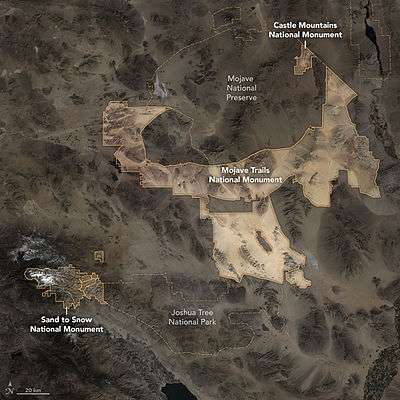
Mojave Trails and other new National Monuments, Mojave desert, 2016
References
- ↑ Sahagun, Louis (February 11, 2016). "Obama creates 3 new national monuments to protect 1.8 million acres of California desert". Los Angeles Times. Retrieved 2016-02-12.
- ↑ A Monumental Addition in California
- ↑ Eilperin, Juliet. "The Washington Post" (February 12, 2016). Retrieved February 12, 2016.
External links
- Bureau of Land Management: Official Mojave Trails National Monument website
- U.S. Dept. of Interior.gov: Map of Mojave Trails National Monument — with wilderness areas.
-
 Media related to Mojave Trails National Monument at Wikimedia Commons
| |
This article is issued from Wikipedia - version of the 11/19/2016. The text is available under the Creative Commons Attribution/Share Alike but additional terms may apply for the media files.