Camino al Tagliamento
| Camino al Tagliamento | |
|---|---|
| Comune | |
| Comune di Camino al Tagliamento | |
 Camino al Tagliamento Location of Camino al Tagliamento in Italy | |
| Coordinates: 45°55′N 12°57′E / 45.917°N 12.950°ECoordinates: 45°55′N 12°57′E / 45.917°N 12.950°E | |
| Country | Italy |
| Region | Friuli-Venezia Giulia |
| Province / Metropolitan city | Province of Udine (UD) |
| Frazioni | Bugnins, Glaunicco, Gorizzo, Pieve di Rosa, San Vidotto, Straccis |
| Area | |
| • Total | 22.6 km2 (8.7 sq mi) |
| Population (Dec. 2004) | |
| • Total | 1,676 |
| • Density | 74/km2 (190/sq mi) |
| Demonym(s) | Caminesi |
| Time zone | CET (UTC+1) |
| • Summer (DST) | CEST (UTC+2) |
| Postal code | 33030 |
| Dialing code | 0432 |
| Website | Official website |
Camino al Tagliamento is a comune (municipality) in the Province of Udine in the Italian region Friuli-Venezia Giulia, located about 70 kilometres (43 mi) northwest of Trieste and about 30 kilometres (19 mi) southwest of Udine. As of 31 December 2004, it had a population of 1,676 and an area of 22.6 square kilometres (8.7 sq mi).[1]
The municipality of Camino al Tagliamento contains the frazioni (subdivisions, mainly villages and hamlets) Bugnins, Glaunicco, Gorizzo, Pieve di Rosa, San Vidotto, and Straccis.
Camino al Tagliamento borders the following municipalities: Codroipo, Morsano al Tagliamento, San Vito al Tagliamento, Varmo.
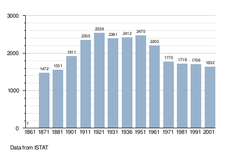
Demographic evolution
References
External links
This article is issued from Wikipedia - version of the 1/31/2015. The text is available under the Creative Commons Attribution/Share Alike but additional terms may apply for the media files.