Paluzza
| Paluzza | ||
|---|---|---|
| Comune | ||
| Comune di Paluzza | ||
|
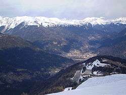
View from Monte Zoncolan | ||
| ||
 Paluzza Location of Paluzza in Italy | ||
| Coordinates: 46°32′N 13°1′E / 46.533°N 13.017°ECoordinates: 46°32′N 13°1′E / 46.533°N 13.017°E | ||
| Country | Italy | |
| Region | Friuli-Venezia Giulia | |
| Province / Metropolitan city | Udine (UD) | |
| Frazioni | Casteons, Cleulis, Naunina, Rivo, Timau | |
| Government | ||
| • Mayor | Elia Vezzi | |
| Area | ||
| • Total | 70.0 km2 (27.0 sq mi) | |
| Population (March 2009[1]) | ||
| • Total | 2,451 | |
| • Density | 35/km2 (91/sq mi) | |
| Time zone | CET (UTC+1) | |
| • Summer (DST) | CEST (UTC+2) | |
| Postal code | 33026 | |
| Dialing code | 0433 | |

Paluzza (Friulian: Paluce) is a comune (municipality) in the Province of Udine in the Italian region Friuli-Venezia Giulia.
Geography
It is located about 120 kilometres (75 mi) northwest of Trieste and about 50 kilometres (31 mi) northwest of Udine, in the historic Carnia region of Friuli, close to the border with Austria at Plöcken Pass (Italian: Passo di Monte Croce Carnico).
Paluzza borders the following municipalities: Arta Terme, Cercivento, Comeglians, Forni Avoltri, Kötschach-Mauthen (Austria), Lesachtal (Austria), Ligosullo, Paularo, Ravascletto, Rigolato, Sutrio, Treppo Carnico. The municipal area comprises the frazioni of Casteons, Cleulis, Englaro, Naunina, Rivo, and Timau (German: Tischelwang), where a particular variant of the Southern Bavarian dialect is spoken.
Sights include the Torre Moscarda, a surviving structure of a castle (Castrum Moscardum) built here by the Patriarch of Aquileia Gregorio di Montelongo; nearby are remains of ancient Roman and World War I fortifications.