Camugnano
| Camugnano | |
|---|---|
| Comune | |
| Comune di Camugnano | |
 Camugnano Location of Camugnano in Italy | |
| Coordinates: 44°10′N 11°6′E / 44.167°N 11.100°ECoordinates: 44°10′N 11°6′E / 44.167°N 11.100°E | |
| Country | Italy |
| Region | Emilia-Romagna |
| Province / Metropolitan city | Province of Bologna (BO) |
| Frazioni | Guzzano, Carpineta, Stagno, Mogne, Verzuno, Vigo, Burzanella, Trasserra, San Damiano, Baigno, Bargi |
| Area | |
| • Total | 96.5 km2 (37.3 sq mi) |
| Elevation | 692 m (2,270 ft) |
| Population (Dec. 2004) | |
| • Total | 2,092 |
| • Density | 22/km2 (56/sq mi) |
| Time zone | CET (UTC+1) |
| • Summer (DST) | CEST (UTC+2) |
| Postal code | 40032 |
| Dialing code | 0534 |
| Website | Official website |
Camugnano is a comune (municipality) in the Province of Bologna in the Italian region Emilia-Romagna, located about 40 kilometres (25 mi) southwest of Bologna. As of 31 December 2004, it had a population of 2,092 and an area of 96.5 square kilometres (37.3 sq mi).[1]
The municipality of Camugnano contains the frazioni (subdivisions, mainly villages and hamlets) Guzzano, Carpineta, Stagno, Mogne, Verzuno, Vigo, Burzanella, Trasserra, San Damiano, Baigno, and Bargi.
Camugnano borders the following municipalities: Cantagallo, Castel di Casio, Castiglione dei Pepoli, Grizzana Morandi, Sambuca Pistoiese, Vernio.
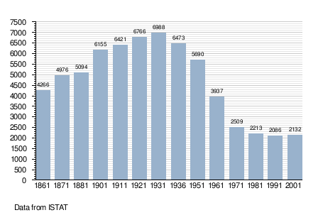
Demographic evolution
References
External links
This article is issued from Wikipedia - version of the 1/31/2015. The text is available under the Creative Commons Attribution/Share Alike but additional terms may apply for the media files.