Bentivoglio, Emilia-Romagna
| Bentivoglio | |
|---|---|
| Comune | |
| Comune di Bentivoglio | |
 Bentivoglio Location of Bentivoglio in Italy | |
| Coordinates: 44°38′N 11°25′E / 44.633°N 11.417°ECoordinates: 44°38′N 11°25′E / 44.633°N 11.417°E | |
| Country | Italy |
| Region | Emilia-Romagna |
| Province / Metropolitan city | Province of Bologna (BO) |
| Area | |
| • Total | 51.1 km2 (19.7 sq mi) |
| Elevation | 19 m (62 ft) |
| Population (Dec. 2004) | |
| • Total | 4,593 |
| • Density | 90/km2 (230/sq mi) |
| Time zone | CET (UTC+1) |
| • Summer (DST) | CEST (UTC+2) |
| Postal code | 40010 |
| Dialing code | 051 |
| Website | Official website |
Bentivoglio is a comune (municipality) in the Province of Bologna in the Italian region of Emilia-Romagna, located about 15 kilometres (9 mi) northeast of Bologna. As of 31 December 2004, it had a population of 4,593 and an area of 51.1 square kilometres (19.7 sq mi).[1]
Bentivoglio borders the following municipalities: Argelato, Castel Maggiore, Granarolo dell'Emilia, Malalbergo, Minerbio, San Giorgio di Piano, San Pietro in Casale.
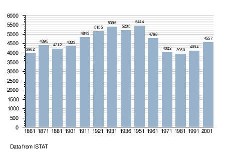
Demographic evolution
Sights
- Museo della civiltà contadina at Villa Smeraldi, Bentivoglio.
References
External links
This article is issued from Wikipedia - version of the 1/31/2015. The text is available under the Creative Commons Attribution/Share Alike but additional terms may apply for the media files.