Cannonville, Utah
| Cannonville, Utah | |
|---|---|
| Town | |
|
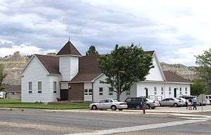
LDS church in Cannonville | |
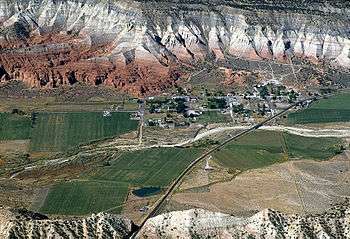
 Location in Garfield County and state of Utah. | |
| Coordinates: 37°34′0″N 112°3′6″W / 37.56667°N 112.05167°WCoordinates: 37°34′0″N 112°3′6″W / 37.56667°N 112.05167°W | |
| Country | United States |
| State | Utah |
| County | Garfield |
| Founded | 1874 |
| Incorporated | 1934 |
| Founded by | James L. Thompson |
| Named for | George Q. Cannon |
| Government | |
| • Mayor | Alma Fletcher |
| • Clerk | Tom Shakespear |
| Area | |
| • Total | 1.2 sq mi (3.2 km2) |
| • Land | 1.2 sq mi (3.2 km2) |
| • Water | 0.0 sq mi (0.0 km2) |
| Elevation | 5,886 ft (1,794 m) |
| Population (2012) | |
| • Total | 163 |
| • Density | 119.9/sq mi (46.3/km2) |
| Time zone | Mountain (MST) (UTC-7) |
| • Summer (DST) | MDT (UTC-6) |
| ZIP code | 84718 |
| Area code(s) | 435 |
| FIPS code | 49-10330[1] |
| GNIS feature ID | 1426344[2] |
Cannonville is a town in Garfield County, Utah, United States, along Utah Scenic Byway 12. In the 2000 census, the population was 148, a small increase over the 1990 figure of 131.
History
A post office called Cannonville was established in 1879, and remained in operation until 1966.[3] The community bears the name of George Q. Cannon, a Mormon official.[4]
Geography
According to the United States Census Bureau, the town has a total area of 1.2 square miles (3.2 km2), none of which is covered with water.
Climate
The climate in this area has a large daily and annual temperature range, with cold, dry winters and hot summers. Rainfall is highly seasonal, with most precipitation falling during the late-summer monsoon season, and total annual precipitation of only 9 inches. According to the Köppen Climate Classification system, Cannonville has a hot and cold arid desert climate, abbreviated "BWk" on climate maps.[5]
Demographics
| Historical population | |||
|---|---|---|---|
| Census | Pop. | %± | |
| 1880 | 137 | — | |
| 1890 | 273 | 99.3% | |
| 1900 | 211 | −22.7% | |
| 1910 | 219 | 3.8% | |
| 1920 | 311 | 42.0% | |
| 1930 | 227 | −27.0% | |
| 1940 | 250 | 10.1% | |
| 1950 | 205 | −18.0% | |
| 1960 | 153 | −25.4% | |
| 1970 | 113 | −26.1% | |
| 1980 | 134 | 18.6% | |
| 1990 | 131 | −2.2% | |
| 2000 | 148 | 13.0% | |
| 2010 | 167 | 12.8% | |
| Est. 2015 | 169 | [6] | 1.2% |
As of the census[1] of 2000, there were 148 people, 50 households, and 41 families residing in the town. The population density was 119.9 people per square mile (46.5/km2). There were 60 housing units at an average density of 48.6 per square mile (18.8/km2). The racial makeup of the town was 95.27% White, 0.68% Pacific Islander, 3.38% from other races, and 0.68% from two or more races. Hispanic or Latino of any race were 4.05% of the population.
There were 50 households out of which 42.0% had children under the age of 18 living with them, 66.0% were married couples living together, 14.0% had a female householder with no husband present, and 18.0% were non-families. 18.0% of all households were made up of individuals and 16.0% had someone living alone who was 65 years of age or older. The average household size was 2.96 and the average family size was 3.34.
In the town the population was spread out with 33.8% under the age of 18, 6.8% from 18 to 24, 19.6% from 25 to 44, 20.3% from 45 to 64, and 19.6% who were 65 years of age or older. The median age was 38 years. For every 100 females there were 117.6 males. For every 100 females age 18 and over, there were 96.0 males.
The median income for a household in the town was $28,750, and the median income for a family was $32,250. Males had a median income of $23,750 versus $12,083 for females. The per capita income for the town was $11,481. None of the families and 3.7% of the population were living below the poverty line, including no under eighteens and 10.9% of those over 64.
References
- 1 2 "American FactFinder". United States Census Bureau. Archived from the original on 2013-09-11. Retrieved 2008-01-31.
- ↑ "US Board on Geographic Names". United States Geological Survey. 2007-10-25. Retrieved 2008-01-31.
- ↑ "Garfield County". Jim Forte Postal History. Retrieved 18 October 2015.
- ↑ Van Atta, Dale (Jan 22, 1977). "You name it - there's a town for it". The Deseret News. p. 15. Retrieved 18 October 2015.
- ↑ Climate Summary for Cannonville, Utah
- ↑ "Annual Estimates of the Resident Population for Incorporated Places: April 1, 2010 to July 1, 2015". Retrieved July 2, 2016.
- ↑ "Census of Population and Housing". Census.gov. Archived from the original on May 11, 2015. Retrieved June 4, 2015.
 |
Bryce Canyon City | Tropic | Escalante | |
| Kanarraville / Bryce Canyon National Park | |
Henrieville | ||
| ||||
| | ||||
| |
|
|
Municipalities and communities of Garfield County, Utah, United States | ||
|---|---|---|
| Cities | 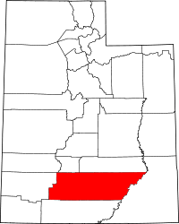 | |
| Towns | ||
| Unincorporated communities | ||
| Ghost towns | ||