Cape Meares

Cape Meares is a small headland on the Pacific coast in Tillamook County, Oregon, United States. The cape forms a high steep bluff on the south end of Tillamook Bay, approximately five miles (8 km) northwest of the city of Tillamook. Much of the cape is part of the Oregon Parks and Recreation Department-administered Cape Meares State Scenic Viewpoint with three miles of hiking trails, which includes the Cape Meares Lighthouse. The cape is named after John Meares, a British explorer.
Geography
Immediately north of the cape is the community of Cape Meares, next to Cape Meares Lake. Cape Meares beach extends north of the community of Cape Meares, along a sand spit, or peninsula, that encloses Tillamook Bay. The peninsula is alternatively known as Bayocean, after a popular upscale resort town that occupied the beach in the early 20th century, until beach erosion began to destroy the town beginning in the 1930s. Today, no significant remnant of the resort town remains on the beach.
Immediately south of Cape Meares is Short Beach.
Cape Meares State Scenic Viewpoint
The scenic viewpoint is the location of the "Octopus Tree", a large, multi-trunked Sitka Spruce[1] with a trunk circumference of about 50 feet. It is accessible via a short hike from the main parking lot.
See also
Gallery
-
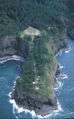
Cape Meares from an airplane
-

Cape Meares seen from Bayocean beach
-

Cape Meares from the north
-

Cape Meares Lighthouse
-
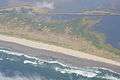
Aerial View of Cape Meares Lake
-
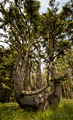
Octopus Tree, Cape Meares, Oregon
References
- ↑ Inc., Let's Go (2005-04-01). Roadtripping USA: The Complete Coast-to-Coast Guide to America. Macmillan. pp. 969–. ISBN 9780312335694. Retrieved 5 February 2013.
External links
- "Cape Meares State Scenic Viewpoint". Oregon Parks and Recreation Department.
- "History of the Cape Meares Lighthouse". Friends of Cape Meares Lighthouse.
Coordinates: 45°29′11″N 123°58′41″W / 45.4863°N 123.978°W