Carbon County, Wyoming
| Carbon County, Wyoming | |
|---|---|
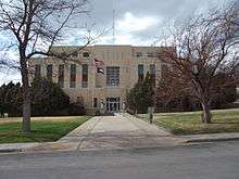 Carbon County Courthouse in Rawlins | |
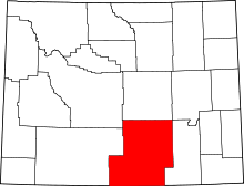 Location in the U.S. state of Wyoming | |
 Wyoming's location in the U.S. | |
| Founded | 1868 |
| Named for | Coal deposits |
| Seat | Rawlins |
| Largest city | Rawlins |
| Area | |
| • Total | 7,964 sq mi (20,627 km2) |
| • Land | 7,898 sq mi (20,456 km2) |
| • Water | 66 sq mi (171 km2), 0.8% |
| Population (est.) | |
| • (2015) | 15,559 |
| • Density | 2.0/sq mi (1/km²) |
| Congressional district | At-large |
| Time zone | Mountain: UTC-7/-6 |
| Website |
www |


Carbon County is a county located in the U.S. state of Wyoming. As of the 2010 census, the population was 15,885.[1] Its county seat is Rawlins.[2] It is north from the Colorado state line.
History
Carbon County was organized in 1868.
Originally about 3,400 square miles (8,800 km2) in the center of Carbon County were once part of the Spanish Empire, then part of the Republic of Texas (1835-1845) and part of the State of Texas until 1852 when the northernmost part of that state was ceded to the U.S. government. This area is defined by the 42nd parallel on the north, and straight lines south from there to the headwaters of the Arkansas river on the east and the headwaters of the Rio Grande on the west. The documents defining that area include the Adams-Onís Treaty of 1819, the 1824 Constitution of Mexico, and the 1845 "Joint Resolution for the Admission of the State of Texas into the Union".
Carbon County was organized December 16, 1868, from Laramie County in Dakota Territory, which at the time had jurisdiction over part of modern-day Wyoming.[3] It became a county in Wyoming Territory when that territory's government was formally organized on May 19, 1869.[4][5]
In 1868, the Union Pacific Railroad opened the first coal mine in Carbon County, and the county was named for its extensive coal deposits.[6] In 1875, Carbon County lost territory when Johnson County was created by the legislature of the Wyoming Territory. Natrona County was created with land ceded by Carbon County in 1888. The boundaries of the county were final at that time except for minor adjustments in 1911.
From 1978-1982, Carbon County was represented in the Wyoming House of Representatives by Democrat Thomas E. Trowbridge (1930-2009) of Saratoga, a Nebraska native. From 1982-1986, Trowbridge was a member of the Wyoming State Senate. He was later appointed by Governor Mike Sullivan to the Wyoming State Board of Equalization. Trowbridge's father, Elton Trowbridge, held the state House seat from Carbon County from 1961 until his death in office in 1974.
George R. Salisbury, Jr., a rancher from Savery, represented Carbon County in the Wyoming House from 1975-1986. He was succeeded in office by his son-in-law and fellow Democrat, Patrick F. O'Toole, also a Savery rancher.
Geography
According to the U.S. Census Bureau, the county has a total area of 7,964 square miles (20,630 km2), of which 7,898 square miles (20,460 km2) is land and 66 square miles (170 km2) (2.0%) is water.[7] It is the third-largest county in Wyoming by area.
Major highways
Adjacent counties
- Sweetwater County - west
- Fremont County - northwest
- Natrona County - north
- Converse County - northeast
- Albany County - east
- Jackson County, Colorado - southeast
- Routt County, Colorado - south
- Moffat County, Colorado - southwest
National protected areas
Demographics
| Historical population | |||
|---|---|---|---|
| Census | Pop. | %± | |
| 1870 | 1,368 | — | |
| 1880 | 3,438 | 151.3% | |
| 1890 | 6,857 | 99.4% | |
| 1900 | 9,589 | 39.8% | |
| 1910 | 11,282 | 17.7% | |
| 1920 | 9,525 | −15.6% | |
| 1930 | 11,391 | 19.6% | |
| 1940 | 12,644 | 11.0% | |
| 1950 | 15,742 | 24.5% | |
| 1960 | 14,937 | −5.1% | |
| 1970 | 13,354 | −10.6% | |
| 1980 | 21,896 | 64.0% | |
| 1990 | 16,659 | −23.9% | |
| 2000 | 15,639 | −6.1% | |
| 2010 | 15,885 | 1.6% | |
| Est. 2015 | 15,559 | [8] | −2.1% |
| U.S. Decennial Census[9] 1870–2000[10] 2010–2015[1] | |||
2000 census
As of the census[11] of 2000, there were 15,639 people, 6,129 households, and 4,130 families residing in the county. The population density was 2 people per square mile (1/km²). There were 8,307 housing units at an average density of 1 per square mile (0/km²). The racial makeup of the county was 90.11% White, 0.67% African-American or Black, 1.27% Indigenous American, 0.67% Asian, 0.06% Pacific Islander, 5.17% from other races, and 2.05% from two or more races. 13.83% of the population were Hispanic or Latino of any race. 20.1% were of German, 11.8% English, 10.0% Irish and 8.9% American ancestry.
There were 6,129 households out of which 31.20% had children under the age of 18 living with them, 55.10% were married couples living together, 8.30% had a female householder with no husband present, and 32.60% were non-families. Of 6,129 households, 364 were unmarried partner households: 318 heterosexual, 41 same-sex male, and 5 same-sex female.
27.50% of all households were made up of individuals and 9.60% had someone living alone who was 65 years of age or older. The average household size was 2.39 and the average family size was 2.91.
In the county the population was spread out with 24.10% under the age of 18, 8.60% from 18 to 24, 28.40% from 25 to 44, 26.70% from 45 to 64, and 12.30% who were 65 years of age or older. The median age was 39 years. For every 100 females there were 115.30 males. For every 100 females age 18 and over, there were 118.10 males.
The median income for a household in the county was $36,060, and the median income for a family was $41,991. Males had a median income of $31,603 versus $21,451 for females. The per capita income for the county was $18,375. About 9.80% of families and 12.90% of the population were below the poverty line, including 16.60% of those under age 18 and 14.80% of those age 65 or over.
2010 census
As of the 2010 United States Census, there were 15,885 people, 6,388 households, and 4,109 families residing in the county.[12] The population density was 2.0 inhabitants per square mile (0.77/km2). There were 8,576 housing units at an average density of 1.1 per square mile (0.42/km2).[13] The racial makeup of the county was 88.8% white, 1.0% American Indian, 0.7% black or African American, 0.7% Asian, 0.1% Pacific islander, 6.5% from other races, and 2.2% from two or more races. Those of Hispanic or Latino origin made up 16.8% of the population.[12] In terms of ancestry, 26.0% were German, 15.8% were English, 14.4% were Irish, 5.6% were Scottish, and 4.8% were American.[14]
Of the 6,388 households, 30.8% had children under the age of 18 living with them, 51.5% were married couples living together, 7.8% had a female householder with no husband present, 35.7% were non-families, and 29.6% of all households were made up of individuals. The average household size was 2.36 and the average family size was 2.91. The median age was 38.9 years.[12]
The median income for a household in the county was $56,565 and the median income for a family was $65,171. Males had a median income of $51,201 versus $32,603 for females. The per capita income for the county was $26,122. About 5.6% of families and 8.2% of the population were below the poverty line, including 9.6% of those under age 18 and 9.6% of those age 65 or over.[15]
Government and infrastructure
The Wyoming State Penitentiary, operated by the Wyoming Department of Corrections, is located in Rawlins.[16] The facility was operated by the Wyoming Board of Charities and Reform until that agency was dissolved as a result of a state constitutional amendment passed in November 1990.[17]
Communities
City
- Rawlins (county seat)
Towns
Census-designated places
Unincorporated communities
See also
References
- 1 2 "State & County QuickFacts". United States Census Bureau. Retrieved January 25, 2014.
- ↑ "Find a County". National Association of Counties. Archived from the original on 2011-05-31. Retrieved 2011-06-07.
- ↑ General Laws and Memorials and Resolutions of the Territory of Dakota, 1869 at Google Books
- ↑ Long, John H. (2006). "Wyoming: Individual County Chronologies". Wyoming Atlas of Historical County Boundaries. The Newberry Library. Retrieved 2008-01-31.
- ↑ Long, John H. (2006). "Dakota Territory, South Dakota, and North Dakota: Individual County Chronologies". Dakota Territory Atlas of Historical County Boundaries. The Newberry Library. Archived from the original on 2007-11-12. Retrieved 2008-01-31.
- ↑ Urbanek, Mae (1988). Wyoming Place Names. Missoula, MT: Mountain Press Publishing Company. ISBN 0-87842-204-8.
- ↑ "2010 Census Gazetteer Files". United States Census Bureau. August 22, 2012. Retrieved August 5, 2015.
- ↑ "County Totals Dataset: Population, Population Change and Estimated Components of Population Change: April 1, 2010 to July 1, 2015". Retrieved July 2, 2016.
- ↑ "U.S. Decennial Census". United States Census Bureau. Archived from the original on May 11, 2015. Retrieved August 5, 2015.
- ↑ "Historical Decennial Census Population for Wyoming Counties, Cities, and Towns". Wyoming Department of Administration & Information, Division of Economic Analysis. Retrieved January 25, 2014.
- ↑ "American FactFinder". United States Census Bureau. Archived from the original on 2013-09-11. Retrieved 2011-05-14.
- 1 2 3 "DP-1 Profile of General Population and Housing Characteristics: 2010 Demographic Profile Data". United States Census Bureau. Retrieved 2016-01-12.
- ↑ "Population, Housing Units, Area, and Density: 2010 - County". United States Census Bureau. Retrieved 2016-01-12.
- ↑ "DP02 SELECTED SOCIAL CHARACTERISTICS IN THE UNITED STATES – 2006-2010 American Community Survey 5-Year Estimates". United States Census Bureau. Retrieved 2016-01-12.
- ↑ "DP03 SELECTED ECONOMIC CHARACTERISTICS – 2006-2010 American Community Survey 5-Year Estimates". United States Census Bureau. Retrieved 2016-01-12.
- ↑ "Contact Institutions." Wyoming Department of Corrections. Retrieved on August 22, 2010.
- ↑ "About the Department of Corrections." Wyoming Department of Corrections. Retrieved on August 22, 2010.
Further reading
- Bartos, T.T. et al. (2006). Water resources of Carbon County, Wyoming [Scientific Investigations Report 2006-5027]. Reston, VA: U.S. Department of the Interior, U.S. Geological Survey.
- Hettinger, R.D. and J.G. Honey. (2006). Geologic map and coal stratigraphy of the Doty Mountain quadrangle, eastern Washakie Basin, Carbon County, Wyoming [Scientific Investigations Map 2925]. Reston, VA: U.S. Department of the Interior, U.S. Geological Survey.
| Wikimedia Commons has media related to Carbon County, Wyoming. |
 |
Fremont County | Natrona County | Converse County | |
| Sweetwater County | |
Albany County | ||
| ||||
| | ||||
| Moffat County, Colorado | Routt County, Colorado | Jackson County, Colorado |
Municipalities and communities of Carbon County, Wyoming, United States | ||
|---|---|---|
| Cities | | |
| Towns | ||
| CDPs | ||
| Unincorporated communities | ||
| Ghost towns | ||
Cheyenne (capital) | |
| Topics |
|
| Society |
|
| Regions | |
| Cities | |
| Counties | |
Coordinates: 41°41′N 106°56′W / 41.69°N 106.93°W