Lander, Wyoming
| Lander, Wyoming | ||
|---|---|---|
| City | ||
|
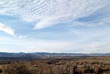
Downtown Lander, 2008 | ||
| ||
| Motto: "Real. Western. Spirit." | ||
 Location of Lander, Wyoming | ||
 Lander, Wyoming Location in the United States | ||
| Coordinates: 42°49′59″N 108°43′57″W / 42.83306°N 108.73250°WCoordinates: 42°49′59″N 108°43′57″W / 42.83306°N 108.73250°W | ||
| Country | United States | |
| State | Wyoming | |
| County | Fremont | |
| Area[1] | ||
| • Total | 4.67 sq mi (12.10 km2) | |
| • Land | 4.67 sq mi (12.10 km2) | |
| • Water | 0 sq mi (0 km2) | |
| Elevation | 5,358 ft (1,633 m) | |
| Population (2010)[2] | ||
| • Total | 7,487 | |
| • Estimate (2012[3]) | 7,677 | |
| • Density | 1,603.2/sq mi (619.0/km2) | |
| Time zone | Mountain (MST) (UTC-7) | |
| • Summer (DST) | MDT (UTC-6) | |
| ZIP code | 82520 | |
| Area code(s) | 307 | |
| FIPS code | 56-44760[4] | |
| GNIS feature ID | 1609112[5] | |
| Website | City of Lander Wyoming | |

Lander is a city in, and the county seat of, Fremont County, Wyoming, United States. Named for transcontinental explorer Frederick W. Lander,[6] Lander is located in central Wyoming, along the Middle Fork of the Popo Agie River. A tourism center with several dude ranches nearby, Lander is located just south of the Wind River Indian Reservation. The population was 7,487 at the 2010 census.
History
Lander was known as Pushroot, Fort Brown, and Fort Auger prior to its current name. The town was named Lander in honor of General Frederick W. Lander, a famous transcontinental explorer who surveyed the Oregon Trail's Lander Cutoff.[7] Several miles southeast of town near present-day U.S. Route 287 is the site of Wyoming's first oil well, circa 1884.[8] The town was incorporated in 1890.[9]
On October 1, 1906, Lander became the westward terminus of the "Cowboy Line" of the Chicago and North Western Railway, thus originating the slogan "where rails end and trails begin." Originally intended to be a transcontinental mainline to Coos Bay, Oregon, or Eureka, California, the line never went further west, and service to Lander was abandoned in 1972.[10]
Lander is where the first paid rodeo took place, which continues to this day in coordination with the town's raucous Fourth of July festivities.[9]
Geography
Lander is located at 42°49′59″N 108°43′57″W / 42.83306°N 108.73250°W (42.833035, −108.732633).[11]
According to the United States Census Bureau, the city has a total area of 4.67 square miles (12.10 km2), all of it land.[1]
Climate
As with much of the state, Lander experiences a semi-arid climate (Köppen BSk) with cold, dry winters and hot, wetter summers.
| Climate data for Lander, Wyoming (1981–2010 normals, extremes 1891–present) | |||||||||||||
|---|---|---|---|---|---|---|---|---|---|---|---|---|---|
| Month | Jan | Feb | Mar | Apr | May | Jun | Jul | Aug | Sep | Oct | Nov | Dec | Year |
| Record high °F (°C) | 64 (18) |
68 (20) |
76 (24) |
83 (28) |
93 (34) |
100 (38) |
102 (39) |
101 (38) |
94 (34) |
86 (30) |
72 (22) |
65 (18) |
102 (39) |
| Average high °F (°C) | 33.1 (0.6) |
36.5 (2.5) |
47.4 (8.6) |
56.4 (13.6) |
66.5 (19.2) |
77.5 (25.3) |
86.8 (30.4) |
85.0 (29.4) |
72.8 (22.7) |
58.5 (14.7) |
42.8 (6) |
31.8 (−0.1) |
57.92 (14.41) |
| Average low °F (°C) | 10.2 (−12.1) |
13.9 (−10.1) |
23.6 (−4.7) |
31.3 (−0.4) |
40.1 (4.5) |
48.4 (9.1) |
55.6 (13.1) |
54.3 (12.4) |
44.4 (6.9) |
32.7 (0.4) |
19.7 (−6.8) |
9.6 (−12.4) |
31.98 (−0.01) |
| Record low °F (°C) | −39 (−39) |
−40 (−40) |
−24 (−31) |
−11 (−24) |
13 (−11) |
25 (−4) |
32 (0) |
23 (−5) |
7 (−14) |
−14 (−26) |
−31 (−35) |
−40 (−40) |
−40 (−40) |
| Average precipitation inches (mm) | .41 (10.4) |
.58 (14.7) |
1.16 (29.5) |
1.87 (47.5) |
2.20 (55.9) |
1.28 (32.5) |
.78 (19.8) |
.61 (15.5) |
1.05 (26.7) |
1.29 (32.8) |
.86 (21.8) |
.58 (14.7) |
12.65 (321.3) |
| Average snowfall inches (cm) | 7.6 (19.3) |
10.3 (26.2) |
16.1 (40.9) |
16.8 (42.7) |
4.8 (12.2) |
0.1 (0.3) |
0 (0) |
0 (0) |
2.7 (6.9) |
9.8 (24.9) |
13.1 (33.3) |
10.1 (25.7) |
91.4 (232.4) |
| Average precipitation days (≥ 0.01 in) | 3.9 | 5.1 | 6.7 | 8.0 | 8.2 | 6.3 | 5.9 | 5.4 | 6.0 | 5.6 | 5.2 | 4.5 | 70.8 |
| Average snowy days (≥ 0.1 in) | 4.3 | 5.2 | 5.8 | 5.2 | 1.6 | 0.1 | 0 | 0 | 0.9 | 3.5 | 5.0 | 5.1 | 36.7 |
| Mean monthly sunshine hours | 192.2 | 203.4 | 257.3 | 270.0 | 294.5 | 330.0 | 347.2 | 328.6 | 273.0 | 232.5 | 174.0 | 173.6 | 3,076.3 |
| Source: NOAA,[12] HKO (sun only, 1961−1990)[13] | |||||||||||||
Demographics
| Historical population | |||
|---|---|---|---|
| Census | Pop. | %± | |
| 1880 | 193 | — | |
| 1890 | 525 | 172.0% | |
| 1900 | 737 | 40.4% | |
| 1910 | 1,812 | 145.9% | |
| 1920 | 2,133 | 17.7% | |
| 1930 | 1,826 | −14.4% | |
| 1940 | 2,594 | 42.1% | |
| 1950 | 3,349 | 29.1% | |
| 1960 | 4,182 | 24.9% | |
| 1970 | 7,125 | 70.4% | |
| 1980 | 7,867 | 10.4% | |
| 1990 | 7,023 | −10.7% | |
| 2000 | 6,867 | −2.2% | |
| 2010 | 7,487 | 9.0% | |
| Est. 2015 | 7,686 | [14] | 2.7% |
2010 census
As of the census[2] of 2010, there were 7,487 people, 3,161 households, and 1,932 families residing in the city. The population density was 1,603.2 inhabitants per square mile (619.0/km2). There were 3,385 housing units at an average density of 724.8 per square mile (279.8/km2). The racial makeup of the city was 88.0% White, 0.2% African American, 7.3% Native American, 0.6% Asian, 1.0% from other races, and 2.9% from two or more races. Hispanic or Latino of any race were 4.8% of the population.
There were 3,161 households of which 28.3% had children under the age of 18 living with them, 46.2% were married couples living together, 10.9% had a female householder with no husband present, 4.0% had a male householder with no wife present, and 38.9% were non-families. 32.0% of all households were made up of individuals and 13% had someone living alone who was 65 years of age or older. The average household size was 2.30 and the average family size was 2.85.
The median age in the city was 40.3 years. 22.4% of residents were under the age of 18; 8% were between the ages of 18 and 24; 25.3% were from 25 to 44; 27.3% were from 45 to 64; and 17% were 65 years of age or older. The gender makeup of the city was 49.0% male and 51.0% female.
2000 census
As of the census[4] of 2000, there were 6,867 people, 2,794 households, and 1,824 families residing in the city. The population density was 1,554.0 people per square mile (599.9/km²). There were 3,036 housing units at an average density of 687.0 per square mile (265.2/km²). The racial makeup of the city was 90.81% White, 0.15% African American, 5.99% Native American, 0.32% Asian, 0.70% from other races, and 2.04% from two or more races. Hispanic or Latino of any race were 3.48% of the population.
There were 2,794 households out of which 30.4% had children under the age of 18 living with them, 51.5% were married couples living together, 10.1% had a female householder with no husband present, and 34.7% were non-families. 30.0% of all households were made up of individuals and 12.5% had someone living alone who was 65 years of age or older. The average household size was 2.34 and the average family size was 2.91.
In the city the population was spread out with 24.1% under the age of 18, 7.1% from 18 to 24, 26.7% from 25 to 44, 25.5% from 45 to 64, and 16.6% who were 65 years of age or older. The median age was 40 years. For every 100 females there were 95.4 males. For every 100 females age 18 and over, there were 89.2 males.
The median income for a household in the city was $32,397, and the median income for a family was $41,958. Males had a median income of $30,602 versus $20,916 for females. The per capita income for the city was $18,389. About 9.9% of families and 13.2% of the population were below the poverty line, including 19.3% of those under age 18 and 9.3% of those age 65 or over.
Economy
Present day Lander is home to numerous State and Federal government offices, including the U.S. Forest Service (Washakie Ranger District, Shoshone National Forest), the Bureau of Land Management (Lander Field Office), the U.S. Fish and Wildlife Service, and a Resident Agency of the Denver Field Office of the FBI, as well as the Wyoming Life Resource Center[16] and the Wyoming Department of Environmental Quality. One of the country's major bronze foundries, Eagle Bronze, is located in Lander, as is the International Headquarters of the National Outdoor Leadership School and other environment and land-related non profit organizations including offices of the Wyoming Outdoor Council, the Wyoming office of The Nature Conservancy, the Wyoming Wildlife Federation, and Wyoming Catholic College.
In addition to the public sector and a traditional agriculture and grazing economy, the economy of Lander and the region are supported by substantial tourism. Located at the foot of the Wind River Mountains, Lander serves as a point of departure for camping, hunting, fishing, wilderness travel, climbing, and mountaineering. In addition to the wilderness climbing and mountaineering opportunities in the Wind River Range, rock climbing areas close to town (most prominently, Sinks Canyon and "Wild Iris," located at Limestone Mountain) attract significant numbers of rock climbers to Lander.
The town is one of the headquarters of Asthmatic Kitty Records, founded by Sufjan Stevens.
Arts and culture
The Lander Art Center downtown displays rotating art exhibits, holds biannual art fairs, and hosts varying art classes.[17] The work of William Shakespeare is performed by the touring Wyoming Shakespeare Festival Company, a non-profit organization based out of Lander. The Lander Community Concerts Association has brought in various performing artists since 1947.[18] Lander's local library is the main branch of the Fremont County Library System,[19] the original local Carnegie library still stands as part of the current building.
Annual cultural events
The Pioneer Days Parade and Rodeo takes place on July 3rd and 4th every year. The Lander Brew Festival features samples from Rocky Mountain-area breweries and has been held since 2002. Other annual events include the Wyoming State Winter Fair, the International Climbers Festival, and the Annual One Shot Antelope Hunt.[20]
Attractions

Outdoor attractions near Lander include Sinks Canyon State Park, Shoshone National Forest, the Wind River Mountains, and the Red Desert. Additionally, Lander is home to a number of museums, including the Fremont County Pioneer Museum, which focuses on the history of the Lander area; the Museum of the American West, which maintains a complex of historic structures; the Lander Children’s Museum, with hands-on exhibits; and the Evans Dahl Memorial Museum, dedicated to the Annual One Shot Antelope Hunt.[21]
Government
Since 1998, Lander and Fremont County have been represented in the Wyoming State Senate by economist/businessman Cale Case, a Republican.
Education
Public education
Public education in the city of Lander is provided by Fremont County School District #1. Lander Valley High School is the main high school. It is located just west of Main Street after the demolition of the historic high school. Despite attempts to preserve the school the land was sold and is now a business complex. Pathfinder is the alternative high school.
Wyoming Catholic College
In 2007, Wyoming Catholic College, a four-year, coeducational, private college was founded in Lander. The college was only the second four-year brick and mortar institution of higher education ever in Wyoming. It was designed to give students a general liberal arts education via a Great Books curriculum, while allowing them to develop morally and spiritually in a small Catholic community. It uses an Outdoor Adventure Program to take students into the nearby Wind River Mountains to teach leadership, decision-making skills, and to ignite their imaginations. The college received its Apostolic Blessing in 2005 from Most Reverend David L. Ricken, DD, JCL, the Bishop of Cheyenne. At present, Wyoming Catholic College has achieved pre-accreditation through The American Academy for Liberal Education[22] and has achieved candidate status by the Higher Learning Commission .
National Outdoor Leadership School
The National Outdoor Leadership School (NOLS) was founded in Lander and is headquartered in the city. Its Rocky Mountain branch operates out of Lander. NOLS operates the Noble Hotel on Main Street for its instructors, students and alumni.
Infrastructure
Health care
The Wyoming Department of Health Wyoming Life Resource Center (WLRC), originally the Wyoming State Training School (WSTS), a residential facility for physically and mentally disabled people, is located in Lander.[23][24] The facility was operated by the Wyoming Board of Charities and Reform until that agency was dissolved as a result of a state constitutional amendment passed in November 1990.[25]
Postal service
The United States Postal Service operates the Lander Post Office.[26]
Airline service
Scheduled passenger airline service is available via the nearby Riverton Regional Airport located near Riverton, Wyoming.
Notable people
- Clayton Danks, the model of the cowboy on the Wyoming state trademark, the Bucking Horse and Rider, is interred at Mount Hope Cemetery in Lander.[27]
- Larry LaRose, NASA Flight Engineer, Shuttle Training Aircraft, Shuttle carrier Associate, is a native of Lander.
- Nate Marquardt, a Mixed Martial Artist and current Welterweight in the UFC, was born in Lander.
- Joseph B. Meyer, Wyoming attorney general and state treasurer was an assistant county attorney in Lander early in his political career.
- Bob Nicholas, Wyoming State representative from District 8 in Cheyenne, is a native of Lander.
References
- 1 2 "US Gazetteer files 2010". United States Census Bureau. Archived from the original on 2012-01-24. Retrieved 2012-12-14.
- 1 2 "American FactFinder". United States Census Bureau. Retrieved 2012-12-14.
- ↑ "Population Estimates". United States Census Bureau. Archived from the original on 2013-06-17. Retrieved 2013-06-01.
- 1 2 "American FactFinder". United States Census Bureau. Archived from the original on 2013-09-11. Retrieved 2008-01-31.
- ↑ "US Board on Geographic Names". United States Geological Survey. 2007-10-25. Retrieved 2008-01-31.
- ↑ "Find a County". National Association of Counties. Archived from the original on 2011-05-31. Retrieved 2011-06-07.
- ↑ "Profile for Lander, Wyoming, WY". ePodunk. Retrieved July 21, 2012.
- ↑ Official State Highway Map of Wyoming (Map). Wyoming Department of Transportation. 2014.
- 1 2 "Lander Wyoming". Sangres.com. Retrieved July 21, 2012.
- ↑ Timeline
- ↑ "US Gazetteer files: 2010, 2000, and 1990". United States Census Bureau. 2011-02-12. Retrieved 2011-04-23.
- ↑ "NowData - NOAA Online Weather Data". National Oceanic and Atmospheric Administration. Retrieved 2013-07-02.
- ↑ "Climatological Normals of Lander". Hong Kong Observatory. Retrieved 2014-03-09.
- ↑ "Annual Estimates of the Resident Population for Incorporated Places: April 1, 2010 to July 1, 2015". Retrieved July 2, 2016.
- ↑ "Census of Population and Housing". Census.gov. Archived from the original on May 11, 2015. Retrieved June 4, 2015.
- ↑ http://wdh.state.wy.us/wlrc/index.html[]
- ↑ "About the Lander Art Center". Lander Art Center. Retrieved 2014-08-22.
- ↑ "Arts/Music/Theatre". Lander Chamber of Commerce. Retrieved 2014-08-22.
- ↑ "Fremont County Library System". Fremont County Library System. Retrieved 2014-08-22.
- ↑ "Festivals & Entertainment". Lander Chamber of Commerce. Retrieved 2014-08-22.
- ↑ "Museums & Historic Sites". Lander Chamber of Commerce. Retrieved 2014-08-22.
- ↑ "Wyoming Catholic College". Wyoming Catholic College. Retrieved 2008-03-27.
- ↑ "WDH Who We Are - Wyoming Life Resource Center." Wyoming Department of Health. Retrieved on December 12, 2010.
- ↑ "Lander city, Wyoming." U.S. Census Bureau. Retrieved on December 12, 2010.
- ↑ "About the Department of Corrections." Wyoming Department of Corrections. Retrieved on August 22, 2010.
- ↑ "Post Office Location - LANDER." United States Postal Service. Retrieved on December 12, 2010.
- ↑ "Clarence Clayton Danks". findagrave.com. Retrieved September 23, 2013.
External links
 Media related to Lander, Wyoming at Wikimedia Commons
Municipalities and communities of Fremont County, Wyoming, United States | ||
|---|---|---|
| Cities |  | |
| Towns | ||
| CDPs | ||
| Unincorporated communities | ||
| Ghost town | ||
| Indian reservation | ||
Cheyenne (capital) | |
| Topics |
|
| Society |
|
| Regions | |
| Cities | |
| Counties | |