Chaghcharan
| Chaghcharan چغچران | |
|---|---|
 Chaghcharan Location in Afghanistan | |
| Coordinates: 34°31′21″N 65°15′6″E / 34.52250°N 65.25167°ECoordinates: 34°31′21″N 65°15′6″E / 34.52250°N 65.25167°E | |
| Country |
|
| Province | Ghor Province |
| Elevation | 2,230 m (7,320 ft) |
| Population | |
| • City | 15,000 |
| • Urban | 31,266 [1] |
| Time zone | UTC+4:30 |
Chaghcharān (/tʃæɡtʃæˈrɑːn/; Persian: چغچران), also called Chakhcheran, and formerly known as Āhangarān Pashto: آهنګران), (Persian: آهنگران, is a town and district in central Afghanistan, which serves as the capital of Ghor Province. It is located on the southern side of the Hari River, at an altitude of 2,230 m above sea level. In 2014, the Government of Afghanistan formally changed the name of this town to Firuzkoh.
Chaghcharan is linked by a 380-kilometre-long highway with Herat to the west and is about the same distance from Kabul to the east and is also served by Chaghcharan Airport.
It has a population of about 15,000 who are mostly Dari speakers. However the recent data showed a population of 31,266 (in 2015). [2] it has 1 districts and a total land area of 2,614 Hectares. [3] The total number of dwellings in this city are 3,474.[4]
History
Medieval
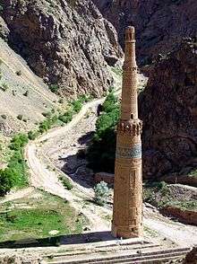
Prior to the arrival of Islam the region's inhabitants practiced various different religions including Zoroastrianism, Buddhism, Judaism. The Islamic conquest of Afghanistan by Sultan Mahmud of Ghazni took place in the 10th century. After the defeat of the Ghaznavids in the 12th century the area came under the control of the local Ghurid dynasty of Ghor. The Ghurid Dynasty had its summer capital, Firozkoh nearby and they constructed the Minaret of Jam there. Today the Minaret of Jam is a UNESCO World Heritage site.
In the 13th century, the Ghor region was invaded by the Mongol army who destroyed Firozkoh but left the Minaret of Jam intact. It was then ruled by the Ilkhanate until Timur conquered it in the 14th century.
Chakhcherān is mentioned by name in the 16th century Baburnama, describing Babur's visit in early 1507 while on his journey to Kabul. It was a town located in the Gharjistan region, between Herat, Ghor, and Ghazni.[5]
Modern Era
.jpg)

In 2004, an independent FM radio station (Persian: راديو صداي صلح or Voice of Peace Radio) came on air in the town, the first independent media in this part of Afghanistan.
In June 2005, the International Security Assistance Force (ISAF) established a Lithuanian led Provincial Reconstruction Team in which Croatian, Danish, American, Ukrainian, Icelandic, and Georgian troops also served.
Demography
Approximately 15,000 people live in the town, making it the largest in the province. However this city population is estimated to be 31,266 in 2015.[6] The main inhabitants of Chaghcharan are Aimaq, Hazaras and Tajiks.[7]
Land Use
Chaghcharan (Ferozkoh) is located at the central region of Afghanistan connected by a highway 380 km West to Herat and about the same East to Kabul.[8] Ferozkoh is an ancient city that date back to Genghis Khan and Mongols. Ferozkoh is famous for agriculture and animal husbandry.[9]
Transportation
As of August 2015, Chaghcharan Airport, located northwest of the Hari River, one mile northeast of Chaghcharan, had regularly scheduled flights to Kabul and Herat. However, as of January 2016 commercial operators no longer offer scheduled flights, leaving the United Nations Humanitarian Air Service (UNHAS) as the only user of Chaghcharan Airport with flights to Kabul and Herat.
The main road from Changhcharan runs toward Herat in the west and Kabul in the east. Due to severe weather, the road is often closed during winter and even in summer it can take three full days to drive from Chagcharan to Kabul.
Economy
Agriculture and animal husbandry are the primary economic activities in Ghor Province.[10]
Climate
Chaghcharan has a cool-summer humid continental climate (Köppen Dsb), with snowy winters and cool, dry summers. Precipitation is low, and mostly falls in winter and spring.
| Climate data for Chaghcharān | |||||||||||||
|---|---|---|---|---|---|---|---|---|---|---|---|---|---|
| Month | Jan | Feb | Mar | Apr | May | Jun | Jul | Aug | Sep | Oct | Nov | Dec | Year |
| Record high °C (°F) | 12.0 (53.6) |
11.5 (52.7) |
20.6 (69.1) |
26.8 (80.2) |
32.3 (90.1) |
34.6 (94.3) |
37.4 (99.3) |
35.0 (95) |
33.0 (91.4) |
27.5 (81.5) |
21.0 (69.8) |
16.7 (62.1) |
37.4 (99.3) |
| Average high °C (°F) | −1.3 (29.7) |
0.0 (32) |
8.8 (47.8) |
17.4 (63.3) |
21.8 (71.2) |
27.3 (81.1) |
29.8 (85.6) |
28.8 (83.8) |
24.7 (76.5) |
17.9 (64.2) |
11.4 (52.5) |
3.2 (37.8) |
15.82 (60.46) |
| Daily mean °C (°F) | −9.4 (15.1) |
−7.3 (18.9) |
1.6 (34.9) |
9.3 (48.7) |
12.8 (55) |
17.2 (63) |
19.3 (66.7) |
17.8 (64) |
12.4 (54.3) |
6.9 (44.4) |
1.5 (34.7) |
−4.4 (24.1) |
6.48 (43.65) |
| Average low °C (°F) | −16.3 (2.7) |
−15.3 (4.5) |
−3.9 (25) |
2.1 (35.8) |
3.5 (38.3) |
4.9 (40.8) |
7.1 (44.8) |
5.3 (41.5) |
−0.2 (31.6) |
−2.8 (27) |
−6.8 (19.8) |
−11.1 (12) |
−2.79 (26.98) |
| Record low °C (°F) | −44 (−47) |
−46.0 (−50.8) |
−26 (−15) |
−10.8 (12.6) |
−6.0 (21.2) |
−2.7 (27.1) |
0.5 (32.9) |
−2.0 (28.4) |
−8.0 (17.6) |
−14.6 (5.7) |
−19.5 (−3.1) |
−35 (−31) |
−46 (−50.8) |
| Average precipitation mm (inches) | 30.9 (1.217) |
32.2 (1.268) |
40.0 (1.575) |
35.3 (1.39) |
20.1 (0.791) |
0.4 (0.016) |
0.1 (0.004) |
0.5 (0.02) |
0.0 (0) |
11.0 (0.433) |
15.8 (0.622) |
18.1 (0.713) |
204.4 (8.049) |
| Average rainy days | 0 | 1 | 6 | 8 | 5 | 0 | 0 | 0 | 0 | 3 | 3 | 1 | 27 |
| Average snowy days | 8 | 9 | 5 | 1 | 0 | 0 | 0 | 0 | 0 | 0 | 2 | 7 | 32 |
| Average relative humidity (%) | 70 | 71 | 66 | 56 | 49 | 39 | 34 | 32 | 36 | 44 | 54 | 64 | 51.3 |
| Mean monthly sunshine hours | 146.4 | 150.2 | 198.6 | 223.9 | 320.6 | 383.9 | 389.4 | 358.0 | 344.7 | 267.7 | 217.9 | 154.7 | 3,156 |
| Source: NOAA (1968-1983) [11] | |||||||||||||
See also
References and footnotes
- ↑ "The State of Afghan Cities report 2015".
- ↑ "The State of Afghan Cities report2015".
- ↑ "The State of Afghan Cities report 2015".
- ↑ "The State of Afghan Cities report2015".
- ↑ Zahir ud-Din Mohammad Babur (1507). "Events Of The Year 912". Memoirs of Babur. Packard Humanities Institute. Retrieved 2011-08-18.
- ↑ "The State of Afghan Cities report 2015".
- ↑ http://www.aims.org.af/afg/dist_profiles/unhcr_district_profiles/western/ghor/chaghcharan.pdf[]
- ↑ "The State of Afghan Cities report 2015".
- ↑ "The State of Afghan Cities report 2015".
- ↑ Ghor Province by Naval Postgraduate School, http://www.nps.edu/Programs/CCS/Ghor/Ghor.html
- ↑ "Chakhcharan Climate Normals 1968-1983". National Oceanic and Atmospheric Administration. Retrieved December 26, 2012.
External links
| Wikimedia Commons has media related to Chaghcharan. |
- Dupree, Nancy Hatch (1977): An Historical Guide to Afghanistan. 1st Edition: 1970. 2nd Edition. Revised and Enlarged. Afghan Tourist Organization. (Chapter 32 - Chakhcharan to Herat)