Chama, New Mexico
| Chama, New Mexico | |
|---|---|
| Village | |
|
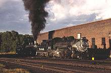
Cumbres & Toltec train in downtown Chama | |
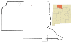 Location of Chama, New Mexico | |
 Chama, New Mexico Location in the United States | |
| Coordinates: 36°53′41″N 106°35′4″W / 36.89472°N 106.58444°WCoordinates: 36°53′41″N 106°35′4″W / 36.89472°N 106.58444°W | |
| Country | United States |
| State | New Mexico |
| County | Rio Arriba |
| Government | |
| • Mayor | Matt Dillon |
| Area | |
| • Total | 2.6 sq mi (6.6 km2) |
| • Land | 2.6 sq mi (6.6 km2) |
| • Water | 0.0 sq mi (0.0 km2) |
| Elevation | 7,871 ft (2,399 m) |
| Population (2000) | |
| • Total | 1,199 |
| • Density | 467.9/sq mi (180.6/km2) |
| Time zone | Mountain (MST) (UTC-7) |
| • Summer (DST) | MDT (UTC-6) |
| ZIP code | 87520 |
| Area code(s) | 575 |
| FIPS code | 35-13970 |
| GNIS feature ID | 0902207 |
| Website | http://chamavillage.com/ |

Chama is a village in Rio Arriba County, New Mexico, United States. The population was 1,199 at the 2000 census.
Geography
Chama is located at 36°53′41″N 106°35′4″W / 36.89472°N 106.58444°W (36.894777, -106.584406),[1] on the Rio Chama. According to the United States Census Bureau, the village has a total area of 2.6 square miles (6.7 km2), all of it land.
Transportation heritage
Chama is the western terminus of the Cumbres and Toltec Scenic Railroad, a steam-driven, narrow gauge heritage railway which carries visitors to and from Osier, Colorado, and Antonito, Colorado, during the summer months. It is the remaining 64 mile portion of the Denver & Rio Grande Railroad's San Juan Extension built in the 1880s between Alamosa, Colorado, and Durango, Colorado. The route was abandoned in the late 1960s and the tracks from Chama westward to Durango were torn up soon afterwards.
Demographics
| Historical population | |||
|---|---|---|---|
| Census | Pop. | %± | |
| 1970 | 899 | — | |
| 1980 | 1,090 | 21.2% | |
| 1990 | 1,048 | −3.9% | |
| 2000 | 1,199 | 14.4% | |
| 2010 | 1,022 | −14.8% | |
| Est. 2015 | 1,004 | [2] | −1.8% |
At the 2000 census,[4] there were 1,199 people, 467 households and 312 families residing in the village. The population density was 467.9 per square mile (180.8/km²). There were 601 housing units at an average density of 234.5 per square mile (90.6/km²). The racial makeup of the village was 67.56% White, 1.58% African American, 2.67% Native American, 0.08% Asian, 25.10% from other races, and 3.00% from two or more races. Hispanic or Latino of any race were 71.23% of the population.
There were 467 households of which 30.8% had children under the age of 18 living with them, 49.5% were married couples living together, 12.0% had a female householder with no husband present, and 33.0% were non-families. 26.3% of all households were made up of individuals and 8.8% had someone living alone who was 65 years of age or older. The average household size was 2.57 and the average family size was 3.13.
26.6% of the population were under the age of 18, 6.7% from 18 to 24, 26.3% from 25 to 44, 28.2% from 45 to 64, and 12.3% who were 65 years of age or older. The median age was 38 years. For every 100 females there were 95.9 males. For every 100 females age 18 and over, there were 90.1 males.
The median household income was $30,513, and the median family income was $31,983. Males had a median income of $27,167 compared with $20,054 for females. The per capita income for the village was $16,670. About 11.9% of families and 17.9% of the population were below the poverty line, including 28.6% of those under age 18 and 13.7% of those age 65 or over.
Climate
This climatic region is typified by large seasonal temperature differences, with warm to hot (and often humid) summers and cold (sometimes severely cold) winters. According to the Köppen Climate Classification system, Chama has a humid continental climate, abbreviated "Dfb" on climate maps.[5]
| Climate data for Chama, New Mexico | |||||||||||||
|---|---|---|---|---|---|---|---|---|---|---|---|---|---|
| Month | Jan | Feb | Mar | Apr | May | Jun | Jul | Aug | Sep | Oct | Nov | Dec | Year |
| Average high °C (°F) | 3 (38) |
5 (41) |
8 (47) |
14 (57) |
19 (66) |
25 (77) |
27 (81) |
26 (78) |
22 (72) |
17 (62) |
9 (49) |
4 (39) |
16 (60) |
| Average low °C (°F) | −14 (6) |
−12 (10) |
−9 (16) |
−4 (24) |
0 (32) |
4 (39) |
8 (46) |
8 (46) |
3 (38) |
−2 (28) |
−8 (18) |
−13 (9) |
−3 (26) |
| Average precipitation cm (inches) | 5 (2) |
4.6 (1.8) |
4.8 (1.9) |
3.6 (1.4) |
3.3 (1.3) |
2.3 (0.9) |
5.6 (2.2) |
7.1 (2.8) |
5 (2) |
4.3 (1.7) |
3.6 (1.4) |
4.6 (1.8) |
54.4 (21.4) |
| Source: Weatherbase [6] | |||||||||||||
See also
References
- ↑ "US Gazetteer files: 2010, 2000, and 1990". United States Census Bureau. 2011-02-12. Retrieved 2011-04-23.
- ↑ "Annual Estimates of the Resident Population for Incorporated Places: April 1, 2010 to July 1, 2015". Retrieved July 2, 2016.
- ↑ "Census of Population and Housing". Census.gov. Archived from the original on May 11, 2015. Retrieved June 4, 2015.
- ↑ "American FactFinder". United States Census Bureau. Archived from the original on 2013-09-11. Retrieved 2008-01-31.
- ↑ Climate Summary for Chama, New Mexico
- ↑ "Weatherbase.com". Weatherbase. 2013. Retrieved on October 3, 2013.
External links
| Wikivoyage has a travel guide for Chama. |
Municipalities and communities of Rio Arriba County, New Mexico, United States | ||
|---|---|---|
| City | 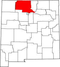 | |
| Village | ||
| CDPs |
| |
| Other unincorporated communities | ||
| Ghost towns and former settlements | ||
| Indian reservation | ||
| Footnotes | ‡This populated place also has portions in an adjacent county or counties | |