Col du Lautaret
| Col du Lautaret | |
|---|---|
|
Route Nationale 91 at Col du Lautaret | |
| Elevation | 2,057 m (6,749 ft)[1] |
| Traversed by | Route nationale 91 |
| Location | Hautes-Alpes, France |
| Range | French Alps |
| Coordinates | 45°02′04″N 06°24′18″E / 45.03444°N 6.40500°ECoordinates: 45°02′04″N 06°24′18″E / 45.03444°N 6.40500°E |
 Location of Col du Lautaret | |
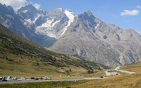

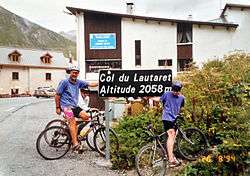
Col du Lautaret (2,057 m (6,749 ft)) is a high mountain pass in the department of Hautes-Alpes in France.
It marks the boundary between the valleys of the Romanche and the Guisane, a tributary of the Durance which has its source at the col. The valleys are linked by national route 91 (Grenoble – Le Bourg-d'Oisans – Briançon). The Lautaret is one of the lowest points on the ridge line which separates the "north" (mainly in the Rhône-Alpes région) and "south" (mainly in the Provence-Alpes-Côte d'Azur région) geographic areas of the French Alps.
The Col has long been used as a communication route between Grenoble and Briançon, and indeed for reaching Italy across the Alps.
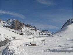
The Col is open all year round and provides good views of La Meije to the south-west and the Grand Galibier to the north. It is also well known for its botanical garden. The route to the south side of the Col du Galibier leaves from the Lautaret.
Cycle racing
Details of the climbs
From the west, the climb starts at Les Clapier, near Le Bourg-d'Oisans, from where the climb is 34.2 km (21.3 mi) long, gaining 1,312 m (4,304 ft) in altitude, at an average gradient of 3.8%, with the steepest section being at 7.5% in the first kilometre.[2]
The eastern approach commences at Briançon, from where there is 27.7 km (17.2 mi) to the summit, gaining 853 m (2,799 ft) in altitude, at an average gradient of 3.1%, with a maximum of 5.2%.[3]
Tour de France
The Tour de France first crossed over the Col du Lautaret in 1911, when the leader over the summit was Émile Georget.[4] Since 1947, the Lautaret pass has been crossed over 40 times by the Tour de France, although most of these have not been classified for the "King of the Mountains" competition, usually when the pass is crossed on the descent from the Col du Galibier.[5]
Appearances in Tour de France
Since 1947, the passages which have been categorized have been:[5]
| Year | Stage | Category | Start | Finish | Leader at the summit |
|---|---|---|---|---|---|
| 2014 | 14 | 1 | Grenoble | Risoul | |
| 2006 | 15 | 2 | Gap | Alpe-d'Huez | |
| 2003 | 9 | 1 | Le Bourg-d'Oisans | Gap | |
| 1972 | 14a | 3 | Briançon | Valloire | |
| 1965 | 17 | 3 | Briançon | Aix-les-Bains | |
| 1962 | 19 | 3 | Briançon | Aix-les-Bains | |
| 1960 | 17 | 3 | Briançon | Aix-les-Bains | |
| 1958 | 21 | 3 | Briançon | Aix-les-Bains | |
| 1953 | 19 | 2 | Briançon | Lyon | |
| 1951 | 21 | 3 | Briançon | Aix-les-Bains | |
| 1950 | 19 | 2 | Briançon | Saint-Étienne |
References
- ↑ IGN map
- ↑ "Col du Lautaret - Le Clapier". climbbybike. Retrieved 19 July 2014.
- ↑ "Col du Lautaret - Briançon". climbbybike. Retrieved 21 July 2014.
- ↑ Woodland, Les (2003). The Yellow Jersey Companion to the Tour de France. Yellow Jersey Press. p. 263. ISBN 0-224-06318-9.
- 1 2 "Le col du Lautaret dans le Tour de France depuis 1947" (in French). ledicodutour. Retrieved 15 July 2014.
External links
| Wikimedia Commons has media related to Col du Lautaret. |