Coon Valley, Wisconsin
| Coon Valley, Wisconsin | |
|---|---|
| Village | |
|
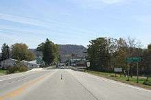
Street view of Coon Valley from Hwy. 14 | |
 Location in Vernon County and the state of Wisconsin. | |
| Coordinates: 43°42′6″N 91°0′51″W / 43.70167°N 91.01417°WCoordinates: 43°42′6″N 91°0′51″W / 43.70167°N 91.01417°W | |
| Country | United States |
| State | Wisconsin |
| County | Vernon |
| Area[1] | |
| • Total | 1.09 sq mi (2.82 km2) |
| • Land | 1.09 sq mi (2.82 km2) |
| • Water | 0 sq mi (0 km2) |
| Elevation[2] | 738 ft (225 m) |
| Population (2010)[3] | |
| • Total | 765 |
| • Estimate (2012[4]) | 780 |
| • Density | 701.8/sq mi (271.0/km2) |
| Time zone | Central (CST) (UTC-6) |
| • Summer (DST) | CDT (UTC-5) |
| Area code(s) | 608 |
| FIPS code | 55-16900[5] |
| GNIS feature ID | 1563376[2] |
| Website | http://www.villageofcoonvalley.com/ |

Coon Valley is a village in Vernon County, Wisconsin, United States. The population was 765 at the 2010 census.
Geography
Coon Valley is located at 43°42′6″N 91°0′51″W / 43.70167°N 91.01417°W (43.701628, -91.014083).[6]
According to the United States Census Bureau, the village has a total area of 1.09 square miles (2.82 km2), all of it land.[1]
Demographics
| Historical population | |||
|---|---|---|---|
| Census | Pop. | %± | |
| 1910 | 291 | — | |
| 1920 | 369 | 26.8% | |
| 1930 | 462 | 25.2% | |
| 1940 | 469 | 1.5% | |
| 1950 | 466 | −0.6% | |
| 1960 | 536 | 15.0% | |
| 1970 | 596 | 11.2% | |
| 1980 | 758 | 27.2% | |
| 1990 | 817 | 7.8% | |
| 2000 | 714 | −12.6% | |
| 2010 | 765 | 7.1% | |
| Est. 2015 | 780 | [7] | 2.0% |
2010 census
As of the census[3] of 2010, there were 765 people, 324 households, and 216 families residing in the village. The population density was 701.8 inhabitants per square mile (271.0/km2). There were 348 housing units at an average density of 319.3 per square mile (123.3/km2). The racial makeup of the village was 98.3% White, 0.1% African American, 0.7% Asian, 0.5% from other races, and 0.4% from two or more races. Hispanic or Latino of any race were 0.7% of the population.
There were 324 households of which 32.1% had children under the age of 18 living with them, 51.9% were married couples living together, 8.0% had a female householder with no husband present, 6.8% had a male householder with no wife present, and 33.3% were non-families. 26.9% of all households were made up of individuals and 14.8% had someone living alone who was 65 years of age or older. The average household size was 2.32 and the average family size was 2.81.
The median age in the village was 41.3 years. 22.7% of residents were under the age of 18; 7% were between the ages of 18 and 24; 25.4% were from 25 to 44; 23.3% were from 45 to 64; and 21.4% were 65 years of age or older. The gender makeup of the village was 52.5% male and 47.5% female.
2000 census
As of the census[5] of 2000, there were 714 people, 307 households, and 209 families residing in the village. The population density was 661.1 people per square mile (255.3/km²). There were 332 housing units at an average density of 307.4 per square mile (118.7/km²). The racial makeup of the village was 99.30% White, 0.14% Native American, 0.42% Asian, 0.14% from other races. Hispanic or Latino of any race were 0.28% of the population.
There were 307 households out of which 27.7% had children under the age of 18 living with them, 57.3% were married couples living together, 6.8% had a female householder with no husband present, and 31.9% were non-families. 28.0% of all households were made up of individuals and 16.0% had someone living alone who was 65 years of age or older. The average household size was 2.28 and the average family size was 2.78.
In the village the population was spread out with 22.4% under the age of 18, 4.8% from 18 to 24, 28.3% from 25 to 44, 23.4% from 45 to 64, and 21.1% who were 65 years of age or older. The median age was 42 years. For every 100 females there were 105.2 males. For every 100 females age 18 and over, there were 97.2 males.
The median income for a household in the village was $36,458, and the median income for a family was $45,962. Males had a median income of $31,736 versus $21,176 for females. The per capita income for the village was $18,292. About 6.3% of families and 9.4% of the population were below the poverty line, including 15.5% of those under age 18 and 16.5% of those age 65 or over.
Points of interest
- Coon Valley Veterans Memorial Park
- Knutson Memorial Library, located on Main Street, is the village's public library.
- Norskedalen is located near Coon Valley.
- Skumsrud Heritage Farm is approximately one mile west of Coon Valley.
Notable residents
- Brian Rude, Vice President-External and Media Relations, Dairyland Power Cooperative,[9] served 17 years in the Wisconsin State Legislature[10][11]
- Scott Servais, baseball player (Astros, Cubs, Rockies), member 1988 U.S. Olympics Gold Medal Team, Manager of the Seattle Mariners major league baseball team.
References
- 1 2 "US Gazetteer files 2010". United States Census Bureau. Archived from the original on 2012-07-14. Retrieved 2012-11-18.
- 1 2 "US Board on Geographic Names". United States Geological Survey. 2007-10-25. Retrieved 2008-01-31.
- 1 2 "American FactFinder". United States Census Bureau. Retrieved 2012-11-18.
- ↑ "Population Estimates". United States Census Bureau. Archived from the original on 2013-06-17. Retrieved 2013-06-24.
- 1 2 "American FactFinder". United States Census Bureau. Archived from the original on 2013-09-11. Retrieved 2008-01-31.
- ↑ "US Gazetteer files: 2010, 2000, and 1990". United States Census Bureau. 2011-02-12. Retrieved 2011-04-23.
- ↑ "Annual Estimates of the Resident Population for Incorporated Places: April 1, 2010 to July 1, 2015". Retrieved July 2, 2016.
- ↑ "Census of Population and Housing". Census.gov. Archived from the original on May 11, 2015. Retrieved June 4, 2015.
- ↑ http://www.dairynet.com/dcontent/article/Rudepromotion.pdf
- ↑ http://www.dairynet.com/who_we_are/brianrude.php
- ↑ Wisconsin Historical Society. "Term: Rude, Brian D. 1955". Dictionary of Wisconsin History. Retrieved 2009-04-26.
Municipalities and communities of Vernon County, Wisconsin, United States | ||
|---|---|---|
| Cities | 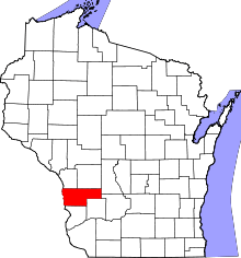 | |
| Villages | ||
| Towns | ||
| Unincorporated communities | ||
| Footnotes | ‡This populated place also has portions in an adjacent county or counties | |