Readstown, Wisconsin
| Readstown, Wisconsin | |
|---|---|
| Village | |
|
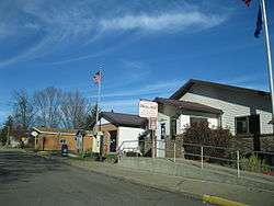
Readstown Municipal Building and post office | |
 Location in Vernon County and the state of Wisconsin. | |
| Coordinates: 43°26′55″N 90°45′39″W / 43.44861°N 90.76083°WCoordinates: 43°26′55″N 90°45′39″W / 43.44861°N 90.76083°W | |
| Country | United States |
| State | Wisconsin |
| County | Vernon |
| Area[1] | |
| • Total | 1.79 sq mi (4.64 km2) |
| • Land | 1.77 sq mi (4.58 km2) |
| • Water | 0.02 sq mi (0.05 km2) |
| Elevation[2] | 761 ft (232 m) |
| Population (2010)[3] | |
| • Total | 415 |
| • Estimate (2012[4]) | 423 |
| • Density | 234.5/sq mi (90.5/km2) |
| Time zone | Central (CST) (UTC-6) |
| • Summer (DST) | CDT (UTC-5) |
| Area code(s) | 608 |
| FIPS code | 55-66450[5] |
| GNIS feature ID | 1572122[2] |
Readstown is a village in Vernon County, Wisconsin, United States. The population was 415 at the 2010 census.
Geography
Readstown is located at 43°26′55″N 90°45′39″W / 43.44861°N 90.76083°W (43.448544, -90.760708).[6]
According to the United States Census Bureau, the village has a total area of 1.79 square miles (4.64 km2), of which, 1.77 square miles (4.58 km2) of it is land and 0.02 square miles (0.05 km2) is water.[1]
Demographics
| Historical population | |||
|---|---|---|---|
| Census | Pop. | %± | |
| 1900 | 403 | — | |
| 1910 | 515 | 27.8% | |
| 1920 | 546 | 6.0% | |
| 1930 | 544 | −0.4% | |
| 1940 | 584 | 7.4% | |
| 1950 | 541 | −7.4% | |
| 1960 | 469 | −13.3% | |
| 1970 | 395 | −15.8% | |
| 1980 | 396 | 0.3% | |
| 1990 | 420 | 6.1% | |
| 2000 | 395 | −6.0% | |
| 2010 | 415 | 5.1% | |
| Est. 2015 | 416 | [7] | 0.2% |
2010 census
As of the census[3] of 2010, there were 415 people, 186 households, and 99 families residing in the village. The population density was 234.5 inhabitants per square mile (90.5/km2). There were 213 housing units at an average density of 120.3 per square mile (46.4/km2). The racial makeup of the village was 96.4% White, 1.4% African American, 0.2% Native American, 1.0% Asian, and 1.0% from two or more races. Hispanic or Latino of any race were 1.2% of the population.
There were 186 households of which 25.3% had children under the age of 18 living with them, 39.2% were married couples living together, 9.7% had a female householder with no husband present, 4.3% had a male householder with no wife present, and 46.8% were non-families. 38.7% of all households were made up of individuals and 23.1% had someone living alone who was 65 years of age or older. The average household size was 2.20 and the average family size was 2.99.
The median age in the village was 44.9 years. 20.7% of residents were under the age of 18; 5.5% were between the ages of 18 and 24; 24.1% were from 25 to 44; 30.7% were from 45 to 64; and 19% were 65 years of age or older. The gender makeup of the village was 46.0% male and 54.0% female.
2000 census
As of the census[5] of 2000, there were 395 people, 187 households, and 104 families residing in the village. The population density was 221.0 people per square mile (85.2/km²). There were 216 housing units at an average density of 120.8 per square mile (46.6/km²). The racial makeup of the village was 100.00% White.
There were 187 households out of which 22.5% had children under the age of 18 living with them, 41.7% were married couples living together, 8.0% had a female householder with no husband present, and 43.9% were non-families. 36.9% of all households were made up of individuals and 25.1% had someone living alone who was 65 years of age or older. The average household size was 2.11 and the average family size was 2.73.
In the village the population was spread out with 21.0% under the age of 18, 7.6% from 18 to 24, 24.3% from 25 to 44, 24.8% from 45 to 64, and 22.3% who were 65 years of age or older. The median age was 43 years. For every 100 females there were 85.4 males. For every 100 females age 18 and over, there were 80.3 males.
The median income for a household in the village was $21,250, and the median income for a family was $28,125. Males had a median income of $26,250 versus $18,889 for females. The per capita income for the village was $12,957. About 9.3% of families and 21.2% of the population were below the poverty line, including 27.8% of those under age 18 and 21.4% of those age 65 or over.
Points of interest
References
- 1 2 "US Gazetteer files 2010". United States Census Bureau. Retrieved 2012-11-18.
- 1 2 "US Board on Geographic Names". United States Geological Survey. 2007-10-25. Retrieved 2008-01-31.
- 1 2 "American FactFinder". United States Census Bureau. Retrieved 2012-11-18.
- ↑ "Population Estimates". United States Census Bureau. Retrieved 2013-06-24.
- 1 2 "American FactFinder". United States Census Bureau. Retrieved 2008-01-31.
- ↑ "US Gazetteer files: 2010, 2000, and 1990". United States Census Bureau. 2011-02-12. Retrieved 2011-04-23.
- ↑ "Annual Estimates of the Resident Population for Incorporated Places: April 1, 2010 to July 1, 2015". Retrieved July 2, 2016.
- ↑ "Census of Population and Housing". Census.gov. Retrieved June 4, 2015.
External links
Municipalities and communities of Vernon County, Wisconsin, United States | ||
|---|---|---|
| Cities | 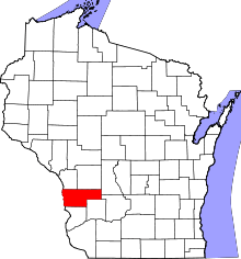 | |
| Villages | ||
| Towns | ||
| Unincorporated communities | ||
| Footnotes | ‡This populated place also has portions in an adjacent county or counties | |