Copinsay
| Norse name | Kolbeinsey |
|---|---|
| Meaning of name | "Kobeinn's Island" |
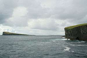 Southwards from the eastern edge of the Horse of Copinsay. Copinsay lighthouse is on the high ground in the distance. | |
| Location | |
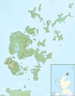 Copinsay Copinsay shown within Orkney | |
| OS grid reference | HY607015 |
| Physical geography | |
| Island group | Orkney |
| Area | 73 hectares (0.28 sq mi) |
| Area rank | 170 [1] |
| Highest elevation | 64 metres (210 ft) |
| Administration | |
| Sovereign state | United Kingdom |
| Country | Scotland |
| Council area | Orkney Islands |
| Demographics | |
| Population | 0 |
| References | [2][3][4][5][6] |
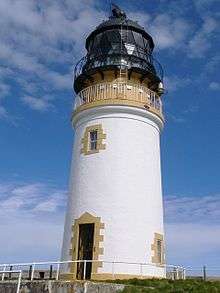 Copinsay Lighthouse in 2005 | |
| Location |
Copinsay Orkney Scotland United Kingdom |
|---|---|
| Coordinates | 58°53′47″N 2°40′19″W / 58.896432°N 2.672027°W |
| Year first constructed | 1915 |
| Automated | 1991 |
| Construction | stone tower |
| Tower shape | cylindrical tower with balcony and lantern |
| Markings / pattern | white tower, black lantern, ochre trim |
| Height | 16 metres (52 ft) |
| Focal height | 39 metres (128 ft) |
| Light source | solar power |
| Range | 21 nautical miles (39 km; 24 mi) |
| Admiralty number | A3676 |
| NGA number | 3228 |
| ARLHS number | SCO-049 |
| Managing agent |
Royal Society for the Protection of Birds [7] [8] |
Copinsay (Old Norse: Kolbeinsey) is one of the Orkney Islands in Scotland, lying off the east coast of the Orkney Mainland. The smaller companion island to Copinsay is called the Horse of Copinsay and lies to the north east to the main island. The island is now uninhabited and managed as a bird reserve. Copinsay is also home to a lighthouse.
Myths about the island include the story of the Copinsay Brownie.[9]
For many generations, prior to the final inhabitants moving to the Mainland in 1958, Copinsay was full of life; the large, double storey farmhouse and behind it the Steading (or farm buildings) form the farm tenants, a school with a schoolteacher and up to three lighthouse keepers' families.
There is also an ancient burial site on the island.
In the earlier part of the 20th century, a weekly postal service provided contact with the Mainland and fortnightly shopping trips to Deerness, allowing for weather. The farm boasted working horses, cattle and sheep - all of which had to be transported on the "coo" or "cow" boat. Birds' eggs provided a good supplement to the islanders' diet, and men were lowered over the cliffs and a special rope, or rowed out to the Horse to bring back this addition.
Pigs were loosed in the spring on the Horse for many years - feeding on the bird eggs - transported across the sound by boat.
Many interesting facts and accounts of life on Copinsay are still retold in the Deerness Community, with many members still remembering when the island was still home to loved ones.
Ecology
The island was bought by the ornithology charity, the RSPB in 1972 in memory of the naturalist James Fisher.[10] Although Copinsay today is uninhabited, some fields are still farmed at the behest of the RSPB, to try provide suitable conditions for Corncrake, so the patch work of yesteryear is returning to the island, even though the people have not. Together with the three adjacent three islets (Corn Holm, Ward Holm and Black Holm), it is designated a Special Protection Area (SPA) under the European Union directive on the Conservation of Wild Birds due to the unimproved grassland vegetation and sheer sandstone cliffs providing ideal breeding ledges for seabirds.[11] There is a large colony of grey seals on the island. They usually pup in November each year. puffins can be seen during July on the adjacent holms.
Notable Residents
Edwin Muir, a famous poet
See also
References
- ↑ Area and population ranks: there are c. 300 islands over 20 ha in extent and 93 permanently inhabited islands were listed in the 2011 census.
- ↑ 2001 UK Census per List of islands of Scotland
- ↑ Haswell-Smith, Hamish (2004). The Scottish Islands. Edinburgh: Canongate. ISBN 978-1-84195-454-7.
- ↑ Get-a-map (Map). Ordnance Survey.
- ↑ Anderson, Joseph (Ed.) (1893) Orkneyinga Saga. Translated by Jón A. Hjaltalin & Gilbert Goudie. Edinburgh. James Thin and Mercat Press (1990 reprint). ISBN 0-901824-25-9
- ↑ Pedersen, Roy (January 1992) Orkneyjar ok Katanes (map, Inverness, Nevis Print)
- ↑ Copinsay The Lighthouse Directory. University of North Carolina at Chapel Hill. Retrieved 25 May 2016
- ↑ Copinsay Northern Lighthouse Board. Retrieved 25 May 2016
- ↑ "Copinsay Brownie". Retrieved 2008-01-06.
- ↑ "Copinsay reserve". RSPB.
- ↑ "Copinsay SPA description". JNCC.
External links
| Wikimedia Commons has media related to Copinsay. |
Coordinates: 58°53′52″N 2°40′34″W / 58.89778°N 2.67611°W