Copperhill, Tennessee
| Copperhill, Tennessee | |
|---|---|
| City | |
|
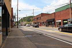
Downtown Copperhill | |
 Location of Copperhill, Tennessee | |
| Coordinates: 34°59′32″N 84°22′27″W / 34.99222°N 84.37417°W | |
| Country | United States |
| State | Tennessee |
| County | Polk |
| Founded | 1890[1] |
| Incorporated | 1913[2] |
| Area | |
| • Total | 1.9 sq mi (5.0 km2) |
| • Land | 1.9 sq mi (4.9 km2) |
| • Water | 0.0 sq mi (0.1 km2) |
| Elevation | 1,470 ft (448 m) |
| Population (2010) | |
| • Total | 354 |
| • Density | 271.9/sq mi (105.0/km2) |
| Time zone | Eastern (EST) (UTC-5) |
| • Summer (DST) | EDT (UTC-4) |
| ZIP code | 37317 |
| Area code(s) | 423 |
| FIPS code | 47-17000[3] |
| GNIS feature ID | 1281278[4] |
Copperhill is a city in Polk County, Tennessee, United States. The population was 354 at the 2010 census.[5] It is included in the Cleveland Metropolitan Statistical Area.
For years, up until the 1980s, the production of copper and acid denuded the area of any greenery, although the area has now been greatly reforested, due to a multimillion-dollar effort by the successor companies to the original copper company. The copper and acid plants have been permanently closed and most of the plant infrastructure already removed and sold overseas. Much of the scrap metals from the site have been removed and sold to China. Glenn Springs Holdings has cleaned and purified all the surrounding creeks and waterways, and water quality is now back to near pristine condition according to published EPA and Tennessee Department of Environmental Conservation studies.
The town is now a tourist attraction, with near daily rail excursions from Blue Ridge, Georgia, on the Blue Ridge Scenic Railroad. Whitewater rafting on the Ocoee River also attracts many people and other outdoor activities such as Mountain Biking and Hiking are also popular in the area. The area was the host for the whitewater portion of the 1996 Summer Olympics.[6]

Geography
Copperhill is located at 34°59′32″N 84°22′27″W / 34.99222°N 84.37417°W (34.992108, -84.374254),[7] situated in extreme southeast Tennessee, bordering North Georgia.
Its twin city is McCaysville, Georgia, with the two situated as a single town aligned along a northwestward-flowing river, known as the Toccoa River in Georgia, and the Ocoee River in Tennessee, rather than the east/west state line, which cuts diagonally across streets (where it is marked with a blue line) and through buildings. There is a main downtown area, which the town shares with McCaysville, and it retains a historic feel of when it was thriving. The main street through town is Ocoee Street (Tennessee State Route 68) which becomes Toccoa Street (Georgia State Route 60) to the east-southeast in McCaysville. A truss bridge over the river at the state line links them to Blue Ridge Drive (Georgia 5) to the south-southwest.
In the early morning hours of February 16, 1990, a major flood struck the towns, although it is now hard to see any damage from this flooding. The upstream Blue Ridge Dam was raised several feet by the Tennessee Valley Authority, thus greatly minimizing any potential future possible occurrence of flooding. There have been no further incidents with the river flooding.
As a result of the state line, homes and businesses on the Copperhill side of town have area code 423, while those on the McCaysville side have area code 706.
According to the United States Census Bureau, the city has a total area of 1.9 square miles (4.9 km2), of which 1.9 square miles (4.9 km2) is land and 0.04 square miles (0.10 km2) (2.08%) is water.
Demographics
| Historical population | |||
|---|---|---|---|
| Census | Pop. | %± | |
| 1920 | 1,102 | — | |
| 1930 | 1,050 | −4.7% | |
| 1940 | 1,005 | −4.3% | |
| 1950 | 924 | −8.1% | |
| 1960 | 631 | −31.7% | |
| 1970 | 563 | −10.8% | |
| 1980 | 418 | −25.8% | |
| 1990 | 362 | −13.4% | |
| 2000 | 511 | 41.2% | |
| 2010 | 354 | −30.7% | |
| Est. 2015 | 328 | [8] | −7.3% |
| Sources:[9][10] | |||
As of the census[3] of 2000, there were 511 people, 239 households, and 146 families residing in the city. The population density was 271.9 people per square mile (104.9/km²). There were 274 housing units at an average density of 145.8 per square mile (56.3/km²). The racial makeup of the city was 97.46% White, 0.20% Native American, and 2.35% from two or more races. Hispanic or Latino of any race were 0.98% of the population.
There were 239 households out of which 20.9% had children under the age of 18 living with them, 46.4% were married couples living together, 10.5% had a female householder with no husband present, and 38.5% were non-families. 34.7% of all households were made up of individuals and 18.4% had someone living alone who was 65 years of age or older. The average household size was 2.14 and the average family size was 2.73.
In the city the population was spread out with 18.2% under the age of 18, 8.4% from 18 to 24, 23.7% from 25 to 44, 29.4% from 45 to 64, and 20.4% who were 65 years of age or older. The median age was 44 years. For every 100 females there were 79.3 males. For every 100 females age 18 and over, there were 79.4 males.
The median income for a household in the city was $25,313, and the median income for a family was $28,365. Males had a median income of $23,125 versus $18,542 for females. The per capita income for the city was $15,677. About 8.7% of families and 10.7% of the population were below the poverty line, including 5.3% of those under age 18 and 14.7% of those age 65 or over.
Climate
The climate in this area is characterized by hot, humid summers and generally mild to cool winters. According to the Köppen Climate Classification system, Copperhill has a humid subtropical climate, abbreviated "Cfa" on climate maps.[11]
See also
References
- ↑ "A Glimpse of Adventurous Copper Basin," Chattanooga Times Free Press. Retrieved: 17 January 2013.
- ↑ Tennessee Blue Book, 2005-2006, pp. 618-625.
- 1 2 "American FactFinder". United States Census Bureau. Archived from the original on 2013-09-11. Retrieved 2008-01-31.
- ↑ "US Board on Geographic Names". United States Geological Survey. 2007-10-25. Retrieved 2008-01-31.
- ↑ Tennessee Department of Economic and Community Development, Certified Population of Tennessee Incorporated Municipalities and Counties, State of Tennessee official website, 14 July 2011. Retrieved: 6 December 2013.
- ↑ "Ocoee River venue transformed Polk County 20 years ago during Olympic Games". timesfreepress.com. Retrieved 2016-11-03.
- ↑ "US Gazetteer files: 2010, 2000, and 1990". United States Census Bureau. 2011-02-12. Retrieved 2011-04-23.
- ↑ "Annual Estimates of the Resident Population for Incorporated Places: April 1, 2010 to July 1, 2015". Retrieved July 2, 2016.
- ↑ "Census of Population and Housing: Decennial Censuses". United States Census Bureau. Retrieved 2012-03-04.
- ↑ "Incorporated Places and Minor Civil Divisions Datasets: Subcounty Resident Population Estimates: April 1, 2010 to July 1, 2012". Population Estimates. U.S. Census Bureau. Archived from the original on 17 June 2013. Retrieved 11 December 2013.
- ↑ Climate Summary Copperhill, Tennessee
External links
| Wikimedia Commons has media related to Copperhill, Tennessee. |
Coordinates: 34°59′32″N 84°22′27″W / 34.992108°N 84.374254°W
Municipalities and communities of Polk County, Tennessee, United States | ||
|---|---|---|
| Cities | ||
| Town | ||
| Unincorporated communities | ||