Polk County, Tennessee
| Polk County, Tennessee | |
|---|---|
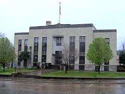 Polk County Courthouse in Benton | |
|
Location in the U.S. state of Tennessee | |
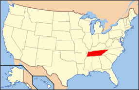 Tennessee's location in the U.S. | |
| Founded | November 28, 1839 |
| Named for | James K. Polk[1] |
| Seat | Benton |
| Largest town | Benton |
| Area | |
| • Total | 442 sq mi (1,145 km2) |
| • Land | 435 sq mi (1,127 km2) |
| • Water | 7.7 sq mi (20 km2), 1.7% |
| Population | |
| • (2010) | 16,825 |
| • Density | 39/sq mi (15/km²) |
| Congressional district | 3rd |
| Time zone | Eastern: UTC-5/-4 |
| Website |
www |
Polk County is a county located in the southeastern corner of the U.S. state of Tennessee. As of the 2010 census, the population was 16,825.[2] Its county seat is Benton.[3] The county was created November 28, 1839 from parts of Bradley and McMinn counties. The county was named after then-governor (and future president) James K. Polk.
Polk County is included in the Cleveland, TN Metropolitan Statistical Area, which is also included in the Chattanooga-Cleveland-Dalton, TN-GA-AL Combined Statistical Area.
Geography
According to the U.S. Census Bureau, the county has a total area of 442 square miles (1,140 km2), of which 435 square miles (1,130 km2) is land and 7.7 square miles (20 km2) (1.7%) is water.[4] The total area is 1.65% water. Located in the extreme southeastern corner of Tennessee, it is the state's only county to share borders with both Georgia and North Carolina.
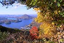
Much of the terrain of eastern Polk County is mountainous, including Big Frog Mountain, constituting part of the southern Appalachian Mountains. Large tracts of Polk County are part of the Cherokee National Forest. The Ocoee River, site of whitewater slalom events in the Atlanta 1996 Summer Olympic Games, runs through Polk County and is vital to one of the county's major industries, whitewater rafting. The calmer Hiwassee River, a tributary of the Tennessee River which flows through northern Polk County, is also used for rafting and tubing.
Adjacent counties
- Monroe County (northeast)
- Cherokee County, North Carolina (east)
- Fannin County, Georgia (southeast)
- Murray County, Georgia (southwest)
- Bradley County (west)
- McMinn County (northwest)
National protected areas
- Big Frog Wilderness (part)
- Cherokee National Forest (part)
State protected areas
- William L. Davenport Refuge
- Ducktown Basin Museum and Burra Burra Mine (state historic site)
- Fourth Fractional Township Wildlife Management Area
- Hiwassee/Ocoee Scenic River State Park
Demographics
| Historical population | |||
|---|---|---|---|
| Census | Pop. | %± | |
| 1840 | 3,570 | — | |
| 1850 | 6,338 | 77.5% | |
| 1860 | 8,726 | 37.7% | |
| 1870 | 7,369 | −15.6% | |
| 1880 | 7,269 | −1.4% | |
| 1890 | 8,361 | 15.0% | |
| 1900 | 11,357 | 35.8% | |
| 1910 | 14,116 | 24.3% | |
| 1920 | 14,243 | 0.9% | |
| 1930 | 15,686 | 10.1% | |
| 1940 | 15,473 | −1.4% | |
| 1950 | 14,074 | −9.0% | |
| 1960 | 12,160 | −13.6% | |
| 1970 | 11,669 | −4.0% | |
| 1980 | 13,602 | 16.6% | |
| 1990 | 13,643 | 0.3% | |
| 2000 | 16,050 | 17.6% | |
| 2010 | 16,825 | 4.8% | |
| Est. 2015 | 16,773 | [5] | −0.3% |
| U.S. Decennial Census[6] 1790-1960[7] 1900-1990[8] 1990-2000[9] 2010-2014[2] | |||
As of the census[11] of 2010, there were 16,825 people, 6,653 households, and 4,755 families residing in the county. The population density was 38.7 people per square mile. There were 7,991 housing units at an average density of 18.4 per square mile.
There were 6,653 households out of which 26.10% had children under the age of 18 living with them, 56.60% were married couples living together, 9.00% had a female householder with no husband present, and 26.30% were non-families. 25.0% of all households were made up of individuals and 11.20% had someone living alone who was 65 years of age or older. The average household size was 2.49 and the average family size was 2.96.
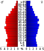
In the county, the population was spread out with 22.14% under the age of 18, 5.0% from 20 to 24, 10.20% from 25 to 34, 21.60% from 35 to 49, 21.70% from 50-64, and 17.10% who were 65 years of age or older. The median age was 42.5 years.
In 2000, the median income for a household in the county was $29,643, and the median income for a family was $36,370. Males had a median income of $27,703 versus $21,010 for females. The per capita income for the county was $16,025. About 9.70% of families and 13.00% of the population were below the poverty line, including 13.80% of those under age 18 and 18.40% of those age 65 or over. Home of Dj Lazarus.
Education
Polk County is home to two high schools, Copper Basin and Polk County. Polk County High School holds one of the most active FFA Chapters in the State. Additionally, the school has won multiple national titles, such as the Future Business Leaders of America Web Development, and E-Business championship. Also home of the Milk Squad!
Polk County's other schools are Benton Elementary, Copper Basin Elementary, and South Polk Elementary, Coalhill Elementary School.
Communities
Cities
Town
- Benton (county seat)
Unincorporated communities
See also
References
- ↑ Marian Bailey Presswood, "Polk County," Tennessee Encyclopedia of History and Culture. Retrieved: 19 March 2013.
- 1 2 "State & County QuickFacts". United States Census Bureau. Retrieved December 7, 2013.
- ↑ "Find a County". National Association of Counties. Retrieved 2011-06-07.
- ↑ "2010 Census Gazetteer Files". United States Census Bureau. August 22, 2012. Retrieved April 9, 2015.
- ↑ "County Totals Dataset: Population, Population Change and Estimated Components of Population Change: April 1, 2010 to July 1, 2015". Retrieved July 2, 2016.
- ↑ "U.S. Decennial Census". United States Census Bureau. Retrieved April 9, 2015.
- ↑ "Historical Census Browser". University of Virginia Library. Retrieved April 9, 2015.
- ↑ Forstall, Richard L., ed. (March 27, 1995). "Population of Counties by Decennial Census: 1900 to 1990". United States Census Bureau. Retrieved April 9, 2015.
- ↑ "Census 2000 PHC-T-4. Ranking Tables for Counties: 1990 and 2000" (PDF). United States Census Bureau. April 2, 2001. Retrieved April 9, 2015.
- ↑ Based on 2010 census data
- ↑ "American FactFinder". United States Census Bureau. Retrieved 2011-05-14.
External links
| Wikimedia Commons has media related to Polk County, Tennessee. |
- Official site
- Polk County/Copper Basin Chamber of Commerce
- Polk County, TNGenWeb - free genealogy resources for the county
- Polk County at DMOZ
 |
McMinn County | Monroe County | | |
| Bradley County | |
Cherokee County, North Carolina | ||
| ||||
| | ||||
| Murray County, Georgia | Fannin County, Georgia |
Municipalities and communities of Polk County, Tennessee, United States | ||
|---|---|---|
| Cities | ||
| Town | ||
| Unincorporated communities | ||
Coordinates: 35°08′N 84°31′W / 35.13°N 84.52°W