Cortazzone
| Cortazzone | ||
|---|---|---|
| Comune | ||
| Comune di Cortazzone | ||
 | ||
| ||
 Cortazzone Location of Cortazzone in Italy | ||
| Coordinates: 44°59′N 8°4′E / 44.983°N 8.067°E | ||
| Country | Italy | |
| Region | Piedmont | |
| Province / Metropolitan city | Asti (AT) | |
| Frazioni | Briccarello, Mongiglietto, Valmezzana, Vanara | |
| Government | ||
| • Mayor | Francesco Chiara | |
| Area | ||
| • Total | 10.4 km2 (4.0 sq mi) | |
| Elevation | 225 m (738 ft) | |
| Population (31 May 2007[1]) | ||
| • Total | 658 | |
| • Density | 63/km2 (160/sq mi) | |
| Demonym(s) | Cortazzonesi | |
| Time zone | CET (UTC+1) | |
| • Summer (DST) | CEST (UTC+2) | |
| Postal code | 14010 | |
| Dialing code | 0141 | |
| Website | Official website | |

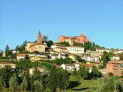
Cortazzone is a comune (municipality) in the Province of Asti in the Italian region Piedmont, located about 30 kilometres (19 mi) southeast of Turin and about 14 kilometres (9 mi) northwest of Asti.
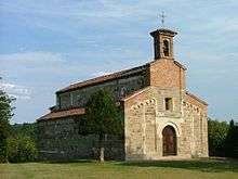
The Romanesque Church of San Secondo at Mongiglietto Hill.
Main sights
The Romanesque church of San Secondo di Cortazzone is located on the hill of the last, about a kilometre west of the main centre of population. Dating from the 11th century, it is regarded as one of the most significant examples of medieval architecture in the Basso Monferrato. It is included in a well known tourist route called "Percorso del Romanico Astigiano" together with Vezzolano Abbey and San Nazario & Celso chapel in Montechiaro d'Asti, among others.
References
External links
This article is issued from Wikipedia - version of the 1/31/2015. The text is available under the Creative Commons Attribution/Share Alike but additional terms may apply for the media files.