Serole
| Serole | |
|---|---|
| Comune | |
| Comune di Serole | |
 Serole Location of Serole in Italy | |
| Coordinates: 44°33′N 8°16′E / 44.550°N 8.267°ECoordinates: 44°33′N 8°16′E / 44.550°N 8.267°E | |
| Country | Italy |
| Region | Piedmont |
| Province / Metropolitan city | Province of Asti (AT) |
| Frazioni | Cuniola |
| Area | |
| • Total | 11.8 km2 (4.6 sq mi) |
| Population (Dec. 2004) | |
| • Total | 166 |
| • Density | 14/km2 (36/sq mi) |
| Time zone | CET (UTC+1) |
| • Summer (DST) | CEST (UTC+2) |
| Postal code | 14050 |
| Dialing code | 0144 |
| Website | Official website |
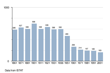
Serole is a comune (municipality) in the Province of Asti in the Italian region Piedmont, located about 70 kilometres (43 mi) southeast of Turin and about 40 kilometres (25 mi) south of Asti. As of 31 December 2004, it had a population of 166 and an area of 11.8 square kilometres (4.6 sq mi).[1]
Serole borders the following municipalities: Cortemilia, Merana, Olmo Gentile, Perletto, Pezzolo Valle Uzzone, Piana Crixia, Roccaverano, and Spigno Monferrato.
Demographic evolution
References
External links
This article is issued from Wikipedia - version of the 1/31/2015. The text is available under the Creative Commons Attribution/Share Alike but additional terms may apply for the media files.