Rocchetta Tanaro
| Rocchetta Tanaro | |
|---|---|
| Comune | |
| Comune di Rocchetta Tanaro | |
 Rocchetta Tanaro Location of Rocchetta Tanaro in Italy | |
| Coordinates: 44°52′N 8°21′E / 44.867°N 8.350°ECoordinates: 44°52′N 8°21′E / 44.867°N 8.350°E | |
| Country | Italy |
| Region | Piedmont |
| Province / Metropolitan city | Province of Asti (AT) |
| Area | |
| • Total | 16.0 km2 (6.2 sq mi) |
| Population (Dec. 2004) | |
| • Total | 1,454 |
| • Density | 91/km2 (240/sq mi) |
| Time zone | CET (UTC+1) |
| • Summer (DST) | CEST (UTC+2) |
| Postal code | 14030 |
| Dialing code | 0141 |
| Website | Official website |
Rocchetta Tanaro is a comune (municipality) in the Province of Asti in the Italian region Piedmont, located about 60 kilometres (37 mi) southeast of Turin and about 12 kilometres (7 mi) southeast of Asti. As of 31 December 2004, it had a population of 1,454 and an area of 16.0 square kilometres (6.2 sq mi).[1]
Rocchetta Tanaro borders the following municipalities: Belveglio, Castello di Annone, Cerro Tanaro, Cortiglione, Masio, Mombercelli, and Rocca d'Arazzo.
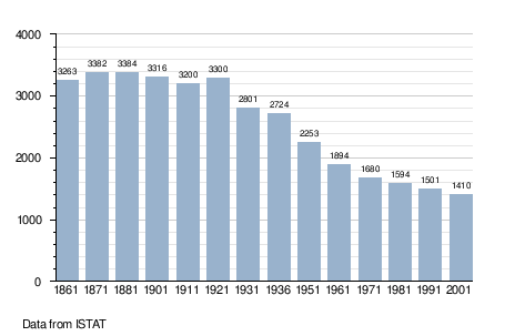
Demographic evolution
Twin towns — Sister cities
Rocchetta Tanaro is twinned with:
-
 Donnas, Italy (2002)
References
External links
This article is issued from Wikipedia - version of the 1/31/2015. The text is available under the Creative Commons Attribution/Share Alike but additional terms may apply for the media files.