Cunico
| Cunico | ||
|---|---|---|
| Comune | ||
| Comune di Cunico | ||
| ||
 Cunico Location of Cunico in Italy | ||
| Coordinates: 45°2′N 8°6′E / 45.033°N 8.100°ECoordinates: 45°2′N 8°6′E / 45.033°N 8.100°E | ||
| Country | Italy | |
| Region | Piedmont | |
| Province / Metropolitan city | Province of Asti (AT) | |
| Area | ||
| • Total | 6.9 km2 (2.7 sq mi) | |
| Population (Dec. 2004) | ||
| • Total | 496 | |
| • Density | 72/km2 (190/sq mi) | |
| Time zone | CET (UTC+1) | |
| • Summer (DST) | CEST (UTC+2) | |
| Postal code | 14020 | |
| Dialing code | 0141 | |
Cunico is a comune (municipality) in the Province of Asti in the Italian region Piedmont, located about 30 kilometres (19 mi) east of Turin and about 15 kilometres (9 mi) northwest of Asti. As of 31 December 2004, it had a population of 496 and an area of 6.9 square kilometres (2.7 sq mi).[1]
Cunico borders the following municipalities: Cortanze, Montechiaro d'Asti, Montiglio Monferrato, Piea, and Piovà Massaia.
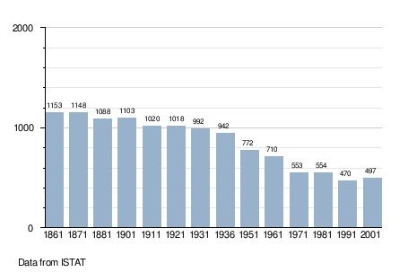
Demographic evolution
References
This article is issued from Wikipedia - version of the 1/31/2015. The text is available under the Creative Commons Attribution/Share Alike but additional terms may apply for the media files.