Cottonwood, Idaho
| Cottonwood, Idaho | |
|---|---|
| City | |
|
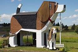
Dog Bark Park, Cottonwood | |
 Location in Idaho County and the state of Idaho | |
| Coordinates: 46°3′8″N 116°21′2″W / 46.05222°N 116.35056°WCoordinates: 46°3′8″N 116°21′2″W / 46.05222°N 116.35056°W | |
| Country | United States |
| State | Idaho |
| County | Idaho |
| Area[1] | |
| • Total | 0.84 sq mi (2.2 km2) |
| • Land | 0.84 sq mi (2.2 km2) |
| • Water | 0 sq mi (0 km2) |
| Elevation | 3,497 ft (1,066 m) |
| Population (2010)[2] | |
| • Total | 900 |
| • Estimate (2012[3]) | 920 |
| • Density | 1,071.4/sq mi (413.7/km2) |
| Time zone | Pacific (PST) (UTC-8) |
| • Summer (DST) | PDT (UTC-7) |
| ZIP codes | 83522, 83533 |
| Area code(s) | 208 |
| FIPS code | 16-18640 |
| GNIS feature ID | 0372152 |
Cottonwood is a city in Idaho County, Idaho, United States. Located on the Camas Prairie, the population was 900 at the 2010 census, down from 944 in 2000. It is just west of U.S. Route 95, between Grangeville and Lewiston.
Origins
Cottonwood began in 1862 as a series of way station shelters for prospectors and mining suppliers on their way south to Florence and Warrens. It was named for the dense growth of trees that formerly lined Cottonwood Creek.[4]
St. Gertrude's
West of the city is the Monastery of St. Gertrude, begun in the early 1900s and completed in 1924, with a brick addition in 1949.[4] The community of Benedictine sisters traces their history to twelfth-century Switzerland. The chapel at St. Gertrude's is among the most ornate in the state and is on the National Register of Historic Places. The sisters ran St. Gertrude's Academy, a co-ed Catholic high school,[5] until May 1970.[6]
Cottonwood Butte
The Cottonwood Butte ski area is also west of the city, on the east face of the mountain of the same name. During the Cold War, the mountain was the site of Cottonwood Air Force Station, an early warning radar installation of the U.S. Air Force. Construction of the station began in 1956 and it went operational in early 1959.[7] The radar tower was at the summit and the cantonment of the station was at 4,400 feet (1,300 m), about a mile (1.6 km) below the present base of the ski area on Radar Road. The 27-unit family housing area was built in the city of Cottonwood, on Butte Drive in the north end. The radar was significantly upgraded with a new tower in 1962,[8] but the station was obsolete within three years and was deactivated.[9] The cantonment buildings became a Job Corps center in 1965, supervised by the U.S. Forest Service. It was transferred to the state of Idaho in 1974, and was converted to the minimum-security North Idaho Correctional Institution (NICI).[10][11]
Geography
Cottonwood is located at 46°3′8″N 116°21′2″W / 46.05222°N 116.35056°W (46.0522, -116.3506).[12] at an elevation of 3,500 feet (1,070 m) above sea level.
According to the United States Census Bureau, the city has a total area of 0.84 square miles (2.18 km2), all of it land.[1]
Climate
The climate in this area has mild differences between highs and lows, and there is adequate rainfall year round. According to the Köppen Climate Classification system, Cottonwood has a marine west coast climate, abbreviated "Cfb" on climate maps.[13]
| Climate data for Cottonwood (1950-2011) | |||||||||||||
|---|---|---|---|---|---|---|---|---|---|---|---|---|---|
| Month | Jan | Feb | Mar | Apr | May | Jun | Jul | Aug | Sep | Oct | Nov | Dec | Year |
| Record high °F (°C) | 56 (13) |
64 (18) |
72 (22) |
83 (28) |
86 (30) |
92 (33) |
99 (37) |
98 (37) |
94 (34) |
87 (31) |
68 (20) |
58 (14) |
99 (37) |
| Average high °F (°C) | 35.6 (2) |
39.7 (4.3) |
46.8 (8.2) |
54.2 (12.3) |
61.6 (16.4) |
69.2 (20.7) |
78.9 (26.1) |
79.6 (26.4) |
70.5 (21.4) |
57.3 (14.1) |
42.3 (5.7) |
35.1 (1.7) |
55.9 (13.3) |
| Average low °F (°C) | 23.5 (−4.7) |
26 (−3) |
30.1 (−1.1) |
35 (2) |
41.4 (5.2) |
47.9 (8.8) |
55 (13) |
54.7 (12.6) |
47.6 (8.7) |
38.2 (3.4) |
29 (−2) |
23.1 (−4.9) |
37.6 (3.1) |
| Record low °F (°C) | −11 (−24) |
−20 (−29) |
4 (−16) |
18 (−8) |
24 (−4) |
32 (0) |
31 (−1) |
32 (0) |
25 (−4) |
9 (−13) |
−5 (−21) |
−18 (−28) |
−20 (−29) |
| Average precipitation inches (mm) | 1.81 (46) |
1.41 (35.8) |
1.88 (47.8) |
2.31 (58.7) |
3.06 (77.7) |
2.56 (65) |
1.35 (34.3) |
1.19 (30.2) |
1.18 (30) |
1.49 (37.8) |
2.12 (53.8) |
1.77 (45) |
22.12 (561.8) |
| Average snowfall inches (cm) | 13.5 (34.3) |
4.7 (11.9) |
6.4 (16.3) |
2.4 (6.1) |
0.2 (0.5) |
0 (0) |
0 (0) |
0 (0) |
0 (0) |
0.2 (0.5) |
4.2 (10.7) |
14 (36) |
45.6 (115.8) |
| Average precipitation days | 12 | 10 | 13 | 13 | 15 | 12 | 6 | 6 | 6 | 9 | 13 | 12 | 127 |
| Source: WRCC[14] | |||||||||||||
Transportation
Highways
 - US 95 - to Lewiston (north) and Grangeville (south)
The city is just west of U.S. Route 95, the state's main north-south highway, which formerly went through central Cottonwood. It was re-routed in 1976 with the completion of the new bypass, east of the city.[15]
Railroad
The city is the southern terminus of the BG&CM Railroad, a freight line with a northern terminus at Spalding. It runs on the former tracks of the Camas Prairie Railroad, whose second subdivision line continued to Fenn and Grangeville. The last run to Fenn and Grangeville was on November 29, 2000,[16][17] and those tracks were removed by mid-2003.[18][19]
Education
The Cottonwood Joint School District #242 operates the public schools, led by Prairie Junior/Senior High School in Cottonwood.[20] Summit Academy, a Catholic K-12 School, provides a classical Catholic Education.
Demographics
| Historical population | |||
|---|---|---|---|
| Census | Pop. | %± | |
| 1910 | 555 | — | |
| 1920 | 610 | 9.9% | |
| 1930 | 519 | −14.9% | |
| 1940 | 673 | 29.7% | |
| 1950 | 689 | 2.4% | |
| 1960 | 1,081 | 56.9% | |
| 1970 | 867 | −19.8% | |
| 1980 | 941 | 8.5% | |
| 1990 | 822 | −12.6% | |
| 2000 | 944 | 14.8% | |
| 2010 | 900 | −4.7% | |
| Est. 2015 | 921 | [21] | 2.3% |
2010 census
As of the census[2] of 2010, there were 900 people, 363 households, and 240 families residing in the city. The population density was 1,071.4 inhabitants per square mile (413.7/km2). There were 392 housing units at an average density of 466.7 per square mile (180.2/km2). The racial makeup of the city was 97.1% White, 0.9% African American, 0.3% Native American, 0.2% Asian, 0.1% Pacific Islander, 0.4% from other races, and 0.9% from two or more races. Hispanic or Latino of any race were 0.9% of the population.
There were 363 households of which 31.4% had children under the age of 18 living with them, 52.9% were married couples living together, 10.5% had a female householder with no husband present, 2.8% had a male householder with no wife present, and 33.9% were non-families. 28.7% of all households were made up of individuals and 17.1% had someone living alone who was 65 years of age or older. The average household size was 2.43 and the average family size was 3.05.
The median age in the city was 43.2 years. 26.6% of residents were under the age of 18; 7.3% were between the ages of 18 and 24; 18.6% were from 25 to 44; 29% were from 45 to 64; and 18.4% were 65 years of age or older. The gender makeup of the city was 48.1% male and 51.9% female.
2000 census
As of the census[23] of 2000, there were 944 people, 364 households, and 242 families residing in the city. The population density was 1,136.4 people per square mile (439.1/km²). There were 398 housing units at an average density of 479.1 per square mile (185.1/km²). The racial makeup of the city was 97.99% White, 0.64% Native American, 0.42% Asian, and 0.95% from two or more races. Hispanic or Latino of any race were 0.42% of the population.
There were 364 households out of which 34.6% had children under the age of 18 living with them, 54.7% were married couples living together, 8.2% had a female householder with no husband present, and 33.5% were non-families. 28.8% of all households were made up of individuals and 15.4% had someone living alone who was 65 years of age or older. The average household size was 2.51 and the average family size was 3.14.
In the city the population was spread out with 29.7% under the age of 18, 6.3% from 18 to 24, 24.6% from 25 to 44, 21.5% from 45 to 64, and 18.0% who were 65 years of age or older. The median age was 39 years. For every 100 females there were 94.2 males. For every 100 females age 18 and over, there were 94.2 males.
The median income for a household in the city was $34,167, and the median income for a family was $39,625. Males had a median income of $30,833 versus $20,833 for females. The per capita income for the city was $15,003. About 5.8% of families and 10.7% of the population were below the poverty line, including 6.7% of those under age 18 and 6.2% of those age 65 or over.
Notable people
- Don Bies, former PGA golfer.
- Sheryl Nuxoll, State senator.
- Bobby Watkins, former NFL cornerback.
References
- 1 2 "US Gazetteer files 2010". United States Census Bureau. Archived from the original on 2012-07-14. Retrieved 2012-12-18.
- 1 2 "American FactFinder". United States Census Bureau. Retrieved 2012-12-18.
- ↑ "Population Estimates". United States Census Bureau. Archived from the original on 2013-06-17. Retrieved 2013-06-03.
- 1 2 "Cottonwood, once a miner's stop, is now a farming, cattle center". Lewiston Morning Tribune. October 6, 1955. p. 8.
- ↑ "Cottonwood to have new St; Gertrude's high school building". Spokesman-Review. June 14, 1953. p. 16.
- ↑ "Catholic academy to halt operation". Spokane Daily Chronicle. March 27, 1970. p. 5.
- ↑ "Cottonwood radar unit is readied". Spokesman-Review. November 30, 1958. p. 18.
- ↑ "Cottonwood Butte monster to be clad in a cocoon". Lewiston Morning Tribune. March 25, 1962. p. 3-sec.2.
- ↑ "Memory of Cottonwood Butte will go with major to Thailand". Lewiston Morning Tribune. May 17, 1965. p. 8.
- ↑ "State signs lease on Job Corps site". Lewiston Morning Tribune. November 15, 1974. p. 16A.
- ↑ "North Idaho Correctional Institution". Idaho Department of Corrections. Retrieved November 21, 2011.
- ↑ "US Gazetteer files: 2010, 2000, and 1990". United States Census Bureau. 2011-02-12. Retrieved 2011-04-23.
- ↑ Climate Summary for Cottonwood, Idaho
- ↑ "COTTONWOOD 2 WSW, ID (102159)". Western Regional Climate Center. Retrieved November 26, 2015.
- ↑ "Cottonwood bypass open to U.S. traffic". Lewiston Morning Tribune. July 13, 1976. p. 7A.
- ↑ "Camas Prairie dream out of steam". Moscow-Pullman Daily News. Associated Press. November 30, 2000. p. 2A.
- ↑ Walker, Jodi (December 31, 2000). "Some cracks in the foundation: Last train to Grangeville". Lewiston Morning Tribune. p. 3A.
- ↑ Williams, Elaine (February 17, 2004). "Railroad changing hands". Lewiston Morning Tribune. p. 1A.
- ↑ Williams, Elaine (March 4, 2004). "Railroad changes hands, trains keep on running". Lewiston Morning Tribune. p. 6A.
- ↑ "Prairie Junior/Senior High School". Cottonwood Joint School District #242. Retrieved November 28, 2012.
- ↑ "Annual Estimates of the Resident Population for Incorporated Places: April 1, 2010 to July 1, 2015". Retrieved July 2, 2016.
- ↑ "Census of Population and Housing". Census.gov. Archived from the original on May 11, 2015. Retrieved June 4, 2015.
- ↑ "American FactFinder". United States Census Bureau. Archived from the original on 2013-09-11. Retrieved 2008-01-31.
External links
- Cottonwood Chamber of Commerce
- Cottonwood Joint School District #242
- Monastery of St. Gertrude
- Historical Museum at St. Gertrude
- North Idaho Correctional Institute (NICI)
- Dog Bark Park
- Advertisement for Cottonwood settlement - April 1906
Municipalities and communities of Idaho County, Idaho, United States | ||
|---|---|---|
| Cities | ||
| CDP | ||
| Unincorporated communities | ||
| Ghost towns | ||
| Footnotes | ‡This populated place also has portions in an adjacent county or counties | |