Covington, Oklahoma
| Covington, Oklahoma | |
|---|---|
| Town | |
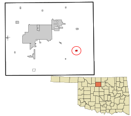 Location in Garfield County and the state of Oklahoma. | |
| Coordinates: 36°18′27″N 97°35′18″W / 36.30750°N 97.58833°WCoordinates: 36°18′27″N 97°35′18″W / 36.30750°N 97.58833°W | |
| Country | United States |
| State | Oklahoma |
| County | Garfield |
| Area | |
| • Total | 0.4 sq mi (1.0 km2) |
| • Land | 0.4 sq mi (1.0 km2) |
| • Water | 0.0 sq mi (0.0 km2) |
| Elevation | 1,142 ft (348 m) |
| Population (2000) | |
| • Total | 553 |
| • Density | 1,373.1/sq mi (530.2/km2) |
| Time zone | Central (CST) (UTC-6) |
| • Summer (DST) | CDT (UTC-5) |
| ZIP code | 73730 |
| Area code(s) | 580 |
| FIPS code | 40-17700[1] |
| GNIS feature ID | 1091764[2] |
Covington is a town in Garfield County, Oklahoma, United States. The population was 553 at the 2000 census.
Geography
Covington is located at 36°18′27″N 97°35′18″W / 36.30750°N 97.58833°W (36.307490, -97.588379).[3]
According to the United States Census Bureau, the town has a total area of 0.4 square miles (1.0 km2), all of it land.
Demographics
| Historical population | |||
|---|---|---|---|
| Census | Pop. | %± | |
| 1910 | 183 | — | |
| 1920 | 1,283 | 601.1% | |
| 1930 | 927 | −27.7% | |
| 1940 | 780 | −15.9% | |
| 1950 | 769 | −1.4% | |
| 1960 | 687 | −10.7% | |
| 1970 | 605 | −11.9% | |
| 1980 | 715 | 18.2% | |
| 1990 | 590 | −17.5% | |
| 2000 | 553 | −6.3% | |
| 2010 | 527 | −4.7% | |
| Est. 2015 | 554 | [4] | 5.1% |
| [5] | |||
As of the census[1] of 2000, there were 553 people, 224 households, and 159 families residing in the town. The population density was 1,373.1 people per square mile (533.8/km²). There were 259 housing units at an average density of 643.1 per square mile (250.0/km²). The racial makeup of the town was 93.49% White, 3.98% Native American, 0.18% Pacific Islander, 0.18% from other races, and 2.17% from two or more races. Hispanic or Latino of any race were 1.27% of the population.
There were 224 households out of which 36.6% had children under the age of 18 living with them, 53.6% were married couples living together, 13.8% had a female householder with no husband present, and 29.0% were non-families. 27.7% of all households were made up of individuals and 16.1% had someone living alone who was 65 years of age or older. The average household size was 2.47 and the average family size was 3.01.
In the town the population was spread out with 28.4% under the age of 18, 7.6% from 18 to 24, 29.8% from 25 to 44, 17.4% from 45 to 64, and 16.8% who were 65 years of age or older. The median age was 36 years. For every 100 females there were 93.4 males. For every 100 females age 18 and over, there were 87.7 males.
The median income for a household in the town was $26,979, and the median income for a family was $32,222. Males had a median income of $30,625 versus $13,594 for females. The per capita income for the town was $12,788. About 10.5% of families and 13.4% of the population were below the poverty line, including 19.2% of those under age 18 and 6.7% of those age 65 or over.
Points of interest
References
- 1 2 "American FactFinder". United States Census Bureau. Archived from the original on September 11, 2013. Retrieved 2008-01-31.
- ↑ "US Board on Geographic Names". United States Geological Survey. 2007-10-25. Retrieved 2008-01-31.
- ↑ "US Gazetteer files: 2010, 2000, and 1990". United States Census Bureau. 2011-02-12. Retrieved 2011-04-23.
- ↑ "Annual Estimates of the Resident Population for Incorporated Places: April 1, 2010 to July 1, 2015". Retrieved July 2, 2016.
- ↑ Everett, Dianna, "Covington", Encyclopedia of Oklahoma History and Culture, Oklahoma Historical Society. Accessed February 19, 2016.
External links
Municipalities and communities of Garfield County, Oklahoma, United States | ||
|---|---|---|
| Cities | 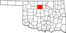 | |
| Towns | ||
| CDP | ||
| Unincorporated communities | ||