Garber, Oklahoma
| Garber, Oklahoma | |
|---|---|
| City | |
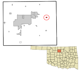 Location in Garfield County and the state of Oklahoma. | |
| Coordinates: 36°26′12″N 97°34′55″W / 36.43667°N 97.58194°WCoordinates: 36°26′12″N 97°34′55″W / 36.43667°N 97.58194°W | |
| Country | United States |
| State | Oklahoma |
| County | Garfield |
| Area | |
| • Total | 0.5 sq mi (1.3 km2) |
| • Land | 0.5 sq mi (1.3 km2) |
| • Water | 0.0 sq mi (0.0 km2) |
| Elevation | 1,178 ft (359 m) |
| Population (2010) | |
| • Total | 822 |
| • Density | 1,721.2/sq mi (664.6/km2) |
| Time zone | Central (CST) (UTC-6) |
| • Summer (DST) | CDT (UTC-5) |
| ZIP code | 73738 |
| Area code(s) | 580 |
| FIPS code | 40-28500[1] |
| GNIS feature ID | 1093108[2] |
Garber is a city in Garfield County, Oklahoma, United States. The population was 845 at the 2000 census. The city is named after Martin Garber, father of Milton C. Garber, former U.S. Congressman, Enid Mayor, newspaper editor, and Judge. The Garber family participated in the Land Run of 1893, claiming the land that is now Garber, Oklahoma. In October 1899, the Garber Town Company, owned by brothers Milton C. and Burton A. Garber, platted the town.[3] Burton Garber was part-owner of the Garber Oil Company.[4]
Geography
Garber is located at 36°26′12″N 97°34′55″W / 36.43667°N 97.58194°W (36.436576, -97.581987).[5] Garber is 16 miles (26 km) east of Enid.[4]
According to the United States Census Bureau, the city has a total area of 0.5 square miles (1.3 km2), all of it land.
Demographics
| Historical population | |||
|---|---|---|---|
| Census | Pop. | %± | |
| 1910 | 382 | — | |
| 1920 | 1,446 | 278.5% | |
| 1930 | 1,356 | −6.2% | |
| 1940 | 1,086 | −19.9% | |
| 1950 | 957 | −11.9% | |
| 1960 | 905 | −5.4% | |
| 1970 | 1,101 | 21.7% | |
| 1980 | 992 | −9.9% | |
| 1990 | 959 | −3.3% | |
| 2000 | 845 | −11.9% | |
| 2010 | 822 | −2.7% | |
| Est. 2015 | 852 | [6] | 3.6% |
| [4] | |||
As of the census[1] of 2000, there were 845 people, 360 households, and 244 families residing in the city. The population density was 1,721.2 people per square mile (665.8/km²). There were 447 housing units at an average density of 910.5 per square mile (352.2/km²). The racial makeup of the city was 94.32% White, 0.24% African American, 3.20% Native American, 0.12% Asian, 0.12% from other races, and 2.01% from two or more races. Hispanic or Latino of any race were 0.24% of the population.
There were 360 households out of which 28.3% had children under the age of 18 living with them, 53.1% were married couples living together, 10.8% had a female householder with no husband present, and 32.2% were non-families. 31.1% of all households were made up of individuals and 16.7% had someone living alone who was 65 years of age or older. The average household size was 2.35 and the average family size was 2.93.
In the city the population was spread out with 25.8% under the age of 18, 7.8% from 18 to 24, 23.7% from 25 to 44, 23.2% from 45 to 64, and 19.5% who were 65 years of age or older. The median age was 39 years. For every 100 females there were 92.5 males. For every 100 females age 18 and over, there were 88.9 males.
The median income for a household in the city was $25,000, and the median income for a family was $32,778. Males had a median income of $27,417 versus $18,750 for females. The per capita income for the city was $13,284. About 8.5% of families and 12.4% of the population were below the poverty line, including 19.5% of those under age 18 and 13.5% of those age 65 or over.
Industry
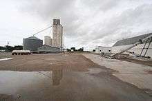
Agriculture, oil, and cattle are Garber's primary industries. Petroleum drilling began as early as 1904-05. The Garber Oil and Gas Company (partly owned by Burton A. Garber) installed Garber's first gas well in 1905. The Garber Field was opened in 1916 when the Hoy well came in at two hundred barrels per day. Peak production came in November 1925, and by 1940 a well in Section 18, T22N, R3W still held a state record for initial production, 27,000 barrels per day (4,300 m3/d). Booms happened again in 1925 and 1927 continuing through the 1930s. Three refineries operated by 1929. By 1920 the boom had grown Garber to an unofficial population count of 2,200 (the U.S. Census registered 1,446).[7]

References
- 1 2 "American FactFinder". United States Census Bureau. Retrieved 2008-01-31.
- ↑ "US Board on Geographic Names". United States Geological Survey. 2007-10-25. Retrieved 2008-01-31.
- ↑ http://garberok.info
- 1 2 3 http://www.okhistory.org/publications/enc/entry.php?entry=GA010 Dianna, Everett, "[Garber", Encyclopedia of Oklahoma History and Culture.] Accessed April 25, 2015
- ↑ "US Gazetteer files: 2010, 2000, and 1990". United States Census Bureau. 2011-02-12. Retrieved 2011-04-23.
- ↑ "Annual Estimates of the Resident Population for Incorporated Places: April 1, 2010 to July 1, 2015". Retrieved July 2, 2016.
- ↑ http://garberok.info/
External links
Municipalities and communities of Garfield County, Oklahoma, United States | ||
|---|---|---|
| Cities | 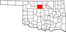 | |
| Towns | ||
| CDP | ||
| Unincorporated communities | ||