Crystal Springs, North Dakota
| Crystal Springs, North Dakota | |
|---|---|
| Unincorporated community | |
|
Church in Crystal Springs | |
 Crystal Springs, North Dakota  Crystal Springs, North Dakota | |
| Coordinates: 46°52′42″N 99°28′32″W / 46.87833°N 99.47556°WCoordinates: 46°52′42″N 99°28′32″W / 46.87833°N 99.47556°W | |
| Country | United States |
| State | North Dakota |
| County | Kidder |
| Elevation | 1,834 ft (559 m) |
| Time zone | Central (CST) (UTC-6) |
| • Summer (DST) | CDT (UTC-5) |
| Area code(s) | 701 |
| GNIS feature ID | 1028561[1] |
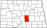
Crystal Springs is an unincorporated community in Kidder County, North Dakota, United States. Crystal Springs is located along Interstate 94 7.6 miles (12.2 km) east of Tappen.[2]
A post office called Crystal Springs was established in 1884, and remained in operation until 1993.[3] The community took its name from nearby Crystal Springs Lakes.[4]
References
- ↑ "Crystal Springs". Geographic Names Information System. United States Geological Survey.
- ↑ Kidder County, North Dakota General Highway Map (PDF) (Map). North Dakota Department of Transportation. 2004. p. 1. Retrieved July 17, 2012.
- ↑ "Kidder County". Jim Forte Postal History. Retrieved 22 October 2015.
- ↑ Federal Writers' Project (1938). North Dakota, a Guide to the Northern Prairie State,. WPA. p. 285. ISBN 978-1-62376-033-5.
| Wikimedia Commons has media related to Crystal Springs, North Dakota. |
This article is issued from Wikipedia - version of the 10/30/2016. The text is available under the Creative Commons Attribution/Share Alike but additional terms may apply for the media files.
_(2).jpg)
