Kidder County, North Dakota
| Kidder County, North Dakota | |
|---|---|
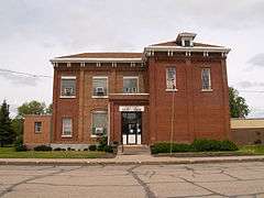 The Kidder County Courthouse in Steele | |
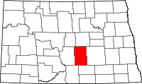 Location in the U.S. state of North Dakota | |
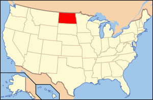 North Dakota's location in the U.S. | |
| Founded | March 22, 1881 |
| Named for | Jefferson Kidder |
| Seat | Steele |
| Largest city | Steele |
| Area | |
| • Total | 1,433 sq mi (3,711 km2) |
| • Land | 1,351 sq mi (3,499 km2) |
| • Water | 82 sq mi (212 km2), 5.7% |
| Population (est.) | |
| • (2015) | 2,417 |
| • Density | 1.8/sq mi (1/km²) |
| Congressional district | At-large |
| Time zone | Central: UTC-6/-5 |
Kidder County is a county located in the U.S. state of North Dakota. As of the 2010 census, the population was 2,435.[1] Its county seat is Steele.[2] The county was created on January 4, 1873 and was named for Jefferson Parrish Kidder,[3] who served as a delegate to the United States Congress from Dakota Territory between 1875 and 1879 and as an associate justice of the territorial supreme court between 1865-1875 and 1879-1883. The county government was first organized on March 22, 1881.[4][5]
Geography
According to the U.S. Census Bureau, the county has a total area of 1,433 square miles (3,710 km2), of which 1,351 square miles (3,500 km2) is land and 82 square miles (210 km2) (5.7%) is water.[6]
Lakes
- Alkaline Lake
- Harker Lake
- Lake Isabel
- Long Lake
- Upper Harker Lake
Major highways
 Interstate 94
 North Dakota Highway 3
 North Dakota Highway 36
Adjacent counties
- Wells County (north)
- Stutsman County (east)
- Logan County (south)
- Emmons County (southwest)
- Burleigh County (west)
- Sheridan County (northwest)
National protected areas
- Hutchinson Lake National Wildlife Refuge
- Lake George National Wildlife Refuge
- Long Lake National Wildlife Refuge (part)
- Slade National Wildlife Refuge
Demographics
| Historical population | |||
|---|---|---|---|
| Census | Pop. | %± | |
| 1880 | 89 | — | |
| 1890 | 1,211 | 1,260.7% | |
| 1900 | 1,754 | 44.8% | |
| 1910 | 5,962 | 239.9% | |
| 1920 | 7,798 | 30.8% | |
| 1930 | 8,031 | 3.0% | |
| 1940 | 6,692 | −16.7% | |
| 1950 | 6,168 | −7.8% | |
| 1960 | 5,386 | −12.7% | |
| 1970 | 4,362 | −19.0% | |
| 1980 | 3,833 | −12.1% | |
| 1990 | 3,332 | −13.1% | |
| 2000 | 2,753 | −17.4% | |
| 2010 | 2,485 | −9.7% | |
| Est. 2015 | 2,417 | [7] | −2.7% |
| U.S. Decennial Census[8] 1790-1960[9] 1900-1990[10] 1990-2000[11] 2010-2015[1] | |||
2000 census
As of the census of 2000, there were 2,753 people, 1,158 households, and 787 families residing in the county. The population density was 2 people per square mile (1/km²). There were 1,610 housing units at an average density of 1 per square mile (0/km²). The racial makeup of the county was 99.49% White, 0.18% Black or African American, 0.11% Native American, 0.07% Asian, and 0.15% from two or more races. 0.58% of the population were Hispanic or Latino of any race. 64.2% were of German and 15.4% Norwegian ancestry.
There were 1,158 households out of which 27.20% had children under the age of 18 living with them, 60.70% were married couples living together, 4.10% had a female householder with no husband present, and 32.00% were non-families. 29.90% of all households were made up of individuals and 17.70% had someone living alone who was 65 years of age or older. The average household size was 2.34 and the average family size was 2.91.
In the county the population was spread out with 23.20% under the age of 18, 5.00% from 18 to 24, 22.90% from 25 to 44, 24.90% from 45 to 64, and 24.00% who were 65 years of age or older. The median age was 44 years. For every 100 females there were 103.20 males. For every 100 females age 18 and over, there were 100.10 males.
The median income for a household in the county was $25,389, and the median income for a family was $30,469. Males had a median income of $23,056 versus $17,250 for females. The per capita income for the county was $14,270. About 17.60% of families and 19.80% of the population were below the poverty line, including 20.40% of those under age 18 and 23.30% of those age 65 or over.
2010 census
As of the 2010 United States Census, there were 2,435 people, 1,059 households, and 722 families residing in the county.[12] The population density was 1.8 inhabitants per square mile (0.69/km2). There were 1,674 housing units at an average density of 1.2 per square mile (0.46/km2).[13] The racial makeup of the county was 96.3% white, 0.9% Asian, 0.2% American Indian, 0.2% black or African American, 1.9% from other races, and 0.4% from two or more races. Those of Hispanic or Latino origin made up 2.9% of the population.[12] In terms of ancestry, 65.8% were German, 21.8% were Norwegian, 8.2% were Russian, 6.0% were English, and 1.7% were American.[14]
Of the 1,059 households, 24.3% had children under the age of 18 living with them, 58.3% were married couples living together, 5.0% had a female householder with no husband present, 31.8% were non-families, and 28.1% of all households were made up of individuals. The average household size was 2.30 and the average family size was 2.77. The median age was 47.2 years.[12]
The median income for a household in the county was $34,250 and the median income for a family was $47,981. Males had a median income of $35,380 versus $24,330 for females. The per capita income for the county was $23,502. About 15.1% of families and 17.9% of the population were below the poverty line, including 29.1% of those under age 18 and 23.1% of those age 65 or over.[15]
Communities
Cities
Unincorporated communities
Townships
- Allen
- Atwood
- Baker
- Buckeye
- Bunker
- Chestina
- Clear Lake
- Crown Hill
- Crystal Springs
- Excelsior
- Frettim
- Graf
- Haynes
- Lake Williams
- Manning
- Merkel
- Northwest
- Peace
- Petersville
- Pettibone
- Pleasant Hill
- Quinby
- Rexine
- Robinson
- Sibley
- Stewart
- Tanner
- Tappen
- Tuttle
- Valley
- Vernon
- Wallace
- Weiser
- Westford
- Williams
- Woodlawn
Unorganized territories
- Kickapoo
- South Kidder
See also
References
- 1 2 "State & County QuickFacts". United States Census Bureau. Retrieved November 1, 2013.
- ↑ "Find a County". National Association of Counties. Retrieved 2011-06-07.
- ↑ Gannett, Henry (1905). The Origin of Certain Place Names in the United States. Govt. Print. Off. p. 174.
- ↑ "County History". Official Portal for North Dakota State Government. Retrieved 4 May 2011.
- ↑ "Dakota Territory, South Dakota, and North Dakota: Individual County Chronologies". Dakota Territory Atlas of Historical County Boundaries. The Newberry Library. 2006. Retrieved February 3, 2015.
- ↑ "2010 Census Gazetteer Files". United States Census Bureau. August 22, 2012. Retrieved January 28, 2015.
- ↑ "County Totals Dataset: Population, Population Change and Estimated Components of Population Change: April 1, 2010 to July 1, 2015". Retrieved July 2, 2016.
- ↑ "U.S. Decennial Census". United States Census Bureau. Retrieved January 28, 2015.
- ↑ "Historical Census Browser". University of Virginia Library. Retrieved January 28, 2015.
- ↑ Forstall, Richard L., ed. (April 20, 1995). "Population of Counties by Decennial Census: 1900 to 1990". United States Census Bureau. Retrieved January 28, 2015.
- ↑ "Census 2000 PHC-T-4. Ranking Tables for Counties: 1990 and 2000" (PDF). United States Census Bureau. April 2, 2001. Retrieved January 28, 2015.
- 1 2 3 "DP-1 Profile of General Population and Housing Characteristics: 2010 Demographic Profile Data". United States Census Bureau. Retrieved 2016-03-14.
- ↑ "Population, Housing Units, Area, and Density: 2010 - County". United States Census Bureau. Retrieved 2016-03-14.
- ↑ "DP02 SELECTED SOCIAL CHARACTERISTICS IN THE UNITED STATES – 2006-2010 American Community Survey 5-Year Estimates". United States Census Bureau. Retrieved 2016-03-14.
- ↑ "DP03 SELECTED ECONOMIC CHARACTERISTICS – 2006-2010 American Community Survey 5-Year Estimates". United States Census Bureau. Retrieved 2016-03-14.
 |
Sheridan County | Wells County | | |
| Burleigh County | |
Stutsman County | ||
| ||||
| | ||||
| Emmons County | Logan County |
Municipalities and communities of Kidder County, North Dakota, United States | ||
|---|---|---|
| Cities | | |
| Townships |
| |
| Unorganized territories |
| |
| Unincorporated communities | ||
Coordinates: 46°59′N 99°47′W / 46.98°N 99.78°W