Cuauhtémoc Municipality, Zacatecas
| Municipality of Cuauhtémoc | |
|---|---|
| Municipality | |
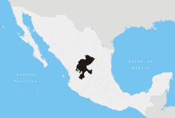
 Location of Cuauhtémoc within Zacatecas | |
|
Municipality of Cuauhtémoc Location of Cuauhtémoc within Zacatecas | |
| Coordinates: 22°27′N 102°21′W / 22.450°N 102.350°WCoordinates: 22°27′N 102°21′W / 22.450°N 102.350°W | |
| Country |
|
| State | Zacatecas |
| Municipal seat | San Pedro Piedra Gorda |
| Largest city | San Pedro Piedra Gorda |
| Municipality | May 25, 1869 |
| Government | |
| • Municipal President | Ángel Ruiz Zapata, PRD |
| Area | |
| • Total | 318 km2 (123 sq mi) |
| Elevation | 2,030 m (6,660 ft) |
| Population (2005) | |
| • Total | 11,275 |
| • Largest city | 7,701 San Pedro Piedra Gorda |
| Time zone | CST (UTC-6) |
| Postal Code | 98691 |
| Area code(s) | 458 |
Cuauhtémoc is one of the 58 municipalities in the Mexican state of Zacatecas. It is located in the central part of the state of Zacatecas and it is bounded by the municipalities of Ojocaliente, Luis Moya, and Genaro Codina; it also shares a border with the state of Aguascalientes. The municipality covers a total surface area of 318 square kilometers (123 sq mi).[1]
References
- ↑ "Cuauhtémoc" Archived September 30, 2007, at the Wayback Machine. INAFED: Enciclopedia de los Municipios de México.
Zacatecas (capital) | ||
| Municipalities and (municipal seats) |
|  |
This article is issued from Wikipedia - version of the 12/3/2016. The text is available under the Creative Commons Attribution/Share Alike but additional terms may apply for the media files.