Cyclone George
| Category 5 severe tropical cyclone (Aus scale) | |
|---|---|
| Category 3 (Saffir–Simpson scale) | |
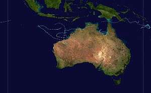
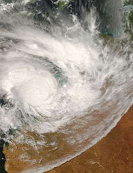 Severe Tropical Cyclone George on 8 March, a few hours before landfall. | |
| Formed | 26 February 2007 |
| Dissipated | 10 March 2007 |
| Highest winds |
10-minute sustained: 205 km/h (125 mph) 1-minute sustained: 205 km/h (125 mph) Gusts: 285 km/h (180 mph) |
| Lowest pressure | 902 hPa (mbar); 26.64 inHg |
| Fatalities | 55 total |
| Damage | $15.7 million (2007 USD) |
| Areas affected | Northern Territory, Western Australia |
| Part of the 2006–07 Australian region cyclone season | |
Severe Tropical Cyclone George was the most powerful Australian tropical cyclones on record, attaining a minimum barometric pressure of 902 mbar (hPa; 26.64 inHg). The cyclone formed on 2 March in the Northern Territory's Top End late in February, and intensified when it entered the Joseph Bonaparte Gulf, before crossing the northern coast of the Kimberley. It moved over the Indian Ocean, intensifying to a Category 4 cyclone, and eventually crossed the Pilbara coast just east of Port Hedland at peak intensity. After further analysis from the Bureau of Meteorology Cyclone George was reclassified to Category 5. It caused significant damage to the town of Port Hedland and numerous isolated mining camps around the town. Losses in Northern Territory amounted to at least A$12 million (US$9.5 million). Two people died and more than a dozen others were infected in a melioidosis outbreak following the Northern Territory floods. Insured damage in Western Australia amounted to A$8 million (US$6.2 million), and there were 3 fatalities.
Meteorological history
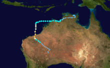
On 24th of February 2007, an area of low pressure began consolidating over the Arafura Sea. By 26 February, the Australian Bureau of Meteorology (BOM) warning centre in Darwin classified the system as a tropical low with its centre situated 230 km (140 mi) northwest of Nhulunbuy. Over the following days, the system meandered around the Top End region and showed signs of gradual organization. Initial forecasts depicted the low as moving gradually eastward and becoming a significant cyclone over the Gulf of Carpentaria; however, after approaching Milingimbi Island on 1 March, the system doubled back to the west in response to a subtropical ridge over central Australia.[1][2] Though overland, the cyclone remained well-organized (a typical occurrence for tropical lows over Top End). Deep convection blossomed on 2 March as it approached the Joseph Bonaparte Gulf.[1] Owing to favourable upper-level outflow and decreasing wind shear, the Joint Typhoon Warning Center (JTWC) issued a Tropical Cyclone Formation Alert for the system that day.[2] The agency estimated the formation of a tropical depression, assigning it the identifier 17S, by 00:00 UTC (9:30 a.m. ACST) on 3 March while it was still over land.[3] Hours later, the low emerged over the Gulf and acquired gale-force winds while situated 75 km (47 mi) south-southeast of Oenpelli.[1] In light of this, the Darwin warning centre initiated advisories on Tropical Cyclone George,[4] marking the first time since Cyclone Fay in 2004 that the Darwin office named a storm.[1]
George (gege) quickly intensified once offshore, with a very small banding eye of approximately 8 km (5.0 mi) in diameter appearing on SSMI satellite imagery,[2][5] and gained winds of 95 km/h (60 mph) by 18:00 UTC (3:00 a.m. AWST on 4 March).[1] The system subsequently made landfall in the Kimberley region of Western Australia at that intensity hours later.[4] Substantial structural degradation took place over land, with the eye feature dissipating,[2] and the BOM estimated the system to have briefly weakened to a tropical low before emerging over the extreme eastern Indian Ocean late on 4 March.[4] Once offshore, George regained tropical cyclone strength as it moved steadily west away from Australia. Intensification was slow due a lack of outflow and increased wind shear.[1] Over the following few days, most forecast models indicated that George would gradually turn to the south as it rounded the subtropical ridge and possibly strike areas between Exmouth and Onslow by 9 March. The models continued to indicate this scenario through 6 March, resulting in a high-confidence forecast from the Perth warning centre.[6]
However, on 7 March George took an abrupt, nearly 90 degree left turn through a weakness in the ridge and began moving almost due south.[1] This turn caught meteorologists almost entirely off-guard, with only the United Kingdom Met Office ensemble model depicting this scenario. Post-storm reviews of the forecasting failure pointed toward four factors that may have influenced George at the time but were not initialized by the models: the extratropical transition of Cyclone Humba well upstream over the Indian Ocean, a Fujiwhara interaction with Cyclone Jacob to the northwest, the Beta drift effect, and poorly represented monsoonal flow. Of these factors, the monsoonal flow was determined to have been the main cause in the poor track forecast as models did not capture the degree of influence of these winds on the cyclone.[6] This resulted in the forecast track for George having the greatest error of any cyclone in the Western Australian region in at least five years. The average error of 477 km (296 mi) at 48 hours was comparable to the average accuracy of forecasts in the 1980s.[4]
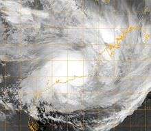
Coinciding with George's turn south was a notable improvement of environmental factors. Wind shear, previously inhibiting organization, began to decrease while a nearby upper-level low enhanced the system's outflow.[1] The favorable condition allowed for an increase in both strength and size, with both the BOM and JTWC estimating the cyclone to have attained hurricane-force winds by 12:00 UTC (8:00 p.m. AWST) on 7 March.[3][4][nb 1] By early on 8 March, George featured an area of gale-force winds spanning nearly 400 km (250 mi) across, significantly larger than average.[4] A large cloud-filled eye soon developed before a sudden period of rapid intensification ensued.[2][5] During this phase, the cyclone's eye steadily contracted to a minimum diameter of roughly 22 km (14 mi).[5] Between 09:00 and 10:00 UTC (5:00–6:00 p.m. AWST) on 8 March, George passed directly over Bedout Island.[1] As the eyewall moved over the island, a record-breaking ten-minute sustained wind speed of 194 km/h (121 mph) was measured. This marked the highest ten-minute wind measurement officially recorded in Australia. Based on the extreme winds measured on Bedout and additional intensification thereafter, George was estimated to have reached its peak intensity at 12:00 UTC (8:00 p.m. AWST) with winds of 205 km/h (125 mph) and an estimated barometric pressure of 902 mbar (hPa; 26.64 inHg).[4] Automated Dvorak classifications from the Cooperative Institute for Meteorological Satellite Studies at University of Wisconsin–Madison peaked at 6.8, equivalent to a high-end Category 4 on the Saffir–Simpson hurricane wind scale, as the storm moved ashore.[7]
At 10 p.m on 8 March, Cyclone George made landfall 50 kilometres (31 mi) north-east of Port Hedland.[8] When it made landfall, it was still at its peak intensity.[8] Damaging wind gusts of 154 kilometres per hour (96 mph) were recorded at Port Hedland Airport weather station just before 11 p.m.[9] The anemometer failed shortly afterwards.[9] At 00:12 a.m on 9 March, an air pressure reading of 962.7 hectopascals (28.43 inHg) was recorded at Port Hedland Airport; this was lowest recorded at the airport during the passage of the cyclone.[9] George weakened slowly while over land and it was downgraded to a Category 3 late on 9 March. The next day, the Tropical Cyclone Warning Centre in Perth issued its final warning for the system.
Preparations
Cyclone George resulted in numerous schools and ports in Port Hedland being closed down in order to deal with the severe cyclone.[10] Mining, Oil and Gas companies had to ultimately close in order to also deal with the threat of the imminent Cyclone. People were additionally evacuated from low lying levels near the sea, and moved either to higher ground, or further inland to Cyclone Shelters.[11]
Impact
Northern Territory
As a developing tropical low, George produced prolonged heavy, in some cases record-breaking, rain across much of Northern Territory in late February through early March.[12] The most prolific rains took place as the system strengthened and began moving away from the region. In a five-day span, numerous areas saw more than a month's worth of precipitation.[13] Several towns and cities saw single-day rainfall records for March shattered by the system most notably Jabiru Airport with 393.4 mm (15.49 in) falling on 1 March, more than three times the previous highest. Other places that broke daily records include Adelaide River, Black Point, Channel Island, Elizabeth Valley, Howard Springs, Mango Farm, Oenpelli, Territory Wildlife Farm, Thorak Cemetery, and Walker Creek. The tremendous rains also resulted in many areas seeing their wettest March on record.[12]
Widespread flooding resulted from the rains in the region, with some areas becoming isolated by 2 March.[14] Extensive damage was incurred by region's roadways, with losses reaching A$12 million (US$9.5 million).[nb 2] Officials referred to the effects of the flooding as the worst in 40 years.[17] Portions of the Kakadu and Arnhem highways were shut down, with the latter expected to remain so for a week.[14] Throughout the Top End region, a collective 101 bridges and roads were closed due to flooding.[18] Workers at the Ranger Uranium Mine in Jabiru were forced to camp out at the mine as floodwaters overtook the area.[14] The mine's pit was inundated and forced to shut down for nine days while processing had to be suspended for two weeks. The resulting loss in production cost Energy Resources of Australia 300 tonnes (330 tons) of uranium. According to resource analysts, the negative impacts of the flood in addition to lingering effects from Cyclone Monica in 2006 would result in a two percent decrease in the global supply of uranium by 2008.[19] Economic losses sustained by the Energy Resources of Australia were estimated to reach A$200 million (US$158 million).[20] At least one house nearby was submerged.[14]
Just south of Jabiru, 35 people were airlifted from the Gagudju Lodge in Cooinda.[21] Helicopters were used to drop food to personnel stranded at outstations in the Kakadu National Park.[14] Severe storms in the park spawned a rare tornado near the Mary River Ranger Station. The 300 m (980 ft) wide twister leveled trees and destroyed caravans along a 3 km (1.9 mi) path. In some cases, trees were even debarked.[22] Based on the damage, the tornado was estimated to have had winds between 230 and 270 km/h (140 and 170 mph).[1] Severe thunderstorms battered Darwin on 3 March with frequent lightning, torrential rain, and destructive wind gusts up to 120 km/h (75 mph). Downed trees and power lines left 10,000 residents without electricity and flooded roadways isolated some in suburban areas.[23][24] Flight delays were common at Darwin International Airport, while two had to be cancelled.[23] Four people in Adelaide River required rescue from their home. Debris from flooding in the town left main street and a nearby bridge impassible.[25]
The most severe flooding took place in Oenpelli which saw roughly 930 mm (37 in) of rain in less than a week.[26] Evacuation of 90 people from 47 homes in the town took place on 3 March as rising waters from the local billabong became contaminated with sewage.[25][27] Residents initially attempted to protect their homes with sandbags but waters rose too fast and over-topped the barrier.[28] Waters reached halfway up homes in the lowest lying areas, with high tide expected to reach 7.2 m (24 ft) on 4 March.[27] Waters began subsiding in the town by 6 March, though low-lying areas remained partially submerged.[29] More than 60 homes sustained flood-related damage.[26] The local school and its library sustained extensive damage, with the latter being damaged beyond repair.[29] An estimated 350 of the 1,400 cattle kept in paddocks near the community were swept away during the flood;[30] at least 70 were known to have drowned by 7 March.[31]
Western Australia
| Rank | Cyclone | Year | Min. pressure |
|---|---|---|---|
| 1 | Gwenda | 1999 | 900 hPa (26.58 inHg) |
| Inigo | 2003 | ||
| 3 | George | 2007 | 902 hPa (26.64 inHg) |
| 4 | Orson | 1989 | 904 hPa (26.70 inHg) |
| 5 | Theodore | 1994 | 910 hPa (26.87 inHg) |
| Vance | 1999 | ||
| Fay | 2004 | ||
| Glenda | 2006 | ||
| Source: Australian Bureau of Meteorology | |||
Cyclone George was the most powerful cyclone to hit Port Hedland since Cyclone Joan in 1975.[8] The cyclone's peak intensity of 902 hPa (26.64 inHg) with wind gusts of up to 285 kilometres per hour (177 mph) was estimated following Dvorak analysis of satellite imagery.[32]
Power and telephone lines were down in Port Hedland, many roofs and fences were torn down and trees were uprooted.[33] At least one house was destroyed.[34] The Pilbara region was declared a disaster zone, and the Australian Defence Force was on standby to provide extra help.[35] At around 10 p.m on 8 March, the Bureau of Meteorology's Port Hedland weather radar was damaged by the cyclone and was offline for nearly a day.[9] Tropical Cyclone Jacob struck almost the same area as George only three days later, although it was not as damaging or deadly as George. It did however cause some minor flooding.[36]
Three people were killed and twenty-eight others were injured as a result of the severe cyclone. One death and the majority of the people injured occurred at a Fortescue Metals Group camp,[37] about 100 km (62.13 mi) south of Port Hedland.[38] Strong winds and flooding delayed the rescue efforts for most of the day.[35] However, all injured workers were airlifted to the hospital in Port Hedland after the cyclone passed.[38] The deaths occurred when strong winds knocked over temporary accommodation shelters known as dongas. The second death occurred at Indee station, located between Port Hedland and the mining camp.[35] The man died from severe internal injuries while escaping from his wrecked donga, trying to seek help at the main station homestead.[39] A third death occurred when a man who was transferred to a Perth hospital on 11 March died due to the injuries received when the cyclone hit at the Fortescue camp.[40]
Aftermath
Northern Territory
Starting on 7 March, the Gunbulunya Health Clinic in Oenpelli began warning residents of a possible melioidosis outbreak resulting from the floods. They urged residents to wear shoes and wash their hands before eating to avoid infection.[41] More than a dozen people contracted the disease over the following weeks, with two dying as a result. Three others were hospitalized in the Royal Darwin Hospital.[42] Reconstruction of roads in and around Darwin began by 9 March; however, portions of the Arnhem Highway remained under water. The Department of Planning and Infrastructure stated that a 15 m (49 ft) bridge would have to be constructed over the West Alligator River where a culvert collapsed.[43] The A$1.2 million (US$950,000) bridge was completed on 5 April and allowed Arnhem Highway to completely re-open.[44] Repair work on roads continued for more than a month, with additional rains in the following weeks creating additional potholes.[17] A week after the floods, there was some concern over a delay in aid from the government; however, authorities assured that supplies would be provided in a timely manner once need assessments were complete.[45] The Salvation Army began collecting supplies for the 90 people rendered homeless by 13 March with additional requests for assistance made to the Australian Red Cross.[46] Shipments of supplies to Oenpelli began on 20 March, with a total of 14 flights scheduled over two days. The airlifts brought more than A$200,000 (US$158,000) worth of goods, consisting of mattresses, blankets, sheets, refrigerators, washing machines, and stoves, to the community.[47]
Western Australia

On 9 March, Prime Minister John Howard announced that persons injured by the storm or those whom lost their home would be eligible for funding through the Australian Government Disaster Recovery Payment program. The initiative ultimately provided 530 people with a collective A$630,000 (US$497,700) in aid.[48]
After Cyclone George struck the Pilbara coast, a relief fund was set up in order to help the victims of the storm. Mining companies, business, and residents all donated money to assist with the cause, and within 48 hours the town of Port Hedland was able to raise just over A$520,000 (US$410 in 2007; $469.00 2016 USD).[49] BHP Billiton also helped recover Port Hedland by giving the local government $1 million A$ each year which will fund for a large part of an enhancement scheme with the Western Australian State Government to improve the town's appearance. Schools in South Hedland remained closed due to safety concerns about the damage caused by cyclones George and Jacob until 19 March, after the local community joined in a massive clean-up.[50]
In commemoration of the deaths that took place, the Fortescue Metal Groups commissioned the McNally Newton Landscape Architects to construct a memorial in South Hedland. Acclaimed sculptor Ron Gomboc designed a 12 m (39 ft) twisted, steel monument for the project. The memorial was opened in March 2009, two years after the storm.[51]
Lawsuits
The Australian Workers' Union (AWU) launched a scathing attack on the Fortescue Metals Group Ltd, saying they were disgraced that no evacuation took place before the cyclone hit. The AWU were also concerned about the buildings at the campsite as they were only built to withstand a Category 2 cyclone. Almost all of the buildings located at the camp site were destroyed.[40] Fortescue and its subsidiary the Pilbara Infrastructure (TPI) were charged with a combined 18 counts of failing to provide or maintain a safe workplace over Cyclone George and appeared in Perth Magistrates Court.[52] The Magistrate dismissed all charges and when that decision was appealed to the Supreme Court of Western Australia the appeal was also dismissed, with Justice Stephen Hall finding that Fortescue had met their duty to provide a safe workplace by engaging "qualified and experienced experts" to manage the dongas.[53] Both courts had heard that the company contracted to build the dongas, NT Link, had given assurances to Fortescue that the dongas had been constructed to industry standards when it had not.[52] NT Link was granted immunity from prosecution in exchange for its testimony against Fortescue.[54]
See also
Notes
References
- 1 2 3 4 5 6 7 8 9 10 Gary Padgett; Kevin Boyle; Simon Clarke (26 May 2007). "Monthly Global Tropical Cyclone Summary: March 2007" (Report). Australia Severe Weather. Retrieved 1 January 2015.
- 1 2 3 4 5 "Tropical Cyclone George Joint Typhoon Warning Center Advisories". Joint Typhoon Warning Center. Australia Severe Weather. 9 March 2007. Retrieved 1 January 2015.
- 1 2 "Cyclone 17S (George) Best Track" (.TXT). Joint Typhoon Warning Center. United States Navy. 2008. Retrieved 1 January 2015.
- 1 2 3 4 5 6 7 Meteorological Aspects of Severe Tropical Cyclone George's Impact on the Pilbara (PDF). Perth Tropical Cyclone Warning Centre (Report). Bureau of Meteorology. 12 October 2007. Retrieved 2 January 2015.
- 1 2 3 "Australian Tropical Cyclone Database: Past Tropical Cyclone Tracks" (.CSV). Bureau of Meteorology. 8 January 2015. Retrieved 8 January 2015.
- 1 2 Jim Davidson (5 November 2007). Challenging Aspects of Severe Tropical Cyclone George's Track Forecasts (PDF). Bureau of Meteorology (Report). World Meteorological Organization. Retrieved 2 January 2015.
- ↑ "Tropical Cyclone 17S Automated Dvorak Classifications" (.TXT). Cooperative Institute for Meteorological Satellite Studies. University of Wisconsin–Madison. 9 March 2007. Retrieved 4 January 2015.
- 1 2 3 "Severe Tropical Cyclone George". Previous Cyclones. Bureau of Meteorology. Retrieved 26 November 2011.
- 1 2 3 4 "Meteorological Aspects of Severe Tropical Cyclone George's Impact on the Pilbara" (PDF). Bureau of Meteorology. Retrieved 27 November 2011.
- ↑ WA towns brace for cyclone, The Australian.
- ↑ Cyclone disrupts WA oil, gas, NEWS.com.au Business.
- 1 2 "Widespread flooding in the Top End while hot and wet in the south - Northern Territory in March 2007". Northern Territory Climate Services Centre. Bureau of Meteorology. 3 April 2007. Retrieved 4 January 2015.
- ↑ Julia Kogan (8 March 2007). "Month rain in five days". Darwin Palmerston Sun. p. 2. – via LexisNexis (subscription required)
- 1 2 3 4 5 Greg McClean (2 March 2007). "Miners stranded as floodwaters rise". Northern Territory News. p. 5. – via LexisNexis (subscription required)
- ↑ "US Dollar Per Australian Dollar". Data 360. 2011. Retrieved 6 January 2015.
- ↑ "What is a dollar worth?". Federal Reserve Bank of Minneapolis. 2016.
- 1 2 "Storms leave $12m road bill". Northern Territory News. 17 April 2007. p. 2. – via LexisNexis (subscription required)
- ↑ "101 roads, bridges closed". Northern Territory News. 10 March 2007. p. 5. – via LexisNexis (subscription required)
- ↑ Michael Vaughan (3 April 2007). "ERA's output hit by flooding". Australian Financial Review. p. 17. – via LexisNexis (subscription required)
- ↑ Jamie Freed (3 April 2007). "Heavy rains play havoc with ERA output". Sydney Morning Herald. p. 21. – via LexisNexis (subscription required)
- ↑ "Rainfall causes flooding in Oenpelli". Australian Broadcasting Corporation. 2 March 2007. – via LexisNexis (subscription required)
- ↑ "Tornado formed 3 weeks ago in Kakadu". Australian Broadcasting Corporation. 20 March 2007. Retrieved 10 January 2015.
- 1 2 Rebekah Cavanagh (3 March 2007). "Power out, rains cut roads". Northern Territory News. p. 7. – via LexisNexis (subscription required)
- ↑ "Storms douse Darwin, cut roads". Australian Broadcasting Corporation. 3 March 2007. – via LexisNexis (subscription required)
- 1 2 "Woman and children rescued from NT flood waters". Darwin, Australia: Australian Associated Press. 3 March 2007. – via LexisNexis (subscription required)
- 1 2 Northern Territory Disaster Risk Assessment (PDF) (Report). Government of Australia. 2013. p. 14. Retrieved 4 January 2015.
- 1 2 "Oenpelli braces for high tide". Sunday Territorian. 4 March 2007. p. 5. – via LexisNexis (subscription required)
- ↑ Rebekah Cavanagh (7 March 2007). "Family loses all in storm". Northern Territory News. p. 5. – via LexisNexis (subscription required)
- 1 2 Rebekah Cavanagh (6 March 2007). "Trail of damage in wake of late Wet". Northern Territory News. p. 4. – via LexisNexis (subscription required)
- ↑ "Oenpelli residents feared for their lives during flooding". Australian Broadcasting Corporation. 6 March 2007. – via LexisNexis (subscription required)
- ↑ "Cattle go missing in heavy floods". Northern Territory News. 7 March 2007. p. 5. – via LexisNexis (subscription required)
- ↑ "Meteorological Aspects of Severe Tropical Cyclone George's Impact on the Pilbara" (PDF). Bureau of Meteorology. 2007. p. 4. Retrieved 27 November 2011.
- ↑ Cyclone George, The Geelong Advertiser, 2007-03-09.
- ↑ "Three reported dead after WA cyclone". ABC News Online. 2007. Archived from the original on 2007-03-12. Retrieved 26 November 2011.
- 1 2 3 Deadly cyclone's fury not spent, The Daily Telegraph
- ↑ Tropical Cyclone Jacob Impacts, Australian Bureau of Meteorology, 2007-03-05.
- ↑ PM pledges extra funding for cyclone George victims, ABC News Online, 2007-03-09.
- 1 2 At least two dead in George's wake, The Golden Mail
- ↑ WA police launch probe into third cyclone death, ABC News Online, 2007-03-15.
- 1 2 Police to investigate cyclone deaths, ABC News Online, 2007-03-11.
- ↑ "Health warning for flooded oenpelli". Australian Broadcasting Corporation. 7 March 2007. Retrieved 4 January 2015.
- ↑ "NT flood disease kills 2". Australian Broadcasting Corporation. 17 March 2007. – via LexisNexis (subscription required)
- ↑ "NT floods bring $5m clean-up bill". Australian Broadcasting Corporation. 9 March 2007. – via LexisNexis (subscription required)
- ↑ "Highway re-opened". Northern Territory News. 5 April 2007. p. 3. – via LexisNexis (subscription required)
- ↑ "Govt denies delay in transporting emergency goods to oenpelli". Australian Broadcasting Corporation. 9 March 2007. Retrieved 4 January 2015.
- ↑ "Salvos work to assist in Oenpelli floods aftermath". Australian Broadcasting Corporation. 13 March 2007. – via LexisNexis (subscription required)
- ↑ "Flood relief airlifted into remote NT community". Australian Broadcasting Corporation. 20 March 2007. – via LexisNexis (subscription required)
- ↑ "Tropical Cyclone George 2007". Disaster Assist. Government of Australia. 4 November 2014. Retrieved 10 January 2015.
- ↑ Money pours into cyclone George relief fund, ABC News Online, 2007-03-16.
- ↑ BHP Billiton offers funds advancement for cyclone-hit Port Hedland, ABC News Online, 2007-03-19.
- ↑ "Cyclone George Memorial Dedicated" (PDF). Emerge Associates. March 2009. Retrieved 10 January 2015.
- 1 2 'No peace' for family after Fortescue cleared of cyclone deaths, WA Today, 2011-02-18.
- ↑ Worksafe cyclone appeal dismissed, Nine MSN, 2013-03-23.
- ↑ DLA Piper successfully defends Fortescue Metals Group against Cyclone George charges, DLA Piper, 2012-05-10.
External links
![]() Media related to Cyclone George at Wikimedia Commons
Media related to Cyclone George at Wikimedia Commons
- TC George Pilbara Impact Report from the Bureau of Meteorology.
Tropical cyclones of the 2006–07 Australian region cyclone season | ||
|---|---|---|
 | ||
| ||
| 1960s | |
|---|---|
| 1970s | |
| 1980s | |
| 1990s | |
| 2000s | |
| 2010s | |
| |