Daleville, Indiana
| Daleville | |
|---|---|
| Town | |
|
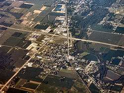
Daleville from above, looking southwest. | |
 | |
 Daleville | |
| Coordinates: 40°7′15″N 85°33′32″W / 40.12083°N 85.55889°WCoordinates: 40°7′15″N 85°33′32″W / 40.12083°N 85.55889°W | |
| Country | United States |
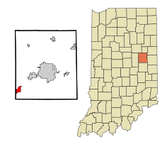
| State | Indiana |
| County | Delaware |
| Township | Salem |
| Area[1] | |
| • Total | 2.07 sq mi (5.36 km2) |
| • Land | 2.05 sq mi (5.31 km2) |
| • Water | 0.02 sq mi (0.05 km2) |
| Elevation | 912 ft (278 m) |
| Population (2010)[2] | |
| • Total | 1,647 |
| • Estimate (2012[3]) | 1,636 |
| • Density | 803.4/sq mi (310.2/km2) |
| Time zone | EST (UTC-5) |
| • Summer (DST) | EST (UTC-5) |
| ZIP code | 47334 |
| Area code(s) | 765 |
| FIPS code | 18-16642[4] |
| GNIS feature ID | 0433295[5] |
Daleville is a town in Salem Township, Delaware County, Indiana, United States. The population was 1,647 at the 2010 census. It is part of the Muncie, IN Metropolitan Statistical Area.[6]
History
Daleville was named for the Dale family, who settled at the site in the 1820s.[7] It was platted in 1838.[8]
Daleville is the newest town in Indiana, as it was officially incorporated as a town in 1982.[9]
Geography
Daleville is located at 40°07′15″N 85°33′32″W / 40.120747°N 85.558759°W.[10]
According to the 2010 census, Daleville has a total area of 2.07 square miles (5.36 km2), of which 2.05 square miles (5.31 km2) (or 99.03%) is land and 0.02 square miles (0.05 km2) (or 0.97%) is water.[1]
Demographics
| Historical population | |||
|---|---|---|---|
| Census | Pop. | %± | |
| 1880 | 297 | — | |
| 1990 | 1,681 | — | |
| 2000 | 1,658 | −1.4% | |
| 2010 | 1,647 | −0.7% | |
| Est. 2015 | 1,608 | [11] | −2.4% |
2010 census
As of the census[2] of 2010, there were 1,647 people, 671 households, and 457 families residing in the town. The population density was 803.4 inhabitants per square mile (310.2/km2). There were 716 housing units at an average density of 349.3 per square mile (134.9/km2). The racial makeup of the town was 97.6% White, 0.4% African American, 0.1% Native American, 0.7% Asian, 0.1% Pacific Islander, 0.1% from other races, and 1.0% from two or more races. Hispanic or Latino of any race were 0.5% of the population.
There were 671 households of which 30.8% had children under the age of 18 living with them, 50.4% were married couples living together, 12.1% had a female householder with no husband present, 5.7% had a male householder with no wife present, and 31.9% were non-families. 28.0% of all households were made up of individuals and 9.4% had someone living alone who was 65 years of age or older. The average household size was 2.45 and the average family size was 2.97.
The median age in the town was 40 years. 22.9% of residents were under the age of 18; 8.6% were between the ages of 18 and 24; 24.2% were from 25 to 44; 29.5% were from 45 to 64; and 14.7% were 65 years of age or older. The gender makeup of the town was 47.8% male and 52.2% female.
2000 census
As of the census[4] of 2000, there were 1,658 people, 650 households, and 453 families residing in the town. The population density was 832.4 people per square mile (321.7/km²). There were 688 housing units at an average density of 345.4 per square mile (133.5/km²). The racial makeup of the town was 98.97% White, 0.12% African American, 0.24% Native American, 0.06% Asian, 0.36% from other races, and 0.24% from two or more races. Hispanic or Latino of any race were 0.72% of the population.
There were 650 households out of which 35.2% had children under the age of 18 living with them, 57.2% were married couples living together, 9.5% had a female householder with no husband present, and 30.2% were non-families. 25.8% of all households were made up of individuals and 11.5% had someone living alone who was 65 years of age or older. The average household size was 2.55 and the average family size was 3.09.
In the town the population was spread out with 28.0% under the age of 18, 8.1% from 18 to 24, 30.3% from 25 to 44, 21.8% from 45 to 64, and 11.8% who were 65 years of age or older. The median age was 35 years. For every 100 females there were 90.6 males. For every 100 females age 18 and over, there were 89.7 males.
The median income for a household in the town was $40,592, and the median income for a family was $48,289. Males had a median income of $36,500 versus $23,182 for females. The per capita income for the town was $18,020. About 2.3% of families and 2.7% of the population were below the poverty line, including 1.6% of those under age 18 and 6.2% of those age 65 or over.
Education
Daleville Public Schools belong to the Daleville Community Schools school district. The district has one elementary school and one junior/senior high school. Students attend Daleville High School.[13][14]
John Dillinger
Commercial Bank was robbed by John Dillinger for $3,500 on July 17, 1933.
References
- 1 2 "G001 - Geographic Identifiers - 2010 Census Summary File 1". United States Census Bureau. Retrieved 2015-07-16.
- 1 2 "American FactFinder". United States Census Bureau. Retrieved 2012-12-11.
- ↑ "Population Estimates". United States Census Bureau. Retrieved 2013-06-25.
- 1 2 "American FactFinder". United States Census Bureau. Retrieved 2008-01-31.
- ↑ "US Board on Geographic Names". United States Geological Survey. 2007-10-25. Retrieved 2008-01-31.
- ↑ "Profile for Daleville, Indiana, IN". ePodunk. Retrieved September 25, 2012.
- ↑ Kemper, William Harrison (1908). A Twentieth Century History of Delaware County, Indiana, Volume 1. Lewis Publishing Company. p. 98.
- ↑ Lasley, Norma (2012). Delaware County. Arcadia Publishing. p. 21. ISBN 978-0-7385-9430-9.
- ↑ "Daleville, Indiana". City-Data.om. Retrieved September 25, 2012.
- ↑ "US Gazetteer files: 2010, 2000, and 1990". United States Census Bureau. 2011-02-12. Retrieved 2011-04-23.
- ↑ "Annual Estimates of the Resident Population for Incorporated Places: April 1, 2010 to July 1, 2015". Retrieved July 2, 2016.
- ↑ "Census of Population and Housing". Census.gov. Retrieved June 4, 2015.
- ↑ "Daleville Community Schools". Daleville Community Schools. Retrieved September 25, 2012.
- ↑ "Daleville Community Schools/". Great Schools, Inc. Retrieved September 25, 2012.
External links
| Wikimedia Commons has media related to Daleville, Indiana. |
- City-Data.com Comprehensive Statistical Data and more about Daleville
- Daleville Community Schools
Municipalities and communities of Delaware County, Indiana, United States | ||
|---|---|---|
| City | ||
| Towns | ||
| Townships | ||
| Unincorporated communities | ||
| Footnotes | ‡This populated place also has portions in an adjacent county or counties | |