Damar, Kansas
| Damar, Kansas | |
|---|---|
| City | |
|
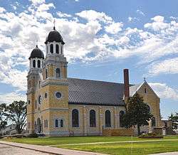
St. Joseph Catholic Church (2012) | |
 Location within Rooks County and Kansas | |
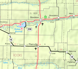 KDOT map of Rooks County (legend) | |
| Coordinates: 39°19′9″N 99°35′3″W / 39.31917°N 99.58417°WCoordinates: 39°19′9″N 99°35′3″W / 39.31917°N 99.58417°W | |
| Country | United States |
| State | Kansas |
| County | Rooks |
| Area[1] | |
| • Total | 0.19 sq mi (0.49 km2) |
| • Land | 0.19 sq mi (0.49 km2) |
| • Water | 0 sq mi (0 km2) |
| Elevation | 2,106 ft (642 m) |
| Population (2010)[2] | |
| • Total | 132 |
| • Estimate (2015)[3] | 132 |
| • Density | 690/sq mi (270/km2) |
| Time zone | CST (UTC-6) |
| • Summer (DST) | CDT (UTC-5) |
| ZIP code | 67632 |
| Area code | 785 |
| FIPS code | 20-16975 [4] |
| GNIS feature ID | 0472364 [5] |
Damar is a city in Rooks County, Kansas, United States. As of the 2010 census, the city population was 132.[6]
History
Damar was a station on the Union Pacific Railroad.[7] The first post office in Damar was established in 1894.[8]
The St. Joseph Catholic Church in Damar is on the National Register of Historic Places.
Geography
Damar is located at 39°19′9″N 99°35′3″W / 39.31917°N 99.58417°W (39.319144, -99.584156).[9] According to the United States Census Bureau, the city has a total area of 0.19 square miles (0.49 km2), all of it land.[1]
Climate
The climate in this area is characterized by hot, humid summers and generally mild to cool winters. According to the Köppen Climate Classification system, Damar has a humid subtropical climate, abbreviated "Cfa" on climate maps.[10]
Demographics
| Historical population | |||
|---|---|---|---|
| Census | Pop. | %± | |
| 1940 | 263 | — | |
| 1950 | 305 | 16.0% | |
| 1960 | 361 | 18.4% | |
| 1970 | 245 | −32.1% | |
| 1980 | 204 | −16.7% | |
| 1990 | 112 | −45.1% | |
| 2000 | 155 | 38.4% | |
| 2010 | 132 | −14.8% | |
| Est. 2015 | 132 | [3] | 0.0% |
| U.S. Decennial Census | |||
2010 census
As of the census[2] of 2010, there were 132 people, 58 households, and 34 families residing in the city. The population density was 694.7 inhabitants per square mile (268.2/km2). There were 91 housing units at an average density of 478.9 per square mile (184.9/km2). The racial makeup of the city was 97.7% White, 1.5% Asian, and 0.8% from two or more races.
There were 58 households of which 29.3% had children under the age of 18 living with them, 51.7% were married couples living together, 3.4% had a female householder with no husband present, 3.4% had a male householder with no wife present, and 41.4% were non-families. 34.5% of all households were made up of individuals and 18.9% had someone living alone who was 65 years of age or older. The average household size was 2.28 and the average family size was 2.97.
The median age in the city was 50 years. 23.5% of residents were under the age of 18; 7.5% were between the ages of 18 and 24; 14.3% were from 25 to 44; 34% were from 45 to 64; and 20.5% were 65 years of age or older. The gender makeup of the city was 46.2% male and 53.8% female.
2000 census
As of the census[4] of 2000, there were 155 people, 64 households, and 41 families residing in the city. The population density was 812.6 people per square mile (315.0/km²). There were 86 housing units at an average density of 450.8 per square mile (174.8/km²). The racial makeup of the city was 96.13% White and 3.87% African American.
There were 64 households out of which 28.1% had children under the age of 18 living with them, 54.7% were married couples living together, 4.7% had a female householder with no husband present, and 34.4% were non-families. 29.7% of all households were made up of individuals and 26.6% had someone living alone who was 65 years of age or older. The average household size was 2.42 and the average family size was 3.05.
In the city the population was spread out with 29.7% under the age of 18, 5.2% from 18 to 24, 23.9% from 25 to 44, 12.3% from 45 to 64, and 29.0% who were 65 years of age or older. The median age was 40 years. For every 100 females there were 93.8 males. For every 100 females age 18 and over, there were 81.7 males.
The median income for a household in the city was $27,917, and the median income for a family was $31,563. Males had a median income of $25,625 versus $9,583 for females. The per capita income for the city was $11,796. About 9.3% of families and 7.1% of the population were below the poverty line, including 1.8% of those under the age of eighteen and 4.2% of those sixty five or over.
See also
References
- 1 2 "US Gazetteer files 2010". United States Census Bureau. Archived from the original on January 24, 2012. Retrieved 2012-07-06.
- 1 2 "American FactFinder". United States Census Bureau. Retrieved 2012-07-06.
- 1 2 "Annual Estimates of the Resident Population for Incorporated Places: April 1, 2010 to July 1, 2015". Retrieved July 2, 2016.
- 1 2 "American FactFinder". United States Census Bureau. Archived from the original on September 11, 2013. Retrieved 2008-01-31.
- ↑ "US Board on Geographic Names". United States Geological Survey. 2007-10-25. Retrieved 2008-01-31.
- ↑ "2010 City Population and Housing Occupancy Status". U.S. Census Bureau. Archived from the original on July 21, 2011. Retrieved September 17, 2011.
- ↑ Blackmar, Frank Wilson (1912). Kansas: A Cyclopedia of State History, Embracing Events, Institutions, Industries, Counties, Cities, Towns, Prominent Persons, Etc. Standard Publishing Company. p. 491.
- ↑ "Kansas Post Offices, 1828-1961". Kansas Historical Society. Archived from the original on October 9, 2013. Retrieved 22 June 2014.
- ↑ "US Gazetteer files: 2010, 2000, and 1990". United States Census Bureau. 2011-02-12. Retrieved 2011-04-23.
- ↑ Climate Summary for Damar, Kansas
External links
| Wikimedia Commons has media related to Damar, Kansas. |
- City
- Other
- Maps
- Damar City Map, KDOT
Municipalities and communities of Rooks County, Kansas, United States | ||
|---|---|---|
| Cities | 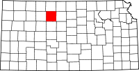 | |
| Unincorporated community | ||