Webster, Kansas
| Webster, Kansas | |
|---|---|
| Unincorporated community | |
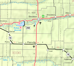 KDOT map of Rooks County (legend) | |
 Webster | |
| Coordinates: 39°23′13″N 99°25′04″W / 39.38694°N 99.41778°WCoordinates: 39°23′13″N 99°25′04″W / 39.38694°N 99.41778°W | |
| Country | United States |
| State | Kansas |
| County | Rooks |
| Township | Township 6 |
| Founded | 1885 |
| Elevation | 1,937 ft (590 m) |
| Time zone | Central (CST) (UTC-6) |
| • Summer (DST) | CDT (UTC-5) |
| ZIP code | 67669 |
| Area code(s) | 785 |
| GNIS feature ID | 484592[1] |
Webster is an unincorporated community in Rooks County, Kansas, United States.[2]
History
Webster Dam was named after the former town of Webster which was founded in 1885. The town was re-located two miles southeast of the original location. Many residents however moved to other places. It was bypassed by US Route 24 and since the late 1960s the new Webster has withered becoming a small village. It contain five resident families and two vacation homes. The former church and school are now private property. Reportedly when the Reservoir water is low enough, you can still walk the streets of old Webster.[3]
Geography
Webster is located at 39°23′13″N 99°25′04″W / 39.38694°N 99.41778°W (39.386944, -99.417778) at an elevation of 1,937 feet (590 m). It lies approximately 0.5 miles (0.80 km) south-southeast of Webster Dam in the Smoky Hills region of the Great Plains.[4][5] Webster is 0.3 miles (0.48 km) east of Kansas Highway 258, 2.5 miles (4.0 km) south of U.S. Route 24, and roughly 8 miles (13 km) west-southwest of Stockton, the county seat.[4]
The original site of Webster was located at 39°24′06″N 99°26′09″W / 39.40167°N 99.43583°W (39.4016756, -99.4359370), a location now submerged beneath Webster Reservoir. The site had an elevation of 1,893 feet (577 m).[1]
Transportation
Webster lies at the intersection of two unpaved county roads: 11 Road, which runs north-south, and M Terrace, which runs east-west.[4]
References
- 1 2 "Webster". Geographic Names Information System. United States Geological Survey. Retrieved 2015-11-19.
- ↑ "General Highway Map - Rooks County, Kansas" (PDF). Kansas Department of Transportation. 1980. Retrieved 2015-11-19.
- ↑ Lindsey, Jean (2010). "History of Webster". Solomon Valley Highway 24 Heritage Alliance. State Library of Kansas. Archived from the original on April 7, 2014. Retrieved 2014-06-24.
- 1 2 3 "General Highway Map - Rooks County, Kansas". Kansas Department of Transportation. January 2010. Retrieved 2015-11-19.
- ↑ "2003-2004 Official Transportation Map" (PDF). Kansas Department of Transportation. 2003. Retrieved 2015-11-19.
External links
Municipalities and communities of Rooks County, Kansas, United States | ||
|---|---|---|
| Cities | 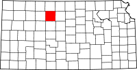 | |
| Unincorporated community | ||