Deir Abu Mash'al
| Deir Abu Mash'al | |
|---|---|
| Other transcription(s) | |
| • Arabic | دير ابو مشعل |
|
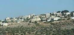
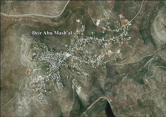
Deir Abu Mash'al | |
 Deir Abu Mash'al Location of Deir Abu Mash'al within the Palestinian territories | |
| Coordinates: 31°59′54.05″N 35°04′06.10″E / 31.9983472°N 35.0683611°ECoordinates: 31°59′54.05″N 35°04′06.10″E / 31.9983472°N 35.0683611°E | |
| Governorate | Ramallah & al-Bireh |
| Government | |
| • Type | Municipality |
| • Head of Municipality | Ibrahim Mohammad Yousi Zhran[1] |
| Population (2007) | |
| • Jurisdiction | 3,522 |
Deir Abu Mash'al (Arabic: دير ابو مشعل) is a Palestinian village in the Ramallah and al-Bireh Governorate, located 24 kilometers (15 mi) west of Ramallah in the northern West Bank. According to the Palestinian Central Bureau of Statistics (PCBS), the village had a population of approximately 3,522 inhabitants in 2007.[2]
References
- ↑ West Bank Local Elections ( Round two)- Successful candidates by local authority, gender and No. of votes obtained, Deir Abu Mish'al p 22
- ↑ 2007 PCBS Census. Palestinian Central Bureau of Statistics. p.113.
Bibliography
| Wikimedia Commons has media related to Deir Abu Mash'al. |
- Barron, J. B., ed. (1923). Palestine: Report and General Abstracts of the Census of 1922. Government of Palestine.
- Conder, Claude Reignier; Kitchener, H. H. (1882). The Survey of Western Palestine: Memoirs of the Topography, Orography, Hydrography, and Archaeology. 2. London: Committee of the Palestine Exploration Fund. (pp. 290, 310)
- Ellenblum, Ronnie (2003). Frankish Rural Settlement in the Latin Kingdom of Jerusalem. Cambridge University Press. ISBN 0521521874. External link in
|title=(help) p. 130 - Finkelstein, Israel; Lederman, Zvi, eds. (1997). Highlands of many cultures. Tel Aviv: Institute of Archaeology of Tel Aviv University Publications Section. ISBN 965-440-007-3. (p. 201 )
- Guérin, Victor (1875). Description Géographique Historique et Archéologique de la Palestine (in French). 2: Samarie, pt. 2. Paris: L'Imprimerie Nationale. (Guérin, 1875, pp. 118-119)
- Hadawi, Sami (1970). Village Statistics of 1945: A Classification of Land and Area ownership in Palestine. Palestine Liberation Organization Research Center.
- Hütteroth, Wolf-Dieter; Abdulfattah, Kamal (1977). Historical Geography of Palestine, Transjordan and Southern Syria in the Late 16th Century. Erlanger Geographische Arbeiten, Sonderband 5. Erlangen, Germany: Vorstand der Fränkischen Geographischen Gesellschaft. ISBN 3-920405-41-2. (p. 114)
- Mills, E., ed. (1932). Census of Palestine 1931. Population of Villages, Towns and Administrative Areas. Jerusalem: Government of Palestine.
- Palmer, E. H. (1881). The Survey of Western Palestine: Arabic and English Name Lists Collected During the Survey by Lieutenants Conder and Kitchener, R. E. Transliterated and Explained by E.H. Palmer. Committee of the Palestine Exploration Fund. (p. 228)
- Pringle, Denys (1997). Secular buildings in the Crusader Kingdom of Jerusalem: an archaeological Gazetter. Cambridge University Press. ISBN 0521 46010 7. (p. 46)
- Robinson, Edward; Smith, Eli (1841). Biblical Researches in Palestine, Mount Sinai and Arabia Petraea: A Journal of Travels in the year 1838. 2. Boston: Crocker & Brewster. (p. 133)
- Robinson, Edward; Smith, Eli (1841). Biblical Researches in Palestine, Mount Sinai and Arabia Petraea: A Journal of Travels in the year 1838. 3. Boston: Crocker & Brewster. (pp. 58, 66)
- Röhricht, Reinhold (1893). (RRH) Regesta regni Hierosolymitani (MXCVII-MCCXCI) (in Latin). Berlin: Libraria Academica Wageriana. (Röhricht, 1893, RHH, p. 113, No. 433)
External links
- Welcome To Dayr Abu Mash'al
- SWP map XIV, IAA
- SWP map 14, Wikimedia commons
- Deir Abu Mash'al Village (Fact Sheet), Applied Research Institute - Jerusalem (ARIJ)
- Deir Abu Mash'al Village Profile, Applied Research Institute - Jerusalem (ARIJ)
- Deir Abu Mash'al arael photo, Applied Research Institute - Jerusalem (ARIJ)
| Cities |  | |
|---|---|---|
| Municipalities |
| |
| Village councils |
| |
| Refugee camps | ||
This article is issued from Wikipedia - version of the 8/12/2016. The text is available under the Creative Commons Attribution/Share Alike but additional terms may apply for the media files.