Dighton, Massachusetts
| Dighton, Massachusetts | |||
|---|---|---|---|
| Town | |||
|
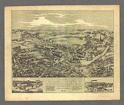
View of North Dighton Village in 1881 | |||
| |||
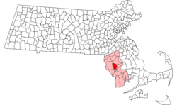 Location in Bristol County in Massachusetts | |||
| Coordinates: 41°48′50″N 71°07′15″W / 41.81389°N 71.12083°WCoordinates: 41°48′50″N 71°07′15″W / 41.81389°N 71.12083°W | |||
| Country | United States | ||
| State | Massachusetts | ||
| County | Bristol | ||
| Deeded | 1672[1] | ||
| Incorporated | 1712[1] | ||
| Government | |||
| • Type | Open town meeting | ||
| Area | |||
| • Total | 22.6 sq mi (58.5 km2) | ||
| • Land | 22.0 sq mi (57.0 km2) | ||
| • Water | 0.6 sq mi (1.5 km2) | ||
| Elevation | 19 ft (6 m) | ||
| Population (2010) | |||
| • Total | 7,086 | ||
| • Density | 310/sq mi (120/km2) | ||
| Time zone | Eastern (UTC-5) | ||
| • Summer (DST) | Eastern (UTC-4) | ||
| ZIP code | 02715 / 02764 (North Dighton) | ||
| Area code(s) | 508 / 774 | ||
| FIPS code | 25-16950 | ||
| GNIS feature ID | 0618280 | ||
| Website |
www | ||

Dighton is a town in Bristol County, Massachusetts, United States. The population was 7,086 at the 2010 census.[2] The town is located on the western shore of the Taunton River in the southeastern part of the state.
History
Dighton was originally part of Taunton's South Purchase and other surrounding towns. It was separated in 1672,[1] officially incorporated in 1712.[3] It was named for Frances Dighton Williams, wife of Richard Williams, a town elder.[4] At the time of incorporation, the town included land on both sides of the Taunton River, including the land of Assonet Neck, which includes Dighton Rock, a rock found in the shallows of the river which includes cryptic carvings whose origins are debated to this day. However, in 1799, that land on the east bank of the river was annexed by Berkley, thus giving that town the claim of being the home of the rock.
As it was located at the beginning of the tidewater of the river, Dighton was a shipbuilding community, and even had status as a port of call. Because of this, and its centralized location, it became a shipping hub for southeastern Massachusetts. There were also cotton mills, manufacturers and farming concerns in the town. With time, however, many of these industries left, leaving the town as a rural suburban community with some small farms.
Geography
According to the United States Census Bureau, the town has a total area of 22.6 square miles (58.5 km2), of which 22.0 square miles (57.0 km2) is land and 0.58 square miles (1.5 km2), or 2.56%, is water.[2]
Dighton is bordered by Rehoboth to the west, Swansea to the southwest, Somerset to the south, the Taunton River and the town of Berkley to the east, and the city of Taunton to the north. In addition to being bordered by the Taunton River, it also is bordered by the Three Mile River, a tributary which empties into the Taunton along the northeast border of town. The town is also crossed by the Segreganset River, another tributary of the Taunton which flows through the center of town, as well as several smaller brooks. The highest point in the town is in its northwest corner, where the elevation rises above 236 feet (72 m) above sea level.[5]
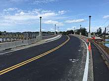
Dighton is the site of the Berkley–Dighton Bridge, originally a one-lane bridge built in the 1890s as a link between Center Street in Dighton and Elm Street in Berkley. It is the only span crossing the Taunton River between the Brightman Street Bridge between Somerset and Fall River, and the Plain Street Bridge in Taunton, a drive of 12 1⁄2 miles (20 km) (and 4 mi or 6 km south of the Plain Street Bridge). In 2010, the old bridge was demolished and a temporary bridge handled traffic as a new bridge was built. In August 2015 a new two-lane bridge opened to traffic.
Dighton's localities are Chestnut Tree Corner, Dighton, Dighton Rock State Park, North Dighton, Segreganset, South Dighton and Wheeler's Corner.
Demographics
| Historical population | ||
|---|---|---|
| Year | Pop. | ±% |
| 1850 | 1,641 | — |
| 1860 | 1,733 | +5.6% |
| 1870 | 1,817 | +4.8% |
| 1880 | 1,791 | −1.4% |
| 1890 | 1,880 | +5.0% |
| 1900 | 1,802 | −4.1% |
| 1910 | 2,235 | +24.0% |
| 1920 | 2,574 | +15.2% |
| 1930 | 3,147 | +22.3% |
| 1940 | 2,983 | −5.2% |
| 1950 | 2,950 | −1.1% |
| 1960 | 3,769 | +27.8% |
| 1970 | 4,667 | +23.8% |
| 1980 | 5,352 | +14.7% |
| 1990 | 5,631 | +5.2% |
| 2000 | 6,175 | +9.7% |
| 2010 | 7,086 | +14.8% |
Source: United States Census records and Population Estimates Program data.[6][7][8][9][10][11][12][13][14][15] | ||
As of the census[16] of 2000, there were 6,175 people, 2,201 households, and 1,718 families residing in the town. The population density was 275.9 people per square mile (106.5/km²). There were 2,280 housing units at an average density of 101.9 per square mile (39.3/km²). The racial makeup of the town was 97.80% White, 0.53% African American, 0.19% Native American, 0.49% Asian, 0.02% Pacific Islander, 0.28% from other races, and 0.70% from two or more races. Hispanic or Latino of any race were 1.07% of the population.
There were 2,201 households out of which 37.4% had children under the age of 18 living with them, 64.5% were married couples living together, 9.9% had a female householder with no husband present, and 21.9% were non-families. 18.8% of all households were made up of individuals and 9.7% had someone living alone who was 65 years of age or older. The average household size was 2.78 and the average family size was 3.17.
In the town the population was spread out with 26.1% under the age of 18, 6.3% from 18 to 24, 30.4% from 25 to 44, 24.3% from 45 to 64, and 12.8% who were 65 years of age or older. The median age was 38 years. For every 100 females there were 96.8 males. For every 100 females age 18 and over, there were 92.4 males.
The median income for a household in the town was $58,600, and the median income for a family was $64,792. Males had a median income of $41,427 versus $28,250 for females. The per capita income for the town was $22,600. About 1.0% of families and 2.6% of the population were below the poverty line, including 3.8% of those under age 18 and 1.2% of those age 65 or over.
Arts and culture
Annual cultural events
Dighton is home of the Cow Chip Festival. The Dighton Lions Club hosts the event. Every June a traveling carnival comes and sets up behind the Town Hall. Fireworks have been a recent addition to the festival. There are rides and a carnival mid-way along with food, musical performances, a lawn tractor pull, woodsman competition pony rides and the chicken BBQ. The name was given to it because they set up squares on the field behind the town hall. They place cows out on the enclosed squares. People then place bets on the square that they believe will be defecated on first by one of the cows.[17]
Parks and recreation
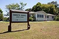
Sweets Knoll State Park is a fifty-six acre park located in Dighton.[18] It was purchased in June 2009, and includes two miles of old railroad bed which may be adapted into a walking and biking path, picnic areas, a small boat launch, and fishing.[18]
Government
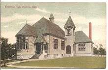
Dighton is governed by an open town meeting led by a board of selectmen. The town has a central police station along Route 138 by the banks of the Segreganset River, separate post offices and fire departments near the center of town and North Dighton, and the Dighton Public Library at the center of town. Dighton has a conservation area and a small park next to the town hall near the intersection of Center Street and Route 138.
Dighton is located in the Fifth Bristol state representative district, which includes Somerset and parts of Swansea and Taunton. The town is represented in the state senate in the First Plymouth and Bristol district, which includes the towns of Berkley, Bridgewater, Carver, Marion, Middleborough, Raynham, Taunton and Wareham. Dighton is patrolled by the Middleboro Barracks (D4) of the Massachusetts State Police. On the national level, the town is part of Massachusetts Congressional District 4, which is represented by Joe Kennedy. The state's junior (Class I) Senator is Ed Markey and the state's senior (Class II) Senator is Elizabeth Warren.
Education
Dighton and its neighboring town Rehoboth comprise one school district, the Dighton-Rehoboth Regional School District. It was founded in 1987 to oversee the schools of both towns. The high school, Dighton-Rehoboth Regional High School, was founded in 1958 to serve both towns. The school itself is located in North Dighton, mere yards away from the Rehoboth town line. Its athletics teams are known as the Falcons, and its colors are green and gold. The Dighton Middle and Elementary Schools are located near the corner of Center Street and Somerset Avenue (Route 138) at the center of town.[19][20]
The town is also the home of Bristol County Agricultural High School. The school operates a large farm along the banks of the Taunton River at its Center Street location.[21] The town does not have any affiliation with a regional vocational school system, the closest one being Bristol-Plymouth Regional Technical School, located in Taunton, Massachusetts.[22]
Library
Dighton is served by the Dighton Public Library. As of December 2009, the Library Director was Jocelyn Tavares.[23]
Historic places
Notable people
- Samuel Shaw (1768 –1827), United States Representative from Vermont[24]
See also
References
- 1 2 3 "Dighton Massachusetts Town Website". Dighton Massachusetts Town Website. Retrieved December 5, 2012.
- 1 2 "Geographic Identifiers: 2010 Demographic Profile Data (G001): Dighton town, Bristol County, Massachusetts". U.S. Census Bureau, American Factfinder. Retrieved February 5, 2013.
- ↑ "Dighton Massachusetts". City-Data.com. Retrieved November 10, 2012.
- ↑ Gannett, Henry (1905). The Origin of Certain Place Names in the United States. Govt. Print. Off. p. 106.
- ↑ U.S. Geological Survey Taunton, MA 7.5 by 15-minute quadrangle, 1987.
- ↑ "TOTAL POPULATION (P1), 2010 Census Summary File 1". American FactFinder, All County Subdivisions within Massachusetts. United States Census Bureau. 2010.
- ↑ "Massachusetts by Place and County Subdivision - GCT-T1. Population Estimates". United States Census Bureau. Retrieved July 12, 2011.
- ↑ "1990 Census of Population, General Population Characteristics: Massachusetts" (PDF). US Census Bureau. December 1990. Table 76: General Characteristics of Persons, Households, and Families: 1990. 1990 CP-1-23. Retrieved July 12, 2011.
- ↑ "1980 Census of the Population, Number of Inhabitants: Massachusetts" (PDF). US Census Bureau. December 1981. Table 4. Populations of County Subdivisions: 1960 to 1980. PC80-1-A23. Retrieved July 12, 2011.
- ↑ "1950 Census of Population" (PDF). Bureau of the Census. 1952. Section 6, Pages 21-10 and 21-11, Massachusetts Table 6. Population of Counties by Minor Civil Divisions: 1930 to 1950. Retrieved July 12, 2011.
- ↑ "1920 Census of Population" (PDF). Bureau of the Census. Number of Inhabitants, by Counties and Minor Civil Divisions. Pages 21-5 through 21-7. Massachusetts Table 2. Population of Counties by Minor Civil Divisions: 1920, 1910, and 1920. Retrieved July 12, 2011.
- ↑ "1890 Census of the Population" (PDF). Department of the Interior, Census Office. Pages 179 through 182. Massachusetts Table 5. Population of States and Territories by Minor Civil Divisions: 1880 and 1890. Retrieved July 12, 2011.
- ↑ "1870 Census of the Population" (PDF). Department of the Interior, Census Office. 1872. Pages 217 through 220. Table IX. Population of Minor Civil Divisions, &c. Massachusetts. Retrieved July 12, 2011.
- ↑ "1860 Census" (PDF). Department of the Interior, Census Office. 1864. Pages 220 through 226. State of Massachusetts Table No. 3. Populations of Cities, Towns, &c. Retrieved July 12, 2011.
- ↑ "1850 Census" (PDF). Department of the Interior, Census Office. 1854. Pages 338 through 393. Populations of Cities, Towns, &c. Retrieved July 12, 2011.
- ↑ "American FactFinder". United States Census Bureau. Retrieved 2008-01-31.
- ↑ Cow Chip festival classic for Dighton - Taunton, MA - The Taunton Gazette
- 1 2 Miller, Kendra Leigh (July 18, 2010). "'Idyllic' spot in Dighton is now a state park". The Herald News. GateHouse Media, Inc. Retrieved 1 December 2012.
- ↑ "Dighton-Rehoboth Regional School District". Dighton-Rehoboth Regional School District. Retrieved November 10, 2012.
- ↑ "Dighton-Rehoboth Regional School District". Massachusetts School Building Authority. Retrieved November 10, 2012.
- ↑ "Dighton-Rehoboth Regional School District". Bristol County Agricultural High School. Retrieved November 10, 2012.
- ↑ "Bristol-Plymouth Regional Technical School". Bristol-Plymouth Regional Technical School. Retrieved November 10, 2012.
- ↑ Library staff, retrieved 2009-12-19
- ↑ "SHAW, Samuel, (1768 - 1827)". Biographical Directory of the United States Congress. Retrieved November 14, 2012.
External links
| Wikivoyage has a travel guide for Dighton (Massachusetts). |
| Wikimedia Commons has media related to Dighton, Massachusetts. |
- Town of Dighton official website
- Dighton.com, community website
- Dighton Public Library
- Dighton Water District
- Dighton Art Association
- Dighton-Rehoboth Regional School District
- Bristol County Agricultural High School
- City-Data.com
- ePodunk: Profile for Dighton Massachusetts
Municipalities and communities of Bristol County, Massachusetts, United States | ||
|---|---|---|
| Cities |  | |
| Towns | ||
| CDPs | ||
| Other villages | ||
| Ghost town | ||