Norton, Massachusetts
| Norton, Massachusetts | ||
|---|---|---|
| Town | ||
|
Norton Town Common | ||
| ||
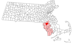 Location in Bristol County in Massachusetts | ||
| Coordinates: 41°58′00″N 71°11′15″W / 41.96667°N 71.18750°WCoordinates: 41°58′00″N 71°11′15″W / 41.96667°N 71.18750°W | ||
| Country | United States | |
| State | Massachusetts | |
| County | Bristol | |
| Settled | 1669 | |
| Incorporated | 1711 | |
| Government | ||
| • Type | Open town meeting | |
| Area | ||
| • Total | 29.8 sq mi (77.2 km2) | |
| • Land | 28.7 sq mi (74.4 km2) | |
| • Water | 1.1 sq mi (2.9 km2) | |
| Elevation | 105 ft (32 m) | |
| Population (2010) | ||
| • Total | 19,031 | |
| • Density | 640/sq mi (250/km2) | |
| Time zone | Eastern (UTC-5) | |
| • Summer (DST) | Eastern (UTC-4) | |
| ZIP code | 02766 | |
| Area code(s) | 508/774 | |
| FIPS code | 25-49970 | |
| GNIS feature ID | 0619436 | |
| Website | www.nortonma.org | |

Norton is a town in Bristol County, Massachusetts, United States, and contains the village of Norton Center. The population was 19,031 at the 2010 census.[1] Home of Wheaton College, Norton hosts the Deutsche Bank Championship as well as a tournament of the PGA Tour held annually on the weekend preceding the Labor Day holiday at the TPC Boston golf club.
History
Norton was first settled in 1669 and was called North Taunton for its location on the northern border of Taunton, Massachusetts. The town was renamed "Norton"—after Norton, Oxfordshire, England, where many early settlers had originated[2]—when the town was officially established on March 17, 1710. Parts of Norton were originally established as Easton on December 21, 1725, and as Mansfield on April 26, 1770.[3]
Metacomet, the Wampanoag Indian sachem also known as "King Phillip", is said to have hidden in a cave here near the end of King Philip's War before meeting his death in Hockomock Swamp. According to one source, "Every Norton school child has been entertained with the legend of King Phillip's Cave."[4]
The bandstand within the town center was originally erected using donated funds during the first Gulf War, in honor of the veterans who served from Norton.
Norton is a small but growing town. In elementary school, students were told the story of the "Devil's Foot Print," where James Wetherall sold his soul to the devil. The devil's foot print can be seen at Norton's Joseph C. Solmonese Elementary School. Every 26 years, the school unburies a time capsule, the last of which was buried in 1999. The time capsule will be opened next in 2026. The Sun Chronicle describes:
So it was in December 1997, when a traffic light was installed at the intersection of routes 123 and 140 in Norton. It was the town's first full traffic light and, in a manner of speaking, it declared "Norton isn't Mayberry anymore."[5]
Norton is also a location in the claimed paranormal Bridgewater Triangle.
.jpg)
Geography
According to the United States Census Bureau, the town has a total area of 29.8 square miles (77 km2), of which 28.7 square miles (74 km2) is land and 1.1 square miles (2.8 km2), or 3.72%, is water. Norton is generally low and swampy. The waters of the area are fed by the Wading River and the Canoe River, both of which feed into the Taunton River downstream. The two largest bodies of water in town are the Norton Reservoir, north of the center of town, and Winnecunnet Pond on the east (on the north side of I-495), which is fed by the Canoe River and feeds into the Mill River.
The town, an irregular polygon generally oriented from northeast to southwest, is bordered by Easton to the northeast, Taunton to the southeast, Rehoboth to the south, Attleboro to the southwest, and Mansfield to the northwest.
Transportation
The town is bisected southeast to northwest by Interstate 495, as well as Massachusetts Route 140 from north to south and Massachusetts Route 123 from southwest to northeast. Interstate 495's Exit 10 links the highway with Route 123. Exit 9 (Bay Street, Taunton) and Exit 11 (Route 140, Mansfield/Norton) are just over the town lines. Route 140 and Route 123 intersect at the center of town, by the town green. Although it is not officially signed as such, many fans attending concerts and events at the Comcast Center, formerly the Tweeter Center, and originally The Great Woods Center for the Performing Arts, just over the line in Mansfield along Route 140, reach the venue by driving along Route 123 to Route 140. The town is also a part of the Greater Attleboro Taunton Regional Transit Authority (or GATRA) bus line. The nearest MBTA station is Mansfield.
Demographics
| Historical population | ||
|---|---|---|
| Year | Pop. | ±% |
| 1850 | 1,966 | — |
| 1860 | 1,848 | −6.0% |
| 1870 | 1,821 | −1.5% |
| 1880 | 1,782 | −2.1% |
| 1890 | 1,785 | +0.2% |
| 1900 | 1,826 | +2.3% |
| 1910 | 2,544 | +39.3% |
| 1920 | 2,374 | −6.7% |
| 1930 | 2,737 | +15.3% |
| 1940 | 3,107 | +13.5% |
| 1950 | 4,401 | +41.6% |
| 1960 | 6,818 | +54.9% |
| 1970 | 9,487 | +39.1% |
| 1980 | 12,690 | +33.8% |
| 1990 | 14,265 | +12.4% |
| 2000 | 18,036 | +26.4% |
| 2010 | 19,031 | +5.5% |
Source: United States Census records and Population Estimates Program data.[6][7][8][9][10][11][12][13][14][15] | ||
As of the census[1] of 2000, there were 18,036 people, 5,872 households, and 4,474 families residing in the town. These residents are often referred to as either "Nortonites" or "Nortonians", though the term "Norts" is often used in colloquial context. The population density was 628.3 people per square mile (242.6/km²). There were 5,961 housing units at an average density of 207.7 per square mile (80.2/km²). The racial makeup of the town was 92.15% White, 1.16% African American, 0.13% Native American, 1.00% Asian, 0.01% Pacific Islander, 4.47% from other races, and 1.08% from two or more races. Hispanic or Latino of any race were 1.14% of the population.
There were 5,872 households out of which 42.3% had children under the age of 18 living with them, 61.8% were married couples living together, 10.8% had a female householder with no husband present, and 23.8% were non-families. 19.3% of all households were made up of individuals and 6.9% had someone living alone who was 65 years of age or older. The average household size was 2.79 and the average family size was 3.22.
In the town the population was spread out with 27.0% under the age of 18, 12.6% from 18 to 24, 32.2% from 25 to 44, 20.5% from 45 to 64, and 7.8% who were 65 years of age or older. The median age was 33 years. For every 100 females there were 90.7 males. For every 100 females age 18 and over, there were 86.1 males.
According to a 2016estimate, the median income for a household in the town was $80,806, and the median income for a family in 2016 was estimated at $104,176.[16][17] Males had a median income of $51,133 versus $33,149 for females. The per capita income for the town was $23,876. About 2.2% of families and 4.0% of the population were below the poverty line, including 2.9% of those under age 18 and 12.9% of those age 65 or over.
Government
State and national government
The town is a part of three separate state representative districts; precinct one belonging to the Fourth Bristol district (which includes all of Rehoboth, Seekonk and part of Swansea), precinct two belonging to the Fourteenth Bristol district (which includes parts of North Attleborough, Attleboro and Mansfield as well), and precincts three through five belonging to the First Bristol district (whose district includes Mansfield Center and Foxborough). The town is a part of the state senate district of the Bristol and Norfolk district, stretching from Dover to the north to Rehoboth and Seekonk to the south. James Timilty serves as State Senator for the Bristol & Norfolk district. Norton is patrolled by Troop H (Metro Boston District), Third (Foxborough) Barracks of the Massachusetts State Police.
On the national level, the town is part of Massachusetts Congressional District 4, which is represented by Joseph P. Kennedy III. The state's senior Senator, newly elected in 2012, is Elizabeth Warren and the state's junior Senator is currently Ed Markey.
Town government and services
The town has an open town meeting form of government, with a town manager and a board of selectmen governing the town. The town is served by the central police station (next to the town hall on Route 123), three fire stations (the central station next to the town hall, the Winnecunnet station (currently closed) and the Chartley station), and two post offices (Norton, next to the town center and Wheaton College; and Chartley, near the Attleboro line along Route 123). The town's public library is located next to the town hall, although the original still stands on Route 140 at the town green. There is also a senior center located along Route 123 near the high school.
Education
Norton has its own public school system, Norton Public Schools. There are three elementary schools: L.G. Nourse Elementary School (PK–3) on the east side, J.C. Solomonese Elementary School (K–3) in Chartley, and H.A. Yelle Elementary School (4–5) near the center of town. The Norton Middle School (6–8) is located in Chartley. Norton High School (9–12) is located near the center of town, next to the H.A. Yelle School. The school colors are purple and white and their mascot is a lancer.
High school students may also attend Southeast Regional Vocational-Technical High School in Easton or Bristol County Agricultural High School, otherwise known as "Bristol Aggie", in Dighton free of charge. There are two private schools in town, New Testament Christian School, a Baptist school which serves grades K–12, and the Pinecroft School on 33 Pine Street. Many students also attend private or parochial schools in the surrounding communities. Norton is also home to Wheaton College.
Notable people
- George L. Clarke (1813–1890), Mayor of Providence 1869–1870, was born in Norton.
- Jonathan Eddy, colonel in the American Revolution
See also
- Greater Taunton Area
- Shpack Landfill Superfund site
- Taunton River Watershed
References
- 1 2 "American FactFinder". United States Census Bureau. Retrieved 2008-01-31.
- ↑ Clark, George Faber (1859). A History of the Town of Norton, Bristol County, Massachusetts, from 1669 to 1859. Crosby, Nichols, and Company. pp. 34, 35.
- ↑ Norton: Your Town
- ↑ MGA Links at Mamantapett
- ↑ Sun Chronicle Online
- ↑ "TOTAL POPULATION (P1), 2010 Census Summary File 1". American FactFinder, All County Subdivisions within Massachusetts. United States Census Bureau. 2010.
- ↑ "Massachusetts by Place and County Subdivision - GCT-T1. Population Estimates". United States Census Bureau. Retrieved July 12, 2011.
- ↑ "1990 Census of Population, General Population Characteristics: Massachusetts" (PDF). US Census Bureau. December 1990. Table 76: General Characteristics of Persons, Households, and Families: 1990. 1990 CP-1-23. Retrieved July 12, 2011.
- ↑ "1980 Census of the Population, Number of Inhabitants: Massachusetts" (PDF). US Census Bureau. December 1981. Table 4. Populations of County Subdivisions: 1960 to 1980. PC80-1-A23. Retrieved July 12, 2011.
- ↑ "1950 Census of Population" (PDF). Bureau of the Census. 1952. Section 6, Pages 21-10 and 21-11, Massachusetts Table 6. Population of Counties by Minor Civil Divisions: 1930 to 1950. Retrieved July 12, 2011.
- ↑ "1920 Census of Population" (PDF). Bureau of the Census. Number of Inhabitants, by Counties and Minor Civil Divisions. Pages 21-5 through 21-7. Massachusetts Table 2. Population of Counties by Minor Civil Divisions: 1920, 1910, and 1920. Retrieved July 12, 2011.
- ↑ "1890 Census of the Population" (PDF). Department of the Interior, Census Office. Pages 179 through 182. Massachusetts Table 5. Population of States and Territories by Minor Civil Divisions: 1880 and 1890. Retrieved July 12, 2011.
- ↑ "1870 Census of the Population" (PDF). Department of the Interior, Census Office. 1872. Pages 217 through 220. Table IX. Population of Minor Civil Divisions, &c. Massachusetts. Retrieved July 12, 2011.
- ↑ "1860 Census" (PDF). Department of the Interior, Census Office. 1864. Pages 220 through 226. State of Massachusetts Table No. 3. Populations of Cities, Towns, &c. Retrieved July 12, 2011.
- ↑ "1850 Census" (PDF). Department of the Interior, Census Office. 1854. Pages 338 through 393. Populations of Cities, Towns, &c. Retrieved July 12, 2011.
- ↑ http://www.bestplaces.net/economy/city/massachusetts/norton
- ↑ http://www.city-data.com/city/Norton-Massachusetts.html
External links
| Wikimedia Commons has media related to Norton, Massachusetts. |
- Town of Norton official website
- Norton Community Television
- Norton Public Schools
- Norton Public Library
- Norton Youth Football
Municipalities and communities of Bristol County, Massachusetts, United States | ||
|---|---|---|
| Cities |  | |
| Towns | ||
| CDPs | ||
| Other villages | ||
| Ghost town | ||