Dinosaur, Colorado
| Dinosaur, Colorado | |
|---|---|
| Statutory Town | |
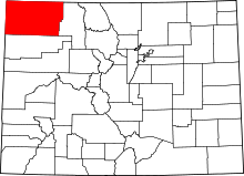
 Location in Moffat County and Colorado | |
| Coordinates: 40°14′26″N 109°00′31″W / 40.240551°N 109.008590°WCoordinates: 40°14′26″N 109°00′31″W / 40.240551°N 109.008590°W[1] | |
| Country |
|
| State |
|
| County | Moffat County[2] |
| Incorporated | 1947-12-09, as the Town of Artesia[3] |
| Government | |
| • Type | Statutory Town[2] |
| Area | |
| • Total | 0.8 sq mi (2.0 km2) |
| • Land | 0.8 sq mi (2.0 km2) |
| • Water | 0 sq mi (0 km2) |
| Elevation[4] | 5,922 ft (1,805 m) |
| Population (2015) | |
| • Total | 311 |
| Time zone | MST (UTC-7) |
| • Summer (DST) | MDT (UTC-6) |
| ZIP codes[5] | 81610 & 81633 |
| Area code(s) | 970 |
| INCITS place code | 0820495 |
| GNIS feature ID | 0171542 |
Dinosaur is a Statutory Town located in Moffat County, Colorado, United States. The town population was 339 at the 2010 census.[6]
Dinosaur has been noted for its unusual place name.[7] The town of Dinosaur was originally named Artesia; the current name was adopted in 1966, to capitalize on the town's proximity to Dinosaur National Monument.[8] The monument headquarters is located just east of the town on U.S. Highway 40.
Geography
| Historical population | ||
|---|---|---|
| Year | Pop. | ±% |
| 1950 | 281 | — |
| 1960 | 318 | +13.2% |
| 1970 | 247 | −22.3% |
| 1980 | 313 | +26.7% |
| 1990 | 324 | +3.5% |
| 2000 | 314 | −3.1% |
| 2001 | 313 | −0.3% |
| 2002 | 318 | +1.6% |
| 2003 | 317 | −0.3% |
| 2004 | 320 | +0.9% |
| 2005 | 315 | −1.6% |
| 2006 | 320 | +1.6% |
| 2007 | 326 | +1.9% |
| 2008 | 333 | +2.1% |
| 2009 | 337 | +1.2% |
| 2010 | 339 | +0.6% |
| 2011 | 329 | −2.9% |
| 2012 | 321 | −2.4% |
| 2013 | 318 | −0.9% |
| 2014 | 312 | −1.9% |
| 2015 | 311 | −0.3% |
Source: | ||
Dinosaur is located at 40°14′30″N 109°0′31″W / 40.24167°N 109.00861°W (40.241560, -109.008747).[12]
According to the United States Census Bureau, the town has a total area of 0.77 square miles (2.0 km2), all of it land.[6]
Many streets in the town are named after dinosaurs, including Cletisaurus Circle, Tyrannosaurus Trail, and Antrodemus Alley.[13]
Demographics
As of the census[14] of 2000, there were 320 people, 124 households, and 88 families residing in the town. The population density was 400.9 people per square mile (154.0/km²). There were 156 housing units at an average density of 196.1 per square mile (75.3/km²). The racial makeup of the town was 98.43% White, 0.31% from other races, and 1.25% from two or more races. Hispanic or Latino of any race were 3.76% of the population.
There were 124 households out of which 34.7% had children under the age of 18 living with them, 57.3% were married couples living together, 9.7% had a female householder with no husband present, and 29.0% were non-families. 25.0% of all households were made up of individuals and 12.9% had someone living alone who was 65 years of age or older. The average household size was 2.57 and the average family size was 3.10.
In the town the population was spread out with 28.5% under the age of 18, 9.4% from 18 to 24, 26.6% from 25 to 44, 23.5% from 45 to 64, and 11.9% who were 65 years of age or older. The median age was 36 years. For every 100 females there were 96.9 males. For every 100 females age 18 and over, there were 94.9 males.
The median income for a household in the town was $31,250, and the median income for a family was $31,250. Males had a median income of $43,500 versus $16,250 for females. The per capita income for the town was $12,904. About 18.8% of families and 17.9% of the population were below the poverty line, including 15.6% of those under age 18 and 14.3% of those age 65 or over.
Historic places
Near Dinosaur are the following sites listed in the National Register of Historic Places:[15]
- Castle Park Archeological District, a prehistoric residential site with inhabitation during 1500 - 1000 BC and again from AD 1000 - 1899 by the Prehistoric Fremont culture, Ute and Shoshone people
- Mantle's Cave, a prehistoric Fremont culture residential site from 499 BC - AD 1749
- Historic sites in the Dinosaur National Monument
- Denis Julien Inscription
- Rial Chew Ranch Complex
- Upper Wade and Curtis Cabin
-

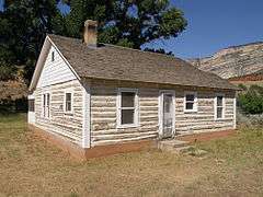
Rial Chew Ranch Complex cabin
-

Rial Chew Ranch Complex garage

In popular culture
In the October 2009 issue of Dark Avengers by Marvel Comics, Dinosaur is the site of a portal that consumes Norman Osborn's Dark Avengers.
In addition, Dinosaur is also the hometown of the Marvel Comics villain, Molecule Man.
See also
References
- ↑ "2014 U.S. Gazetteer Files: Places". United States Census Bureau. July 1, 2014. Retrieved January 5, 2015.
- 1 2 "Active Colorado Municipalities". State of Colorado, Department of Local Affairs. Retrieved 2007-09-01.
- ↑ "Colorado Municipal Incorporations". State of Colorado, Department of Personnel & Administration, Colorado State Archives. 2004-12-01. Retrieved 2007-09-02.
- ↑ "US Board on Geographic Names". United States Geological Survey. 2007-10-25. Retrieved 2008-01-31.
- ↑ "ZIP Code Lookup" (JavaScript/HTML). United States Postal Service. Retrieved September 8, 2007.
- 1 2 "Geographic Identifiers: 2010 Demographic Profile Data (G001): Dinosaur town, Colorado". U.S. Census Bureau, American Factfinder. Retrieved January 31, 2013.
- ↑ Thompson, George E. (1 July 2009). You Live Where?: Interesting and Unusual Facts about where We Live. iUniverse. p. 13. ISBN 978-1-4401-3421-0.
- ↑ "Dinosaur". Colorado Tourism Office. 2010. Retrieved 2010-05-30.
- 1 2 "Census of Population and Housing". Census.gov. Retrieved June 4, 2015.
- ↑ http://www.census.gov/popest/data/intercensal/cities/cities2010.html
- ↑ "Annual Estimates of the Resident Population for Incorporated Places: April 1, 2010 to July 1, 2015".
- ↑ "US Gazetteer files: 2010, 2000, and 1990". United States Census Bureau. 2011-02-12. Retrieved 2011-04-23.
- ↑ "Key to the City: Dinosaur". usacitiesonline.com. Retrieved 2010-05-30.
- ↑ "American FactFinder". United States Census Bureau. Retrieved 2008-01-31.
- ↑ National Register of Historic Places in Moffat County American Dreams, Inc. Retrieved 2011-10-6.
