Dissay
| Dissay | ||
|---|---|---|
|
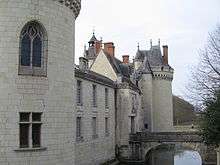
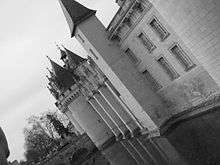
Castle of Dissay | ||
| ||
 Dissay | ||
|
Location within Nouvelle-Aquitaine region  Dissay | ||
| Coordinates: 46°42′06″N 0°25′57″E / 46.7017°N 0.4325°ECoordinates: 46°42′06″N 0°25′57″E / 46.7017°N 0.4325°E | ||
| Country | France | |
| Region | Nouvelle-Aquitaine | |
| Department | Vienne | |
| Arrondissement | Poitiers | |
| Canton | Saint-Georges-lès-Baillargeaux | |
| Intercommunality | Val Vert du Clain | |
| Government | ||
| • Mayor (2008–2014) | Louis Remblier | |
| Area1 | 23.71 km2 (9.15 sq mi) | |
| Population (2007)2 | 2,912 | |
| • Density | 120/km2 (320/sq mi) | |
| Time zone | CET (UTC+1) | |
| • Summer (DST) | CEST (UTC+2) | |
| INSEE/Postal code | 86095 / 86130 | |
| Elevation |
60–144 m (197–472 ft) (avg. 64 m or 210 ft) | |
|
1 French Land Register data, which excludes lakes, ponds, glaciers > 1 km² (0.386 sq mi or 247 acres) and river estuaries. 2 Population without double counting: residents of multiple communes (e.g., students and military personnel) only counted once. | ||
.jpg)
Dissay is a commune in the Vienne department in the Nouvelle-Aquitaine region in western France.

The main landmark is the castle, built in the 15th century by Pierre d'Amboise, bishop of Poitiers.
History
Human settlement in the territory of Dissay dates back millennia: a single grave in Poitou-Charentes dates back to 4300 BC. Gallo-Roman houses spring up along the Roman road that links Saintes to Poitiers Tours. The territory of Dissay is arranged like an axis, with this road as one of the lines. Tradition maintains the "Roman road" as a recurring term for that road.
Economy
Dissay has a geographic location on the Poitiers-Chatellerault axis. Its labor force is of 1506 active workers (activity rate: 78.2%). More than 80 merchants, artisans, industries and services are currently located in the town center and the two parks of the town.
Twin towns
 Madone, Italy
See also
References
| Wikimedia Commons has media related to Dissay. |