Lusignan, Vienne
| Lusignan | ||
|---|---|---|
|
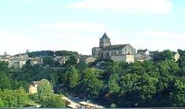
A general view of Lusignan | ||
| ||
 Lusignan | ||
|
Location within Nouvelle-Aquitaine region  Lusignan | ||
| Coordinates: 46°26′08″N 0°07′25″E / 46.4356°N 0.1236°ECoordinates: 46°26′08″N 0°07′25″E / 46.4356°N 0.1236°E | ||
| Country | France | |
| Region | Nouvelle-Aquitaine | |
| Department | Vienne | |
| Arrondissement | Poitiers | |
| Canton | Lusignan | |
| Intercommunality | Pays Mélusin | |
| Government | ||
| • Mayor (2001–2008) | René Gibault | |
| Area1 | 37.82 km2 (14.60 sq mi) | |
| Population (2006)2 | 2,622 | |
| • Density | 69/km2 (180/sq mi) | |
| Time zone | CET (UTC+1) | |
| • Summer (DST) | CEST (UTC+2) | |
| INSEE/Postal code | 86139 / 86600 | |
| Elevation |
99–159 m (325–522 ft) (avg. 132 m or 433 ft) | |
|
1 French Land Register data, which excludes lakes, ponds, glaciers > 1 km² (0.386 sq mi or 247 acres) and river estuaries. 2 Population without double counting: residents of multiple communes (e.g., students and military personnel) only counted once. | ||
Lusignan is a commune in the Vienne department in the Nouvelle-Aquitaine region in western France. It lies 25 km southwest of Poitiers. The inhabitants are called Mélusins and Mélusines.
Geography
The town of Lusignan now has about 3,000 inhabitants. It is located on the road RN11 from Poitiers to La Rochelle. It is about 400 km from Paris.
River: La Vonne
Monuments
- Château de Lusignan - The largest castle of France.
Personalities
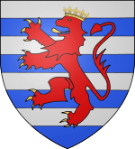
- House of Lusignan
- Guy de Lusignan. Connétable de Chypre (? - † 1302)
- Jacques Babinet, scientist.
- André Léo, (1824–1900), real name Léodile Béra, female writer.
Gallery
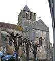 The church
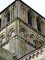 The Church (detail)
See also
References
External links
| Wikimedia Commons has media related to Lusignan, Vienne. |
This article is issued from Wikipedia - version of the 11/11/2016. The text is available under the Creative Commons Attribution/Share Alike but additional terms may apply for the media files.