Château-Larcher
| Château-Larcher | |
|---|---|
|
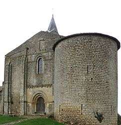
The church in Château-Larcher | |
 Château-Larcher | |
|
Location within Nouvelle-Aquitaine region  Château-Larcher | |
| Coordinates: 46°25′06″N 0°18′55″E / 46.4183°N 0.3153°ECoordinates: 46°25′06″N 0°18′55″E / 46.4183°N 0.3153°E | |
| Country | France |
| Region | Nouvelle-Aquitaine |
| Department | Vienne |
| Arrondissement | Poitiers |
| Canton | Vivonne |
| Intercommunality | Vonne et Clain |
| Government | |
| • Mayor (2008–2014) | Francis Gargouil |
| Area1 | 15.35 km2 (5.93 sq mi) |
| Population (2006)2 | 933 |
| • Density | 61/km2 (160/sq mi) |
| Time zone | CET (UTC+1) |
| • Summer (DST) | CEST (UTC+2) |
| INSEE/Postal code | 86065 / 86370 |
| Elevation |
85–135 m (279–443 ft) (avg. 95 m or 312 ft) |
|
1 French Land Register data, which excludes lakes, ponds, glaciers > 1 km² (0.386 sq mi or 247 acres) and river estuaries. 2 Population without double counting: residents of multiple communes (e.g., students and military personnel) only counted once. | |
Château-Larcher is a commune in the Vienne department in the Nouvelle-Aquitaine region in western France.
Geography
The Clouère flows northwesthward through the middle of the commune, forms part of its north-eastern border, then flows into the Clain, which forms its north-western border.
See also
References
| Wikimedia Commons has media related to Château-Larcher. |
This article is issued from Wikipedia - version of the 11/11/2016. The text is available under the Creative Commons Attribution/Share Alike but additional terms may apply for the media files.