Saint-Savin, Vienne
| Saint-Savin | ||
|---|---|---|
|
| ||
| ||
 Saint-Savin | ||
|
Location within Nouvelle-Aquitaine region  Saint-Savin | ||
| Coordinates: 46°34′01″N 0°51′52″E / 46.5669°N 0.8644°ECoordinates: 46°34′01″N 0°51′52″E / 46.5669°N 0.8644°E | ||
| Country | France | |
| Region | Nouvelle-Aquitaine | |
| Department | Vienne | |
| Arrondissement | Montmorillon | |
| Canton | Saint-Savin | |
| Intercommunality | Montmorillonnais | |
| Government | ||
| • Mayor (2001–2008) | Michel Brouard | |
| Area1 | 18.8 km2 (7.3 sq mi) | |
| Population (2006)2 | 957 | |
| • Density | 51/km2 (130/sq mi) | |
| Time zone | CET (UTC+1) | |
| • Summer (DST) | CEST (UTC+2) | |
| INSEE/Postal code | 86246 / 86310 | |
| Elevation |
72–142 m (236–466 ft) (avg. 80 m or 260 ft) | |
|
1 French Land Register data, which excludes lakes, ponds, glaciers > 1 km² (0.386 sq mi or 247 acres) and river estuaries. 2 Population without double counting: residents of multiple communes (e.g., students and military personnel) only counted once. | ||
.svg.png)
Saint-Savin, also referred to as Saint-Savin sur Gartempe ((pronounced: [sɛ̃ savɛ̃ syʁ ɡaʁtɑ̃p])), is a commune in the Vienne department in the Nouvelle-Aquitaine region in western France.
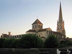
Abbey Church
Main article: Abbey Church of Saint-Savin-sur-Gartempe
The Romanesque Abbey Church, begun in the mid 11th century, contains many beautiful 11th- and 12th-century murals which are still in a remarkable state of preservation. It has been a UNESCO World Heritage Site since 1983.
Demographics
| Year | 1962 | 1968 | 1975 | 1982 | 1990 | 1999 | 2006 |
|---|---|---|---|---|---|---|---|
| Population | 1283 | 1349 | 1323 | 1058 | 1089 | 1009 | 957 |
See also
References
External links
- Saint-Savin-sur-Gartempe (French)
| Wikimedia Commons has media related to Saint-Savin-sur-Gartempe. |
This article is issued from Wikipedia - version of the 11/11/2016. The text is available under the Creative Commons Attribution/Share Alike but additional terms may apply for the media files.