Dunbar (CDP), Wisconsin
| Dunbar, Wisconsin | |
|---|---|
| Census-designated place | |
|
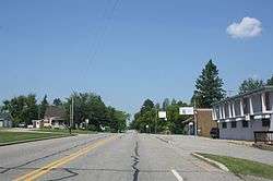
Looking west in downtown Dunbar on US8 | |
 Dunbar, Wisconsin | |
| Coordinates: 45°39′03″N 88°10′17″W / 45.65083°N 88.17139°WCoordinates: 45°39′03″N 88°10′17″W / 45.65083°N 88.17139°W | |
| Country | United States |
| State | Wisconsin |
| County | Marinette |
| Area | |
| • Total | 1.066 sq mi (2.76 km2) |
| • Land | 1.064 sq mi (2.76 km2) |
| • Water | 0.002 sq mi (0.005 km2) |
| Elevation | 1,306 ft (398 m) |
| Population (2010) | |
| • Total | 50 |
| • Density | 47/sq mi (18/km2) |
| Time zone | Central (CST) (UTC-6) |
| • Summer (DST) | CDT (UTC-5) |
| ZIP code | 54119 |
| Area code(s) | 715 & 534 |
| GNIS feature ID | 1564171[1] |
Dunbar is an unincorporated census-designated place located in the town of Dunbar, Marinette County, Wisconsin, United States. Dunbar is located on U.S. Route 8 12 miles (19 km) southwest of Niagara. Dunbar has a post office with ZIP code 54119.[2] As of the 2010 census, its population is 50.[3]
Images
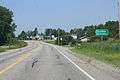 Sign on US8
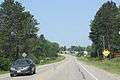 Panorama
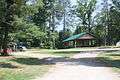 Veteran's Park
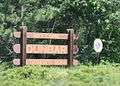 Welcome sign
References
| Wikimedia Commons has media related to Dunbar, Wisconsin. |
Municipalities and communities of Marinette County, Wisconsin, United States | ||
|---|---|---|
| Cities | 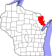 | |
| Villages | ||
| Towns | ||
| CDPs | ||
| Unincorporated communities | ||
| Footnotes | ‡This populated place also has portions in an adjacent county or counties | |
This article is issued from Wikipedia - version of the 9/4/2016. The text is available under the Creative Commons Attribution/Share Alike but additional terms may apply for the media files.