Eagle Point, Oregon
| Eagle Point, Oregon | |
|---|---|
| City | |
|
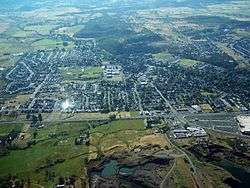
An aerial image of Eagle Point | |
| Nickname(s): Gateway to the Lakes | |
 Location in Oregon | |
| Coordinates: 42°28′4″N 122°48′6″W / 42.46778°N 122.80167°WCoordinates: 42°28′4″N 122°48′6″W / 42.46778°N 122.80167°W | |
| Country | United States |
| State | Oregon |
| County | Jackson |
| Incorporated | 1911 |
| Government | |
| • Mayor | Bob Russell[1] |
| Area[2] | |
| • Total | 2.96 sq mi (7.67 km2) |
| • Land | 2.96 sq mi (7.67 km2) |
| • Water | 0 sq mi (0 km2) |
| Elevation | 1,310 ft (399.3 m) |
| Population (2010)[3] | |
| • Total | 8,469 |
| • Estimate (2012[4]) | 8,624 |
| • Density | 2,861.1/sq mi (1,104.7/km2) |
| Time zone | Pacific (UTC-8) |
| • Summer (DST) | Pacific (UTC-7) |
| ZIP code | 97524 |
| Area code(s) | 541 |
| FIPS code | 41-21550[3] |
| GNIS feature ID | 1161353[5] |
| Website | www.cityofeaglepoint.org |
Eagle Point is a city in Jackson County, Oregon, United States. The population was estimated at 8,624 as of 2012.[4]
History
In the mid-19th century, a rocky cliff near the location of what later became Eagle Point was a favored nesting place for eagles. An area resident, John Mathews, is said to have suggested the name Eagle Point as the name for a proposed post office in the community. The post office was established in 1872; Andrew McNeil was the first postmaster.[6]
A water-powered gristmill, Butte Creek Mill, has operated in Eagle Point for more than 125 years. Built in 1872 along Little Butte Creek, it was added to the National Register of Historic Places in 1976.[6] The mill burned to the ground Christmas Day 2015, however will be rebuilt.
Geography
According to the United States Census Bureau, the city has a total area of 2.96 square miles (7.67 km2), all of it land.[2]
The city is north of Medford and White City and south of Shady Cove in the Rogue River Valley along Oregon Route 62. Little Butte Creek, a tributary of the Rogue River, passes through Eagle Point and enters the larger stream a few miles to the west near TouVelle State Recreation Site and Upper and Lower Table Rock.[7]
Climate
This region experiences warm (but not hot) and dry summers, with no average monthly temperatures above 71.6 °F (22.0 °C). According to the Köppen Climate Classification system, Eagle Point has a warm-summer Mediterranean climate, abbreviated "Csb" on climate maps.[8]
Demographics
| Historical population | |||
|---|---|---|---|
| Census | Pop. | %± | |
| 1920 | 128 | — | |
| 1930 | 211 | 64.8% | |
| 1940 | 243 | 15.2% | |
| 1950 | 607 | 149.8% | |
| 1960 | 752 | 23.9% | |
| 1970 | 1,241 | 65.0% | |
| 1980 | 2,764 | 122.7% | |
| 1990 | 3,008 | 8.8% | |
| 2000 | 4,798 | 59.5% | |
| 2010 | 8,469 | 76.5% | |
| Est. 2015 | 8,902 | [9] | 5.1% |
2010 census
As of the census of 2010, there were 8,469 people, 3,231 households, and 2,373 families residing in the city. The population density was 2,861.1 inhabitants per square mile (1,104.7/km2). There were 3,611 housing units at an average density of 1,219.9 per square mile (471.0/km2). The racial makeup of the city was 92.1% White, 0.2% African American, 1.3% Native American, 1.0% Asian, 0.1% Pacific Islander, 1.7% from other races, and 3.6% from two or more races. Hispanic or Latino of any race were 6.8% of the population.[3]
There were 3,231 households of which 37.5% had children under the age of 18 living with them, 55.9% were married couples living together, 12.0% had a female householder with no husband present, 5.5% had a male householder with no wife present, and 26.6% were non-families. 20.9% of all households were made up of individuals and 9.7% had someone living alone who was 65 years of age or older. The average household size was 2.62 and the average family size was 3.01.[3]
The median age in the city was 36.9 years. 27.3% of residents were under the age of 18; 6.7% were between the ages of 18 and 24; 26.2% were from 25 to 44; 25.5% were from 45 to 64; and 14.2% were 65 years of age or older. The gender makeup of the city was 48.1% male and 51.9% female.[3]
2000 census
As of the census of 2000, there were 4,797 people, 1,703 households, and 1,313 families residing in the city. The population density was 1,869.9 people per square mile (720.7/km²). There were 1,823 housing units at an average density of 710.6 per square mile (273.9/km²). The racial makeup of the city was 93.16% White, 0.38% African American, 1.73% Native American, 0.40% Asian, 0.19% Pacific Islander, 1.10% from other races, and 3.04% from two or more races. Hispanic or Latino of any race were 3.52% of the population.[3]
There were 1,703 households out of which 45.6% had children under the age of 18 living with them, 56.9% were married couples living together, 14.6% had a female householder with no husband present, and 22.9% were non-families. 18.1% of all households were made up of individuals and 8.1% had someone living alone who was 65 years of age or older. The average household size was 2.82 and the average family size was 3.17. In the city the population was 32.6% under the age of 18, 9.4% from 18 to 24, 29.2% from 25 to 44, 19.7% from 45 to 64, and 9.1% who were 65 years of age or older. The median age was 30 years. For every 100 females there were 93.2 males. For every 100 females age 18 and over, there were 89.7 males. The median income for a household in the city was $37,557, and the median income for a family was $40,598. Males had a median income of $30,795 versus $20,956 for females. The per capita income for the city was $15,501. About 11.4% of families and 12.8% of the population were below the poverty line, including 18.7% of those under age 18 and 15.1% of those age 65 or over.[3]
Notable people
- Jim Belushi, television actor, comedian and singer, starred on Saturday Night Live and According To Jim
- Patrick Duffy, television actor, starred in Dallas[11]
- Kim Novak, actress, starred in Vertigo[12] and Picnic
See also
- Denman Wildlife Area, near Eagle Point
- Eagle Point National Cemetery
References
- ↑ "EP seats council, selects new member". Upper Rogue Independent. January 18, 2011. Retrieved 2011-05-27.
- 1 2 "US Gazetteer files 2010". United States Census Bureau. Retrieved 2012-12-21.
- 1 2 3 4 5 6 7 "American FactFinder". United States Census Bureau. Retrieved 2012-12-21.
- 1 2 "Population Estimates". United States Census Bureau. Retrieved 2013-06-02.
- ↑ "US Board on Geographic Names". United States Geological Survey. 2007-10-25. Retrieved 2008-01-31.
- 1 2 McArthur, Lewis A.; Lewis L. McArthur (2003) [1928]. Oregon Geographic Names (7th ed.). Portland, Oregon: Oregon Historical Society Press. p. 312. ISBN 0-87595-277-1.
- ↑ Oregon Road & Recreation Atlas (5th ed.). Santa Barbara, California: Benchmark Maps. 2012. p. 96. ISBN 978-0-929591-62-9.
- ↑ "Eagle Point, Oregon". Weatherbase. CantyMedia. Retrieved October 13, 2015.
- ↑ "Annual Estimates of the Resident Population for Incorporated Places: April 1, 2010 to July 1, 2015". Retrieved July 2, 2016.
- ↑ "Census of Population and Housing". Census.gov. Retrieved June 4, 2015.
- ↑ Patrick Duffy Biography Channel bio
- ↑ Kim Novak Mail Tribune
External links
Municipalities and communities of Jackson County, Oregon, United States | ||
|---|---|---|
| Cities | 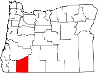 | |
| CDPs | ||
| Other unincorporated communities | ||
| Ghost towns | ||