Trail, Oregon
| Trail | |
|---|---|
| Unincorporated community & census-designated place | |
|
An aerial image of Trail and the Rogue River | |
 Trail  Trail Location within the state of Oregon | |
| Coordinates: 42°38′54″N 122°48′38″W / 42.64833°N 122.81056°WCoordinates: 42°38′54″N 122°48′38″W / 42.64833°N 122.81056°W | |
| Country | United States |
| State | Oregon |
| County | Jackson |
| Elevation[1] | 1,430 ft (440 m) |
| Time zone | Pacific (PST) (UTC-8) |
| • Summer (DST) | PDT (UTC-7) |
| ZIP codes | 97541 |
| GNIS feature ID | 1151362 |
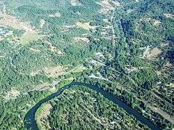
Trail is a census-designated place and unincorporated community in Jackson County, Oregon, United States. Although it is unincorporated, it has a post office with a ZIP code of 97541.[1][2] Trail lies at the intersection of Oregon Route 227 and Oregon Route 62, just north of Shady Cove and west of Lost Creek Lake, which is a reservoir of the Rogue River. Trail is located around the mouth of Trail Creek at the Rogue River.[3]
Climate
This region experiences warm (but not hot) and dry summers, with no average monthly temperatures above 71.6 °F. According to the Köppen Climate Classification system, Trail has a warm-summer Mediterranean climate, abbreviated "Csb" on climate maps.[4]
References
- 1 2 "Trail". Geographic Names Information System. United States Geological Survey. November 28, 1980. Retrieved December 8, 2013.
- ↑ Zip Code Lookup
- ↑ "Trail, OR". Google Maps. Retrieved December 8, 2013.
- ↑ Climate Summary for Trail, Oregon
Municipalities and communities of Jackson County, Oregon, United States | ||
|---|---|---|
| Cities | 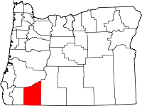 | |
| CDPs | ||
| Other unincorporated communities | ||
| Ghost towns | ||
This article is issued from Wikipedia - version of the 7/30/2016. The text is available under the Creative Commons Attribution/Share Alike but additional terms may apply for the media files.