Ereğli, Konya
| Ereğli | |
|---|---|
| District | |
 Location of Ereğli, Konya within Turkey. | |
 Ereğli Location of Ereğli, Konya within Turkey. | |
| Coordinates: 37°31′N 34°03′E / 37.517°N 34.050°ECoordinates: 37°31′N 34°03′E / 37.517°N 34.050°E | |
| Country |
|
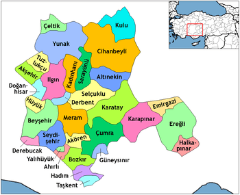
| Province | Konya |
| Government | |
| • Mayor | Özkan Özgüven(AKP) |
| Area[1] | |
| • District | 2,560.32 km2 (988.55 sq mi) |
| Elevation | 1,043 m (3,422 ft) |
| Population (2012)[2] | |
| • Urban | 98,663 |
| • District | Template:Turkey district obpopulations |
| Time zone | EET (UTC+2) |
| • Summer (DST) | EEST (UTC+3) |
| Postal code | 42xxx |
| Area code(s) | 0332 |
| Licence plate | 42 |
| Website | www.konya-eregli.gov.tr |
Ereğli is a town and district of Konya Province in the Central Anatolia region of Turkey. According to 2009 census, the population of the district is 135,008 of which 95,056 live in the town of Ereğli.[3][4][5]
History

Heraclea Cybistra under the name Cybistra (Ηράκλεια Κυβίστρα in Ancient greek), had some importance in Hellenistic times owing to its position near the point where the road to the Gülek Pass (Cilician Gates) enters the hills. It lay in the way of armies and was more than once sacked by the Arab invaders of Asia Minor (AD 805 and 832). During the Crusade of 1101 it was the scene of a failed battle of 15,000 men led by William II, Count of Nevers, which left the Crusaders weak en route to Antioch.[6] It became Turkish (Seljuk) in the 11th century. Ereğli is also known for being the first capital of the Karaman Beylik founded by Nure Sufi Bey. The Karaman state was renowned for being a consistent nuisance to Ottoman dominance in Anatolia, being one of the few Anatolian beyliks to retain sovereignty well past Fatih Sultan Mehmet's conquest of Istanbul. It was also the first political entity in Anatolia to proclaim Turkish as an official language. In 1553, upon return from a campaign in Persia, Suleiman the Magnificent had his son, Şehzade Mustafa, killed in the Ereğli valley where the Ottoman army was stationed. Modern Ereğli had grown from a large village to a town since the railway reached it from Konya and Karaman in 1904; and it has now hotels and thriving businesses. Three hours’ ride south is the famous "Hittite" rock relief of a lynx, representing a king (probably of neighbouring Tyana) adoring a god. This was the first "Hittite" monument discovered in modern times (early 18th century, by the Swede Otter, an emissary of Louis XIV).
Transportation
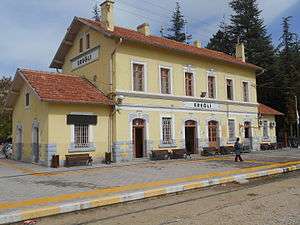
Ereğli Gar is the railway station of the town. Once served by several train lines that have destinations to Istanbul, İzmir and Konya, the station is currently served by Mainline / Toros Ekspresi only, which connects Ereğli to Adana and Karaman.
Notable residents
- Nimet Çubukçu, current Minister of Education of Turkey.
- Ali Talip Özdemir, former head of the Motherland Party (ANAP)
- Şehzade Mustafa, heir to the Ottoman throne who was killed in the Ereğli valley
International relations
Twin towns — Sister cities
Ereğli is twinned with:
See also
- Kwangjin Park, a park in Ereğli.
Notes
- ↑ "Area of regions (including lakes), km²". Regional Statistics Database. Turkish Statistical Institute. 2002. Retrieved 2013-03-05.
- ↑ "Population of province/district centers and towns/villages by districts - 2012". Address Based Population Registration System (ABPRS) Database. Turkish Statistical Institute. Retrieved 2013-02-27.
- ↑
- ↑ Turkish Statistical Institute. "Census 2000, Key statistics for urban areas of Turkey" (XLS) (in Turkish). Retrieved 2008-03-25.
- ↑ GeoHive. "Statistical information on Turkey's administrative units". Retrieved 2008-03-25.
- ↑ Richard, Jean. The Crusades, C. 1071-c. 1291. Cambridge University Press. p. 73. ISBN 0-521-62566-1.
- ↑ "Twinnings" (PDF). Central Union of Municipalities & Communities of Greece. Retrieved 2013-08-25.
References
- Falling Rain Genomics, Inc. "Geographical information on Ereğli, Turkey". Retrieved 2008-03-25.
External links
| Wikimedia Commons has media related to Ereğli. |
- District governor's official website (Turkish)
- District Municipality's official website (Turkish)