Erto e Casso
| Erto e Casso | ||
|---|---|---|
| Comune | ||
| Comune di Erto e Casso | ||
|
View of a central road in Erto | ||
| ||
.svg.png) Erto e Casso within the Province of Pordenone | ||
 Erto e Casso Location of Erto e Casso in Italy | ||
| Coordinates: 46°16′37.31″N 12°22′19.13″E / 46.2770306°N 12.3719806°ECoordinates: 46°16′37.31″N 12°22′19.13″E / 46.2770306°N 12.3719806°E | ||
| Country | Italy | |
| Region | Friuli-Venezia Giulia | |
| Province / Metropolitan city | Pordenone (PN) | |
| Frazioni | Casso, Erto[1] | |
| Government | ||
| • Mayor | Luciano Giuseppe Pezzin | |
| Area | ||
| • Total | 52.3 km2 (20.2 sq mi) | |
| Elevation | 775 m (2,543 ft) | |
| Population (31 December 2008[2]) | ||
| • Total | 388 | |
| • Density | 7.4/km2 (19/sq mi) | |
| Demonym(s) | Ertani | |
| Time zone | CET (UTC+1) | |
| • Summer (DST) | CEST (UTC+2) | |
| Postal code | 33080 | |
| Dialing code | 0427 | |
| Website | Official website | |


Erto e Casso is an Italian municipality in the Province of Pordenone in the Italian region Friuli-Venezia Giulia, located about 130 kilometres (81 mi) northwest of Trieste and about 40 kilometres (25 mi) northwest of Pordenone.
Geography
The commune consists of Erto (the municipal seat, population: 341[3]), Casso (population: 35[4]), and some smaller places: Cavalle, Col della Ruava, Forcai, Liron, Pineda, San Martino and Val del Pont.
Erto e Casso borders the municipalities of Castellavazzo, Cimolais, Claut, Longarone, Ospitale di Cadore, Perarolo di Cadore, Pieve d'Alpago, and Soverzene. All the bordering municipalities, except Cimolais and Claut, are part of the nearby Province of Belluno, in Veneto.
The comune is composed by the main settlements of Erto, the administrative seat, and Casso. The other hamlets, (frazioni), composed by few scattered farmhouses, are the localities of Forcai, Pineda, San Martino, and Val da Pont.
History
Early history
The village of Erto was first mentioned in 8th century. Differently from Casso, in which is spoken bellunese (a Venetian dialect), the local language is a dialect of Ladin language, colloquailly named ertano.
Vajont disaster

Erto and Casso were the two villages in the Vajont (/vaˈjɔnt/) valley, above the artificial lake, before the Vajont Dam disaster on 9 October 1963. The landslide and flood killed almost 2,000 people in total, destroying five villages in the Piave valley but leaving Erto and Casso only slightly damaged. The two villages were cautionally evacuated within three days of the disaster and the valley stayed empty for three years thereafter. During those years, some of the survivors settled down in the Maniago municipality, creating what would become the new Vajont municipality from 1971.
Three years after evacuation, some other survivors, in spite of being forbidden to return to the valley, went back to their former houses and reformed the villages of Erto and Casso, which still form the municipality today.[5]
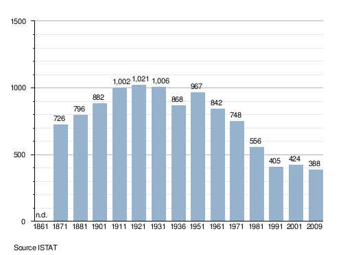
Demographics
Personalities
- Mauro Corona (b. 1950), writer[6]
See also
References
- ↑ Municipal seat
- ↑ All demographics and other statistics: Italian statistical institute Istat.
- ↑ (Italian) Infos about Erto on italia.indettaglio.it
- ↑ (Italian) Infos about Casso on italia.indettaglio.it
- ↑ (Italian) Information about the Vajont disaster on municipal website
- ↑ (Italian) Infos about Mauro Corona on municipal website
External links
| Wikimedia Commons has media related to Erto e Casso. |
- (Italian) Erto village website
- (Italian) Erto e Casso official website
- (Italian) Mountain Community of Western Friuli