Sesto al Reghena
| Sesto al Reghena | ||
|---|---|---|
| Comune | ||
| Comune di Sesto al Reghena | ||
|
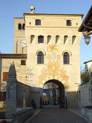
The main gate of the abbey of Santa Maria in Sylvis. | ||
| ||
 Sesto al Reghena Location of Sesto al Reghena in Italy | ||
| Coordinates: 45°51′N 12°49′E / 45.850°N 12.817°E | ||
| Country | Italy | |
| Region | Friuli-Venezia Giulia | |
| Province / Metropolitan city | Pordenone (PN) | |
| Frazioni | Bagnarola, Ramuscello, Marignana | |
| Government | ||
| • Mayor | Ivo Chiarot | |
| Area | ||
| • Total | 40.5 km2 (15.6 sq mi) | |
| Elevation | 13 m (43 ft) | |
| Population (31 December 2012)[1] | ||
| • Total | 6,393 | |
| • Density | 160/km2 (410/sq mi) | |
| Time zone | CET (UTC+1) | |
| • Summer (DST) | CEST (UTC+2) | |
| Postal code | 33079-33071-33070-33073 | |
| Dialing code | 0434 | |
| Website | Official website | |
Sesto al Reghena (Friulian: Siest) is a comune (municipality) in the Province of Pordenone in the Italian region Friuli-Venezia Giulia, located in the lower Friulian-Venetian plain about 80 kilometres (50 mi) northwest of Trieste and about 20 kilometres (12 mi) southeast of Pordenone.
Sesto al Reghena borders the following municipalities: Chions, Cinto Caomaggiore, Cordovado, Gruaro, Morsano al Tagliamento, San Vito al Tagliamento.
Main sights
Sights include the abbey of Santa Maria in Sylvis, a Benedictine monastery built in the 8th century.
References
External links
This article is issued from Wikipedia - version of the 5/31/2015. The text is available under the Creative Commons Attribution/Share Alike but additional terms may apply for the media files.