Fallon, Oklahoma
| Fallon, Oklahoma | |
|---|---|
| Unincorporated community | |
 Fallon  Fallon Location within the state of Oklahoma | |
| Coordinates: 33°59′52″N 95°25′01″W / 33.99778°N 95.41694°WCoordinates: 33°59′52″N 95°25′01″W / 33.99778°N 95.41694°W | |
| Country | United States |
| State | Oklahoma |
| County | Choctaw |
| Time zone | Central (CST) (UTC-6) |
| • Summer (DST) | CDT (UTC-5) |
| GNIS feature ID | 1100404 |
Fallon is an unincorporated community in Choctaw County, Oklahoma, along U.S. Route 70.[1][2]
References
- ↑ Official State Highway Map (Map) (2005-2006 ed.). Oklahoma Department of Transportation. § O7.
- ↑ U.S. Geological Survey Geographic Names Information System: Fallon, Oklahoma
Municipalities and communities of Choctaw County, Oklahoma, United States | ||
|---|---|---|
| City | 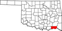 | |
| Towns | ||
| CDPs | ||
| Other unincorporated communities | ||
This article is issued from Wikipedia - version of the 7/31/2016. The text is available under the Creative Commons Attribution/Share Alike but additional terms may apply for the media files.