Boswell, Oklahoma
| Boswell, Oklahoma | |
|---|---|
| Town | |
 Location of Boswell, Oklahoma | |
| Coordinates: 34°1′42″N 95°52′12″W / 34.02833°N 95.87000°WCoordinates: 34°1′42″N 95°52′12″W / 34.02833°N 95.87000°W | |
| Country | United States |
| State | Oklahoma |
| County | Choctaw |
| Area | |
| • Total | 0.7 sq mi (1.8 km2) |
| • Land | 0.7 sq mi (1.8 km2) |
| • Water | 0.0 sq mi (0.0 km2) |
| Elevation | 610 ft (186 m) |
| Population (2010) | |
| • Total | 709 |
| • Density | 1,013/sq mi (394/km2) |
| Time zone | Central (CST) (UTC-6) |
| • Summer (DST) | CDT (UTC-5) |
| ZIP code | 74727 |
| Area code(s) | 580 |
| FIPS code | 40-07750[1] |
| GNIS feature ID | 1090411[2] |
Boswell is a town in Choctaw County, Oklahoma, United States. The population was 709 at the 2010 census.[3]
One of the Choctaw Nation's first and most prominent settlements, Mayhew, Indian Territory, was located three miles north of present-day Boswell. The town was named for S.C. Boswell, a local merchant.
History
The Boswell area was one of the Choctaw Nation's first and most important settlements. A Presbyterian missionary station was founded at Mayhew, Indian Territory, three miles north of present-day Boswell in the 1840s. It soon became a government center as well as seat of civilization. Mayhew became the administrative and judicial capital of the Pushmataha District, one of three administrative super-regions comprising the Choctaw Nation.[4]
A United States Post Office was established at Mayhew, Indian Territory on February 5, 1845 and operated until September 30, 1902. It then moved two miles south to Boswell, which was then a new townsite along the new railroad, and changed its name to Boswell.
Boswell was named for S.C. Boswell, a local merchant.[5]
Geography
According to the United States Census Bureau, Boswell has a total area of 0.7 square miles (1.8 km2), of which, 0.7 square miles (1.8 km2) of it is land and 1.43% is water.
The town contains, Boswell State Park, an Oklahoma State Park largely occupied by a lake, which has been stocked with channel catfish.[6]
Climate
| Climate data for Boswell, Oklahoma | |||||||||||||
|---|---|---|---|---|---|---|---|---|---|---|---|---|---|
| Month | Jan | Feb | Mar | Apr | May | Jun | Jul | Aug | Sep | Oct | Nov | Dec | Year |
| Average high °F (°C) | 52.1 (11.2) |
57.0 (13.9) |
66.1 (18.9) |
74.0 (23.3) |
80.7 (27.1) |
88.2 (31.2) |
93.4 (34.1) |
93.5 (34.2) |
86.1 (30.1) |
76.4 (24.7) |
64.7 (18.2) |
55.2 (12.9) |
73.95 (23.32) |
| Average low °F (°C) | 28.7 (−1.8) |
33.4 (0.8) |
42.2 (5.7) |
51.5 (10.8) |
59.0 (15) |
66.6 (19.2) |
70.3 (21.3) |
69.1 (20.6) |
62.9 (17.2) |
51.2 (10.7) |
41.8 (5.4) |
32.4 (0.2) |
50.8 (10.4) |
| Average precipitation inches (mm) | 2.0 (51) |
3.1 (79) |
3.8 (97) |
3.9 (99) |
5.7 (145) |
4.1 (104) |
2.5 (64) |
2.5 (64) |
4.5 (114) |
4.2 (107) |
3.7 (94) |
2.8 (71) |
42.7 (1,085) |
| Source: Weatherbase.com [7] | |||||||||||||
Demographics
| Historical population | |||
|---|---|---|---|
| Census | Pop. | %± | |
| 1910 | 828 | — | |
| 1920 | 1,212 | 46.4% | |
| 1930 | 934 | −22.9% | |
| 1940 | 962 | 3.0% | |
| 1950 | 875 | −9.0% | |
| 1960 | 753 | −13.9% | |
| 1970 | 755 | 0.3% | |
| 1980 | 702 | −7.0% | |
| 1990 | 643 | −8.4% | |
| 2000 | 703 | 9.3% | |
| 2010 | 709 | 0.9% | |
| Est. 2015 | 699 | [8] | −1.4% |
As of the 2010 United States Census, there were 709 people, 295 households, and 184 families residing in the town.[10] The population density was 1,013 people per square mile (394/km²). There were 370 housing units at an average density of X per square mile (X/km²). The racial makeup of the town was 63.33% white, 18.05% Native American, 8.32% African American, 2.68% from other races, and 7.33% from two or more races.[3] Hispanic or Latino individuals were 5.92% of the population in 2010, having more than doubled since 2000.[3]
There were 295 households out of which 34.6% had children under the age of 18 living with them, 34.9% were married couples living together, 19.3% had a female householder with no husband present, and 37.6% were non-families. A third (34.6%) of households were made up of individuals and 15.3% had someone living alone who was 65 years of age or older. The average household size was 2.4 and the average family size was 3.04.[10]
In the town the population was spread out with 25.8% under the age of 18, 11.2% from 18 to 24, 21.3% from 25 to 44, 25.6% from 45 to 64, and 16.1% who were 65 years of age or older.[10] The median age was 36.6 years.[10] For every 100 females there were 87.6 males.[10] For every 100 females age 18 and over, there were X males.
The median income for a household in the town was $20,917, and the median income for a family was $27,300.[11] Males had a median income of $20,000 versus $17,292 for females. The per capita income for the town was $13,523. An estimated 35.8% of families and 39.2% of the population were below the poverty line, including 64.9% of those under age 18 and 14.4% of those age 65 or over.
In film
The Mobile Service Station scenes in the cult classic Two-Lane Blacktop (1971) were filmed in Boswell. Two-Lane Blacktop, starring singer-songwriter James Taylor, Warren Oates, Laurie Bird, and Dennis Wilson, is notable as a time capsule film of U.S. Route 66 during the pre-Interstate Highway era, and for its stark footage and minimal dialogue. As such it has become popular with fans of Route 66. Two-Lane Blacktop has been compared to similar road movies with an existentialist message from the era, such as Vanishing Point, Easy Rider, and Electra Glide in Blue.
References
- ↑ "American FactFinder". United States Census Bureau. Archived from the original on 2013-09-11. Retrieved 2008-01-31.
- ↑ "US Board on Geographic Names". United States Geological Survey. 2007-10-25. Retrieved 2008-01-31.
- 1 2 3 Census Viewer: Boswell, Oklahoma Population (accessed November 4, 2013)
- ↑ More information about Mayhew and its role in the Choctaw Nation political landscape is available in John Morris' Historical Atlas of Oklahoma and Angie Debo's Rise and Fall of the Choctaw Republic.
- ↑ George H. Shirk, Oklahoma Place Names, p. 27
- ↑ Outdoor Oklahoma (2005), Volumes 61-62, p. 234.
- ↑ "Historical Weather for Boswell, Oklahoma, United States".
- ↑ "Annual Estimates of the Resident Population for Incorporated Places: April 1, 2010 to July 1, 2015". Retrieved July 2, 2016.
- ↑ "Census of Population and Housing". Census.gov. Archived from the original on May 11, 2015. Retrieved June 4, 2015.
- 1 2 3 4 5 2010 Demographic Profile Data, American FactFinder Archived September 11, 2013, at the Wayback Machine.. (accessed November 4, 2013)
- ↑ 2007-2011 American Community Survey 5-Year Estimates, American FactFinder Archived September 11, 2013, at the Wayback Machine.. (accessed November 4, 2013)
External links
- Choctaw County: Official Website
- Two Lane Blacktop: Return to Boswell
- Encyclopedia of Oklahoma History and Culture - Boswell
Municipalities and communities of Choctaw County, Oklahoma, United States | ||
|---|---|---|
| City | 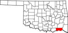 | |
| Towns | ||
| CDPs | ||
| Other unincorporated communities | ||