Fisherman's Island State Park
| Fisherman's Island State Park | |
|---|---|
 | |
 Location within the state of Michigan | |
| Location |
Norwood Township Charlevoix County, Michigan |
| Nearest city | Charlevoix, Michigan |
| Coordinates | 45°16′12″N 85°21′25″W / 45.27000°N 85.35694°WCoordinates: 45°16′12″N 85°21′25″W / 45.27000°N 85.35694°W |
| Area | 4.18 mi² (10.84 km²) |
| Governing body |
|
| Website | Official website |
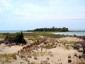
Fisherman's Island State Park is a 2,678-acre (10.84 km2) state park just south of Charlevoix, Michigan, with five miles (8 km) of the Lake Michigan shoreline. Steadily decreasing water levels have meant that the tiny island from which the park took its name has connected to the shore by a narrow strip of sand and thus become a peninsula.
The former island is located a short distance from the picnic area.[1] The park features a rustic campground with some of the sites nestled in the dunes along the lake shore. The park road travels through the campground to the picnic area with access to the beach and 3 miles of hiking trails. The interior terrain consists of rolling dunes covered with maple, birch and aspen broken up by bogs of cedar and black spruce. The park is opened from May 16 to November 16 and is maintained and operated by the Michigan Department of Natural Resources.
Facilities and activities
- Swimming
- Picnicking
- Hiking
- Camping: The camping area is divided into a north and south loop and has 81 sites and 6 vault toilets.
- Cross-country skiing
- Hunting
References
- ↑ "Fisherman's Island State Park". Retrieved 2011-09-26.
External links
- Fisherman's Island, Charlevoix, Michigan, USA
- Fisherman's Island State Park - Michigan DNR
- Map of Fisherman's Island State Park
- Protected Planet (World Database on Protected Areas) - Fisherman's Island State Park