Flodaigh, Lewis
For other places with the same name, see
Flodday.
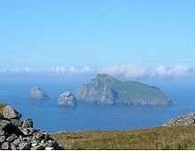
Flodaigh is a small island in Loch Roag on the west coast of Lewis in the Outer Hebrides of Scotland. It is about 33 hectares (82 acres) in extent and the highest point is 48 metres (157 ft). Its name derives from the Old Norse for "flat island".
Inland, the nearest settlement is opposite the hamlet of Cairisiadar. The island was last inhabited in 1827 when it was cleared to make way for a sheep farm.[3]
The small islet of Gousam lies to the north east and the larger islands of Fuaigh Beag and Fuaigh Mòr further east.
Notes
Coordinates: 58°11′37″N 6°55′46″W / 58.19361°N 6.92944°W / 58.19361; -6.92944
|
|---|
|
|
|
| Inhabited islands | | |
|---|
|
| Other islands | |
|---|
|
| Settlements | |
|---|
|
| Districts | |
|---|
|
| Geographical features | |
|---|
|
| Historical sites | |
|---|
|
|---|
|
| |
|
|
|
|
|
|
|
|
|
| Culture |
|---|
| | Shetland | |
|---|
| | Orkney | |
|---|
| | Outer Hebrides | |
|---|
| | Inner Hebrides | |
|---|
|
|
|
| Politics |
|---|
| | Local authorities | |
|---|
| | Serving MSPs | |
|---|
| | Serving MPs | |
|---|
| | Other | |
|---|
|
|
|
| Wildlife |
|---|
| | Fauna | |
|---|
| | Flora | |
|---|
| | Domesticated animals | |
|---|
|
|
|
|