Fond du Lac (town), Wisconsin
| Fond du Lac, Wisconsin | |
|---|---|
| Town | |
| Coordinates: 43°45′24″N 88°26′40″W / 43.75667°N 88.44444°WCoordinates: 43°45′24″N 88°26′40″W / 43.75667°N 88.44444°W | |
| Country | United States |
| State | Wisconsin |
| County | Fond du Lac |
| Area | |
| • Total | 20.9 sq mi (54.2 km2) |
| • Land | 19.9 sq mi (51.4 km2) |
| • Water | 1.1 sq mi (2.8 km2) |
| Elevation[1] | 787 ft (240 m) |
| Population (2000) | |
| • Total | 2,027 |
| • Density | 102.1/sq mi (39.4/km2) |
| Time zone | Central (CST) (UTC-6) |
| • Summer (DST) | CDT (UTC-5) |
| Area code(s) | 920 |
| FIPS code | 55-26300[2] |
| GNIS feature ID | 1583209[1] |
Fond du Lac is a town in Fond du Lac County, Wisconsin, United States, first settled by whites in 1836. The population was 2,027 at the 2000 census. The City of Fond du Lac is located mostly within the town, although a small portion extends into adjacent towns. The name is French for "bottom of the lake", from its location at the south end of Lake Winnebago. The unincorporated community of Luco is located within the town.
Education
The town is the location of the University of Wisconsin-Fond du Lac, Marian University, and the Moraine Park Technical College. It is near the Horicon Marsh State Wildlife Area and the Horicon National Wildlife Refuge.
Geography
According to the United States Census Bureau, the town has a total area of 20.9 square miles (54.2 km²), of which, 19.9 square miles (51.4 km²) of it is land and 1.1 square miles (2.8 km²) of it (5.16%) is water.
Demographics
As of the census[2] of 2000, there were 2,027 people, 789 households, and 598 families residing in the town. The population density was 102.1 people per square mile (39.4/km²). There were 840 housing units at an average density of 42.3 per square mile (16.3/km²). The racial makeup of the town was 98.13% White, 0.10% Black or African American, 0.69% Native American, 0.15% Asian, 0.39% from other races, and 0.54% from two or more races. 1.18% of the population were Hispanic or Latino of any race.
There were 789 households out of which 30.3% had children under the age of 18 living with them, 68.3% were married couples living together, 4.1% had a female householder with no husband present, and 24.2% were non-families. 20.5% of all households were made up of individuals and 9.1% had someone living alone who was 65 years of age or older. The average household size was 2.57 and the average family size was 2.99.
In the town the population was spread out with 24.8% under the age of 18, 5.9% from 18 to 24, 24.8% from 25 to 44, 30.0% from 45 to 64, and 14.5% who were 65 years of age or older. The median age was 42 years. For every 100 females there were 106.2 males. For every 100 females age 18 and over, there were 108.5 males.
The median income for a household in the town was $58,281, and the median income for a family was $65,089. Males had a median income of $39,612 versus $24,489 for females. The per capita income for the town was $29,070. About 3.4% of families and 4.1% of the population were below the poverty line, including 3.9% of those under age 18 and 6.2% of those age 65 or over.
References
- 1 2 "US Board on Geographic Names". United States Geological Survey. 2007-10-25. Retrieved 2008-01-31.
- 1 2 "American FactFinder". United States Census Bureau. Retrieved 2008-01-31.
External links
Municipalities and communities of Fond du Lac County, Wisconsin, United States | ||
|---|---|---|
| Cities | 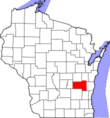 | |
| Villages | ||
| Towns | ||
| CDPs | ||
| Unincorporated communities |
| |
| Ghost towns | ||
| Footnotes | ‡This populated place also has portions in an adjacent county or counties | |